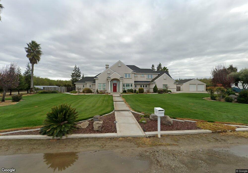
2148 N Hart Rd Modesto, CA 95358
Estimated Value: $823,000 - $1,361,000
3
Beds
2
Baths
2,877
Sq Ft
$367/Sq Ft
Est. Value
About This Home
This home is located at 2148 N Hart Rd, Modesto, CA 95358 and is currently estimated at $1,056,083, approximately $367 per square foot. 2148 N Hart Rd is a home located in Stanislaus County with nearby schools including Hart-Ransom Elementary School, Modesto High School, and Hart-Ransom Charter School.
Ownership History
Date
Name
Owned For
Owner Type
Purchase Details
Closed on
Feb 10, 2011
Sold by
Citibank Na
Bought by
Riggins Eddie Mark and Riggins Sandra
Current Estimated Value
Home Financials for this Owner
Home Financials are based on the most recent Mortgage that was taken out on this home.
Original Mortgage
$360,000
Outstanding Balance
$245,519
Interest Rate
4.71%
Mortgage Type
New Conventional
Estimated Equity
$810,564
Purchase Details
Closed on
Dec 8, 2010
Sold by
Brown Steven E
Bought by
Citibank Na
Purchase Details
Closed on
Apr 2, 2001
Sold by
Lionudakis Antonio
Bought by
Brown Steven E and Brown Carrie A
Home Financials for this Owner
Home Financials are based on the most recent Mortgage that was taken out on this home.
Original Mortgage
$171,000
Interest Rate
6.98%
Create a Home Valuation Report for This Property
The Home Valuation Report is an in-depth analysis detailing your home's value as well as a comparison with similar homes in the area
Purchase History
| Date | Buyer | Sale Price | Title Company |
|---|---|---|---|
| Riggins Eddie Mark | $480,000 | First American Title Company | |
| Citibank Na | $330,000 | Accommodation | |
| Brown Steven E | $180,000 | First American Title Ins Co |
Source: Public Records
Mortgage History
| Date | Status | Borrower | Loan Amount |
|---|---|---|---|
| Open | Riggins Eddie Mark | $360,000 | |
| Previous Owner | Brown Steven E | $171,000 |
Source: Public Records
Tax History
| Year | Tax Paid | Tax Assessment Tax Assessment Total Assessment is a certain percentage of the fair market value that is determined by local assessors to be the total taxable value of land and additions on the property. | Land | Improvement |
|---|---|---|---|---|
| 2025 | $6,844 | $614,948 | $147,967 | $466,981 |
| 2024 | $6,722 | $602,891 | $145,066 | $457,825 |
| 2023 | $6,575 | $591,071 | $142,222 | $448,849 |
| 2022 | $6,308 | $579,483 | $139,434 | $440,049 |
| 2021 | $6,190 | $568,121 | $136,700 | $431,421 |
| 2020 | $6,094 | $562,297 | $135,299 | $426,998 |
| 2019 | $5,984 | $551,273 | $132,647 | $418,626 |
| 2018 | $5,887 | $540,465 | $130,047 | $410,418 |
| 2017 | $5,697 | $529,869 | $127,498 | $402,371 |
| 2016 | $5,647 | $519,481 | $124,999 | $394,482 |
| 2015 | $5,412 | $511,679 | $123,122 | $388,557 |
| 2014 | $5,309 | $501,657 | $120,711 | $380,946 |
Source: Public Records
Map
Nearby Homes
- 6613 Woodland Ave
- 0 Blue Gum Ave Unit 226013904
- 5509 Pountsmonth Dr
- 4220 Plemini Ct
- 0 Finney Rd
- 5412 Port Alice Way
- 5409 Covert Rd
- 4221 Legacy Ct
- 4609 Sweet William Ct
- 4736 Carlson Way
- 4731 Rollingwood Dr
- 5304 Countrybrook Ln
- 5100 Kiernan Ave
- 5000 Kiernan Ave
- 3424 Vintage Dr Unit 244
- 3424 Vintage Dr Unit 152
- 3400 Sullivan Ct Unit 105
- 3400 Sullivan Ct Unit 106
- 4524 Wessex Ln
- 5121 Durley Dr
- 2266 N Hart Rd
- 6936 Shoemake Ave
- 7037 Shoemake Ave
- 7037 Shoemake Ave
- 0 Shoemake Ave Unit 18057548
- 0 Shoemake Ave Unit 90071993
- 0 Shoemake Ave Unit 13038049
- 0 Shoemake Ave Unit 14019420
- 0 Shoemake Ave Unit 18022461
- 0 Shoemake Ave Unit MC14068684
- 0 Shoemake Ave Unit 222143917
- 0 Shoemake Ave Unit 423988
- 0 Shoemake Ave Unit 70076538
- 0 Shoemake Ave Unit 70052769
- 0 Shoemake Ave Unit 13001382
- 0 Shoemake Ave Unit 19002493
- 2319 N Hart Rd
- 2324 N Hart Rd
- 6754 Shoemake Ave
- 2343 N Hart Rd
Your Personal Tour Guide
Ask me questions while you tour the home.