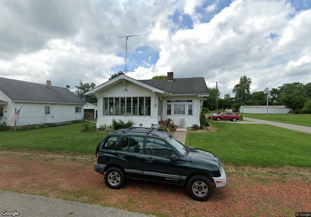
215 N Oxford St Milroy, IN 46156
Estimated Value: $166,446 - $198,000
3
Beds
2
Baths
2,588
Sq Ft
$69/Sq Ft
Est. Value
About This Home
This home is located at 215 N Oxford St, Milroy, IN 46156 and is currently estimated at $179,612, approximately $69 per square foot. 215 N Oxford St is a home located in Rush County with nearby schools including Rushville Consolidated High School, Flat Rock Amish School, and Center Square Amish.
Ownership History
Date
Name
Owned For
Owner Type
Purchase Details
Closed on
Nov 26, 2012
Sold by
Nat'L Mtg Assoc Federal
Bought by
Schwering Nancy L
Current Estimated Value
Purchase Details
Closed on
Mar 27, 2012
Sold by
Hodson Shelly P
Bought by
Federal National Mortgage Association
Purchase Details
Closed on
Mar 9, 2007
Sold by
Gerrian Phillip R and Gerrian Kimberly S
Bought by
Hodson Stanley O and Hodson Shelly P
Home Financials for this Owner
Home Financials are based on the most recent Mortgage that was taken out on this home.
Original Mortgage
$28,400
Interest Rate
6.27%
Mortgage Type
Stand Alone Second
Create a Home Valuation Report for This Property
The Home Valuation Report is an in-depth analysis detailing your home's value as well as a comparison with similar homes in the area
Home Values in the Area
Average Home Value in this Area
Purchase History
| Date | Buyer | Sale Price | Title Company |
|---|---|---|---|
| Schwering Nancy L | $67,000 | -- | |
| Federal National Mortgage Association | $97,266 | None Available | |
| Hodson Stanley O | -- | None Available |
Source: Public Records
Mortgage History
| Date | Status | Borrower | Loan Amount |
|---|---|---|---|
| Previous Owner | Hodson Stanley O | $28,400 | |
| Previous Owner | Hodson Stanley O | $85,100 |
Source: Public Records
Tax History Compared to Growth
Tax History
| Year | Tax Paid | Tax Assessment Tax Assessment Total Assessment is a certain percentage of the fair market value that is determined by local assessors to be the total taxable value of land and additions on the property. | Land | Improvement |
|---|---|---|---|---|
| 2024 | $468 | $141,000 | $6,500 | $134,500 |
| 2023 | $459 | $130,400 | $6,100 | $124,300 |
| 2022 | $450 | $120,300 | $6,100 | $114,200 |
| 2021 | $575 | $107,200 | $6,100 | $101,100 |
| 2020 | $644 | $115,000 | $6,100 | $108,900 |
| 2019 | $543 | $108,300 | $6,100 | $102,200 |
| 2018 | $491 | $105,000 | $6,100 | $98,900 |
| 2017 | $414 | $101,300 | $6,100 | $95,200 |
| 2016 | $360 | $96,600 | $5,800 | $90,800 |
| 2014 | $244 | $95,800 | $5,700 | $90,100 |
| 2013 | $244 | $95,800 | $5,700 | $90,100 |
Source: Public Records
Map
Nearby Homes
- 311 S Pleasant St
- 7371 S 200 W
- 9251 S State Road 3
- 651 E County Road 800 N
- 3931 S Flatrock River Rd
- Tract 2: 8342 S 650 W
- Tract 1: 8342 S 650 W
- 7288 Broadview Ln
- 5279 E County Road 800 N
- 5553 N County Road 10 E
- 5752 N Co Road 400 E
- 4343 N Co Road 200 E
- 1454 S Dover Dr
- 428 W Lawton Cir
- 575 E Cameron Dr
- 1364 S Ruth St
- 1157 S State Road 3
- 5455 E Us Highway 52
- 3990 W State Road 44
- 190 E Willard Ave
- 211 N Oxford St
- 214 N Oxford St
- 220 N Oxford St
- 203 N Oxford St
- 201 E Moose St
- 221 N Oxford St
- 220 N Gano St
- 210 E Church St
- 304 E Church St
- 304 E Church St
- 226 N Gano St
- 227 N Oxford St
- 307 N Walnut St
- 215 N Walnut St
- 211 N Walnut St
- 204 E Church St
- 310 E Moose St
- 205 E Root St
- 211 N Gano St
- 310 E Church St