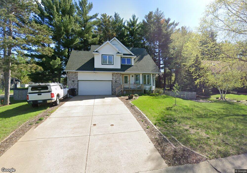
2151 142nd Ave NW Andover, MN 55304
Estimated Value: $383,000 - $402,000
3
Beds
3
Baths
1,830
Sq Ft
$214/Sq Ft
Est. Value
About This Home
This home is located at 2151 142nd Ave NW, Andover, MN 55304 and is currently estimated at $390,850, approximately $213 per square foot. 2151 142nd Ave NW is a home located in Anoka County with nearby schools including Crooked Lake Elementary School, Oak View Middle School, and Andover Senior High School.
Ownership History
Date
Name
Owned For
Owner Type
Purchase Details
Closed on
Oct 20, 2017
Sold by
Burns Lynn H and Burns Donald C
Bought by
Flanagan Andrea
Current Estimated Value
Home Financials for this Owner
Home Financials are based on the most recent Mortgage that was taken out on this home.
Original Mortgage
$229,900
Outstanding Balance
$192,083
Interest Rate
3.83%
Mortgage Type
New Conventional
Estimated Equity
$198,767
Purchase Details
Closed on
Oct 23, 2000
Sold by
Nast Donald W and Nast Jennifer L
Bought by
Burns Donald C and Leary Lynn H
Create a Home Valuation Report for This Property
The Home Valuation Report is an in-depth analysis detailing your home's value as well as a comparison with similar homes in the area
Home Values in the Area
Average Home Value in this Area
Purchase History
| Date | Buyer | Sale Price | Title Company |
|---|---|---|---|
| Flanagan Andrea | $242,000 | Burnet Title | |
| Burns Donald C | $185,900 | -- |
Source: Public Records
Mortgage History
| Date | Status | Borrower | Loan Amount |
|---|---|---|---|
| Open | Flanagan Andrea | $229,900 |
Source: Public Records
Tax History Compared to Growth
Tax History
| Year | Tax Paid | Tax Assessment Tax Assessment Total Assessment is a certain percentage of the fair market value that is determined by local assessors to be the total taxable value of land and additions on the property. | Land | Improvement |
|---|---|---|---|---|
| 2025 | $3,377 | $361,400 | $109,800 | $251,600 |
| 2024 | $3,377 | $338,600 | $92,600 | $246,000 |
| 2023 | $3,223 | $354,300 | $92,600 | $261,700 |
| 2022 | $3,057 | $349,900 | $84,200 | $265,700 |
| 2021 | $2,952 | $291,000 | $70,700 | $220,300 |
| 2020 | $2,847 | $275,700 | $67,400 | $208,300 |
| 2019 | $2,646 | $259,100 | $64,300 | $194,800 |
| 2018 | $2,789 | $237,800 | $0 | $0 |
| 2017 | $2,468 | $244,700 | $0 | $0 |
| 2016 | $2,554 | $215,700 | $0 | $0 |
| 2015 | $2,351 | $215,700 | $53,900 | $161,800 |
| 2014 | -- | $175,800 | $35,100 | $140,700 |
Source: Public Records
Map
Nearby Homes
- 14395 Partridge St NW
- 14404 Osage St NW
- 13919 Nightingale St NW
- 13993 Crosstown Blvd NW
- 14553 Ibis St NW
- 14780 Jay St NW
- 2080 151st Ave NW
- 13871 Eidelweiss St NW
- 2066 151st Ave NW
- 2115 134th Ave NW
- 917 174th Ave NE
- 14994 Crane St NW
- 1184 143rd Ave NW
- 14023 Yellow Pine St NW
- 2334 Veterans Memorial Blvd NW
- 15285 Quinn St NW
- TBD Gladiola St NW
- Lot 5 Gladiola St NW
- 2481 132nd Ln NW
- 2743 134th Ln NW
- 2139 142nd Ave NW
- 26XX S Coon Creek Dr
- 27XX S Coon Creek Drive-Drive-nw
- 27XX S Coon Creek Dr
- 2126 142nd Ln NW
- 2176 142nd Ln NW
- 2127 142nd Ave NW
- 14194 Quinn St NW
- 2141 142nd Ln NW
- 2153 142nd Ln NW
- 2186 142nd Ln NW
- 2129 142nd Ln NW
- 2187 142nd Ln NW
- 2115 142nd Ave NW
- 14184 Quinn St NW
- 2196 142nd Ln NW
- 2117 142nd Ln NW
- 2197 142nd Ln NW
- 14317 Crosstown Blvd NW
- 2102 142nd Ln NW