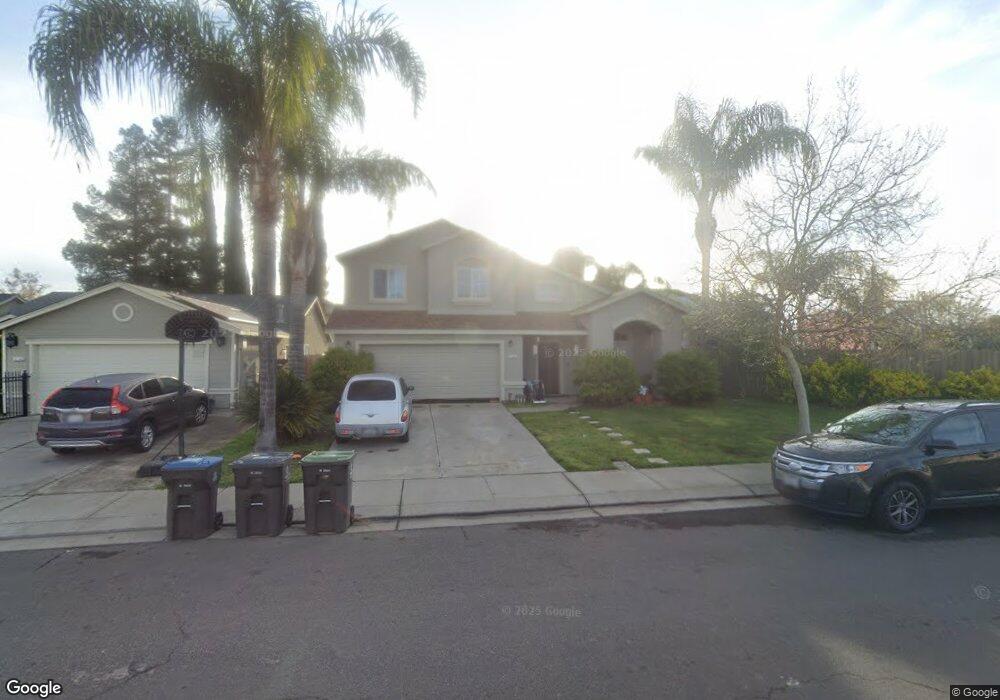
2164 Tillie Lewis Dr Stockton, CA 95206
Seaport NeighborhoodEstimated Value: $370,000 - $474,000
3
Beds
3
Baths
1,781
Sq Ft
$241/Sq Ft
Est. Value
About This Home
This home is located at 2164 Tillie Lewis Dr, Stockton, CA 95206 and is currently estimated at $428,556, approximately $240 per square foot. 2164 Tillie Lewis Dr is a home located in San Joaquin County with nearby schools including San Joaquin Elementary School, John Marshall Elementary School, and Taylor Leadership Academy.
Ownership History
Date
Name
Owned For
Owner Type
Purchase Details
Closed on
Oct 9, 1996
Sold by
R E Development Corporation
Bought by
Pitre Patrick and Pitre Julienne
Current Estimated Value
Home Financials for this Owner
Home Financials are based on the most recent Mortgage that was taken out on this home.
Original Mortgage
$114,111
Outstanding Balance
$10,496
Interest Rate
8.11%
Mortgage Type
FHA
Estimated Equity
$418,060
Create a Home Valuation Report for This Property
The Home Valuation Report is an in-depth analysis detailing your home's value as well as a comparison with similar homes in the area
Home Values in the Area
Average Home Value in this Area
Purchase History
| Date | Buyer | Sale Price | Title Company |
|---|---|---|---|
| Pitre Patrick | $115,000 | Old Republic Title Company |
Source: Public Records
Mortgage History
| Date | Status | Borrower | Loan Amount |
|---|---|---|---|
| Open | Pitre Patrick | $114,111 |
Source: Public Records
Tax History Compared to Growth
Tax History
| Year | Tax Paid | Tax Assessment Tax Assessment Total Assessment is a certain percentage of the fair market value that is determined by local assessors to be the total taxable value of land and additions on the property. | Land | Improvement |
|---|---|---|---|---|
| 2025 | $2,482 | $194,610 | $40,711 | $153,899 |
| 2024 | $2,440 | $190,795 | $39,913 | $150,882 |
| 2023 | $2,384 | $187,055 | $39,131 | $147,924 |
| 2022 | $2,246 | $183,388 | $38,364 | $145,024 |
| 2021 | $2,162 | $179,793 | $37,612 | $142,181 |
| 2020 | $2,203 | $177,951 | $37,227 | $140,724 |
| 2019 | $2,192 | $174,463 | $36,498 | $137,965 |
| 2018 | $2,583 | $171,043 | $35,783 | $135,260 |
| 2017 | $2,377 | $167,690 | $35,082 | $132,608 |
| 2016 | $2,393 | $164,402 | $34,394 | $130,008 |
| 2014 | $2,276 | $158,762 | $33,214 | $125,548 |
Source: Public Records
Map
Nearby Homes
- 2050 Grey Stone Dr
- 1823 Fort Hall Place
- 2128 Green River Ln
- 2650 S Fresno Ave
- 1409 Laguna Cir
- 1413 Laguna Cir
- 1156 Derrick Dr
- 1232 Denver Ave
- 2215 Dune Place
- 2242 Port Trinity Cir
- 864 W 5th St
- 2402 Sailboat Ct
- 2428 Shell Ct
- 2079 Gordon Verner Cir
- 3745 Wild Rose Ln
- 2625 Crestmore Cir
- 1661 W Hazelton Ave
- 309 S Los Angeles Ave
- 348 S Los Angeles Ave
- 1765 W Sonora St
- 2150 Tillie Lewis Dr
- 2219 Saint Lakes Way
- 2125 Middle River Dr
- 2136 Tillie Lewis Dr
- 2117 Middle River Dr
- 2237 Saint Lakes Way
- 2211 Saint Lakes Way
- 2109 Middle River Dr
- 2120 Tillie Lewis Dr
- 2157 Tillie Lewis Dr
- 2139 Tillie Lewis Dr
- 2073 Middle River Dr
- 2307 Blue Tees Dr
- 2319 Blue Tees Dr
- 2106 Tillie Lewis Dr
- 2224 Saint Lakes Way
- 2061 Middle River Dr
- 2168 Red River Ct
- 2053 Tillie Lewis Dr
- 2157 Saint Lakes Way