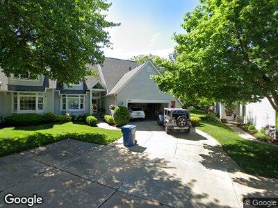
217 Delaware Trail Unit G16F/1 Copley, OH 44321
Estimated Value: $305,859 - $324,000
3
Beds
3
Baths
2,460
Sq Ft
$130/Sq Ft
Est. Value
About This Home
This home is located at 217 Delaware Trail Unit G16F/1, Copley, OH 44321 and is currently estimated at $318,715, approximately $129 per square foot. 217 Delaware Trail Unit G16F/1 is a home located in Summit County with nearby schools including Richfield Elementary School, Bath Elementary School, and Revere Middle School.
Ownership History
Date
Name
Owned For
Owner Type
Purchase Details
Closed on
May 23, 2007
Sold by
Fredrick Ruth A
Bought by
Reuscher William and Reuscher Mona
Current Estimated Value
Home Financials for this Owner
Home Financials are based on the most recent Mortgage that was taken out on this home.
Original Mortgage
$110,000
Interest Rate
6.27%
Mortgage Type
Purchase Money Mortgage
Purchase Details
Closed on
Dec 19, 2006
Sold by
Fredrick Ruth A and Fredrick Wayne D
Bought by
Fredrick Ruth A and The Ruth A Fredrick Family Trust
Purchase Details
Closed on
Mar 3, 1999
Sold by
Fredrick Wayne D and Fredrick Ruth A
Bought by
Fredrick Wayne D and Fredrick Family Trust
Create a Home Valuation Report for This Property
The Home Valuation Report is an in-depth analysis detailing your home's value as well as a comparison with similar homes in the area
Home Values in the Area
Average Home Value in this Area
Purchase History
| Date | Buyer | Sale Price | Title Company |
|---|---|---|---|
| Reuscher William | $265,000 | Lawyers Title Ins | |
| Fredrick Ruth A | -- | First American Title Akron | |
| Fredrick Ruth A | -- | First American Title Akron | |
| Fredrick Wayne D | -- | First American Title Ins Co | |
| Fredrick Wayne D | -- | -- |
Source: Public Records
Mortgage History
| Date | Status | Borrower | Loan Amount |
|---|---|---|---|
| Closed | Reuscher William | $110,000 | |
| Previous Owner | Fredrick Wayne D | $175,000 | |
| Previous Owner | Fredrick Wayne D | $182,750 |
Source: Public Records
Tax History Compared to Growth
Tax History
| Year | Tax Paid | Tax Assessment Tax Assessment Total Assessment is a certain percentage of the fair market value that is determined by local assessors to be the total taxable value of land and additions on the property. | Land | Improvement |
|---|---|---|---|---|
| 2025 | $4,041 | $89,352 | $10,745 | $78,607 |
| 2024 | $4,041 | $89,352 | $10,745 | $78,607 |
| 2023 | $4,041 | $89,352 | $10,745 | $78,607 |
| 2022 | $3,479 | $69,899 | $8,397 | $61,502 |
| 2021 | $3,368 | $69,899 | $8,397 | $61,502 |
| 2020 | $3,286 | $69,900 | $8,400 | $61,500 |
| 2019 | $3,256 | $66,000 | $8,310 | $57,690 |
| 2018 | $3,116 | $66,000 | $8,310 | $57,690 |
| 2017 | $2,798 | $66,000 | $8,310 | $57,690 |
| 2016 | $2,899 | $60,910 | $8,310 | $52,600 |
| 2015 | $2,798 | $60,910 | $8,310 | $52,600 |
| 2014 | $3,318 | $60,910 | $8,310 | $52,600 |
| 2013 | $4,194 | $76,470 | $8,310 | $68,160 |
Source: Public Records
Map
Nearby Homes
- 522 Robinwood Ln Unit H
- 282 Hollythorn Dr
- 118 Lethbridge Cir
- 494 Arbor Ln
- 81 Rotili Ln
- 4339 Sierra Dr
- 523 Arbor Ln
- V/L 4655 Medina Rd
- 443 S Hametown Rd
- 414 Kings Ct
- 4212 Castle Ridge
- 3719 Overlook Ct
- 304 Arboretum Ct
- 93 N Hametown Rd
- 4590 Rockridge Way
- 4474 Litchfield Dr
- 218 Treetop Spur
- 4012 Stonebridge Blvd
- 274 Elm Ln
- 4572 Litchfield Dr
- 4128 Shawnee Trail Unit 42H/1
- 4132 Shawnee Trail
- 4136 Shawnee Trail Unit 40G
- 217 Delaware Trail Unit G16F/1
- 213 Delaware Trail
- 209 Delaware Trail Unit G14H/1
- 213 Delaware Trail Unit 15
- 4131 Mohawk Dr
- 4135 Mohawk Dr
- 277 Adena Trace Unit 60F
- 154 Tecumseh Ln
- 158 Tecumseh Ln
- 279 Adena Trace
- 4163 Tomahawk Trace Unit E39F
- 155 Tecumseh Ln
- 153 Tecumseh Ln Unit 28D
- 4169 Tomahawk Trace Unit 36G/3
- 273 Adena Trace Unit 58G
- 270 Adena Trace
- 197 Delaware Trail