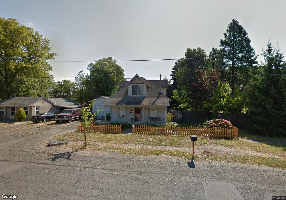
217 N 12th St Philomath, OR 97370
Estimated Value: $471,000 - $514,000
2
Beds
2
Baths
1,930
Sq Ft
$251/Sq Ft
Est. Value
About This Home
This home is located at 217 N 12th St, Philomath, OR 97370 and is currently estimated at $484,092, approximately $250 per square foot. 217 N 12th St is a home located in Benton County with nearby schools including Philomath Elementary School, Clemens Primary School, and Philomath Middle School.
Ownership History
Date
Name
Owned For
Owner Type
Purchase Details
Closed on
Apr 23, 2009
Sold by
Hall James R and Hall Elaine O
Bought by
Ainsworth Justin Campbell and Ainsworth Dana Marye
Current Estimated Value
Home Financials for this Owner
Home Financials are based on the most recent Mortgage that was taken out on this home.
Original Mortgage
$217,490
Outstanding Balance
$137,486
Interest Rate
5.02%
Mortgage Type
FHA
Estimated Equity
$346,606
Create a Home Valuation Report for This Property
The Home Valuation Report is an in-depth analysis detailing your home's value as well as a comparison with similar homes in the area
Home Values in the Area
Average Home Value in this Area
Purchase History
| Date | Buyer | Sale Price | Title Company |
|---|---|---|---|
| Ainsworth Justin Campbell | $237,500 | Amerititle |
Source: Public Records
Mortgage History
| Date | Status | Borrower | Loan Amount |
|---|---|---|---|
| Open | Ainsworth Justin Campbell | $217,490 |
Source: Public Records
Tax History Compared to Growth
Tax History
| Year | Tax Paid | Tax Assessment Tax Assessment Total Assessment is a certain percentage of the fair market value that is determined by local assessors to be the total taxable value of land and additions on the property. | Land | Improvement |
|---|---|---|---|---|
| 2025 | $3,018 | $149,290 | -- | -- |
| 2024 | $3,018 | $144,942 | -- | -- |
| 2023 | $2,861 | $140,720 | $0 | $0 |
| 2022 | $2,778 | $136,621 | $0 | $0 |
| 2021 | $2,699 | $132,642 | $0 | $0 |
| 2020 | $2,715 | $128,779 | $0 | $0 |
| 2019 | $2,520 | $125,028 | $0 | $0 |
| 2018 | $2,537 | $121,386 | $0 | $0 |
| 2017 | $2,478 | $117,850 | $0 | $0 |
| 2016 | $2,376 | $114,417 | $0 | $0 |
| 2015 | $2,249 | $111,084 | $0 | $0 |
| 2014 | $2,216 | $107,849 | $0 | $0 |
| 2012 | -- | $101,658 | $0 | $0 |
Source: Public Records
Map
Nearby Homes
- 345 N 11th (351) St
- 223 N 14th St
- 990 Pippa Ln
- 803 Main St
- 1717 Main St
- 807 N 12th St
- 881 Quail Glenn Dr
- 807 Quail Glenn Dr
- 769 N 9th St
- 791 Quail Glenn Dr
- 852 Marilyn Dr
- 801 Quail Glenn Dr
- 240 N 19th St
- 1502 Timothy St
- 235 S 18th St
- 609 Coastal View (Land Next To) Dr
- 538 Starlight Way
- 760 S 16th St
- 135 S 21st St
- 609 Coastal View Dr (Lan
- 203 N 12th St
- 229 N 12th St
- 212 N 13th St
- 228 N 13th St
- 240 N 13th St
- 1234 College St
- 1140 Pioneer St
- 280 N 13th St
- 139 N 12th St
- 35577 Swordfern Ridge Rd
- 0 Porter Rd Unit 719256
- 0 Porter Rd Unit 709382
- 0 Porter Rd Unit 9041754
- 0 Porter Rd Unit 741308
- 121 N 12th St
- 121 N 12th (-123) St
- 1215 Pioneer St
- 1215 Pioneer St
- lot 46 College St
- 1130 Pioneer St