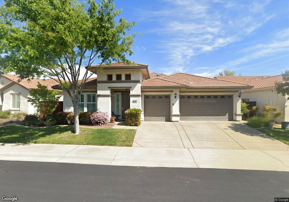
2176 Devonport Loop Roseville, CA 95747
Estimated Value: $765,000 - $892,000
3
Beds
3
Baths
2,732
Sq Ft
$292/Sq Ft
Est. Value
About This Home
This home is located at 2176 Devonport Loop, Roseville, CA 95747 and is currently estimated at $797,222, approximately $291 per square foot. 2176 Devonport Loop is a home located in Placer County with nearby schools including Junction Elementary, Barbara Chilton Middle School, and West Park High School.
Ownership History
Date
Name
Owned For
Owner Type
Purchase Details
Closed on
Feb 22, 2023
Sold by
Oberdank Family Trust
Bought by
Oberdank Jody F
Current Estimated Value
Purchase Details
Closed on
Oct 31, 2013
Sold by
Oberdank Terry and Oberdank Jody Francine
Bought by
Oberdank Terry and Oberdank Jody F
Purchase Details
Closed on
Sep 3, 2008
Sold by
Pulte Home Corp
Bought by
Oberdank Terry and Oberdank Jody Francine
Create a Home Valuation Report for This Property
The Home Valuation Report is an in-depth analysis detailing your home's value as well as a comparison with similar homes in the area
Home Values in the Area
Average Home Value in this Area
Purchase History
| Date | Buyer | Sale Price | Title Company |
|---|---|---|---|
| Oberdank Jody F | -- | -- | |
| Oberdank Terry | -- | None Available | |
| Oberdank Terry | $450,000 | First American Title Company |
Source: Public Records
Tax History
| Year | Tax Paid | Tax Assessment Tax Assessment Total Assessment is a certain percentage of the fair market value that is determined by local assessors to be the total taxable value of land and additions on the property. | Land | Improvement |
|---|---|---|---|---|
| 2025 | $8,673 | $593,258 | $115,891 | $477,367 |
| 2023 | $8,673 | $570,223 | $111,392 | $458,831 |
| 2022 | $8,445 | $559,043 | $109,208 | $449,835 |
| 2021 | $8,238 | $548,082 | $107,067 | $441,015 |
| 2020 | $8,081 | $542,463 | $105,970 | $436,493 |
| 2019 | $7,887 | $531,828 | $103,893 | $427,935 |
| 2018 | $7,681 | $521,401 | $101,856 | $419,545 |
| 2017 | $7,552 | $511,178 | $99,859 | $411,319 |
| 2016 | $7,565 | $501,155 | $97,901 | $403,254 |
| 2015 | $7,439 | $493,628 | $96,431 | $397,197 |
| 2014 | $7,361 | $483,960 | $94,543 | $389,417 |
Source: Public Records
Map
Nearby Homes
- 3201 Monument Dr
- 2446 Langtree Dr
- 2096 Land End Loop
- 2128 Land End Loop
- 3040 Village Plaza Dr
- 2112 Leighham Dr
- 5297 Angelrock Loop
- 5224 Dreamgarden Loop
- 2032 Brixham Dr
- 2160 Arlington Dr
- 1037 Billington Ln
- 2209 Coryton Ln
- 2120 Arlington Dr
- 1041 Essington Ln
- 1960 Culverhill Way
- 5072 Dreamgarden Loop
- 3241 Village Center Dr
- 2401 Pleasant Grove Blvd
- 6108 Granite Flat Ln
- 4796 Mount Rose Way
- 2184 Devonport Loop
- 2168 Devonport Loop
- 2169 Devonport Loop
- 2185 Devonport Loop
- 2177 Devonport Loop
- 2192 Devonport Loop
- 2160 Devonport Loop
- 2217 Devonport Loop
- 2161 Devonport Loop
- 2200 Devonport Loop
- 2225 Devonport Loop
- 125 Cove Ct
- 2208 Devonport Loop
- 2051 Enzie Ln
- 2152 Devonport Loop
- 2059 Enzie Ln
- 2216 Devonport Loop
- 100 Enzie Ct
- 108 Cove Ct
- 2113 Devonport Loop
Your Personal Tour Guide
Ask me questions while you tour the home.