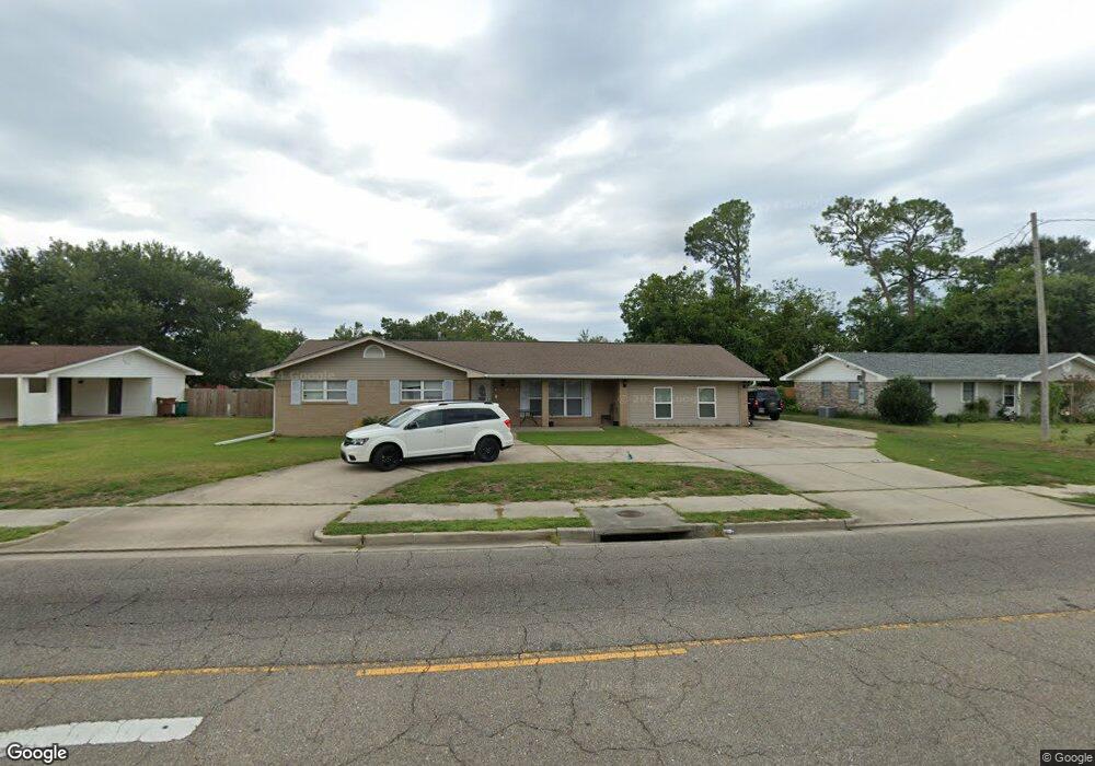
2182 Popps Ferry Rd Biloxi, MS 39532
Estimated Value: $188,452 - $240,000
4
Beds
1
Bath
2,270
Sq Ft
$94/Sq Ft
Est. Value
About This Home
This home is located at 2182 Popps Ferry Rd, Biloxi, MS 39532 and is currently estimated at $212,863, approximately $93 per square foot. 2182 Popps Ferry Rd is a home located in Harrison County with nearby schools including North Bay Elementary School, Biloxi Junior High School, and Biloxi High School.
Ownership History
Date
Name
Owned For
Owner Type
Purchase Details
Closed on
Jun 9, 2017
Sold by
Daley David and Daley Paula
Bought by
Smith Megan Sedion Davy
Current Estimated Value
Home Financials for this Owner
Home Financials are based on the most recent Mortgage that was taken out on this home.
Original Mortgage
$137,645
Outstanding Balance
$114,311
Interest Rate
4.05%
Mortgage Type
FHA
Estimated Equity
$98,552
Purchase Details
Closed on
May 21, 2015
Bought by
David and David Paula
Create a Home Valuation Report for This Property
The Home Valuation Report is an in-depth analysis detailing your home's value as well as a comparison with similar homes in the area
Home Values in the Area
Average Home Value in this Area
Purchase History
| Date | Buyer | Sale Price | Title Company |
|---|---|---|---|
| Smith Megan Sedion Davy | -- | -- | |
| David | -- | -- |
Source: Public Records
Mortgage History
| Date | Status | Borrower | Loan Amount |
|---|---|---|---|
| Open | Smith Megan Sedion Davy | $137,645 |
Source: Public Records
Tax History Compared to Growth
Tax History
| Year | Tax Paid | Tax Assessment Tax Assessment Total Assessment is a certain percentage of the fair market value that is determined by local assessors to be the total taxable value of land and additions on the property. | Land | Improvement |
|---|---|---|---|---|
| 2025 | $892 | $10,667 | $0 | $0 |
| 2024 | $819 | $10,103 | $0 | $0 |
| 2023 | $821 | $10,216 | $0 | $0 |
| 2022 | $1,121 | $10,216 | $0 | $0 |
| 2021 | $821 | $10,216 | $0 | $0 |
| 2020 | $697 | $9,071 | $0 | $0 |
| 2019 | $672 | $9,071 | $0 | $0 |
| 2018 | $1,458 | $8,843 | $0 | $0 |
| 2017 | $1,458 | $13,265 | $0 | $0 |
| 2015 | $729 | $9,365 | $0 | $0 |
| 2014 | -- | $6,865 | $0 | $0 |
| 2013 | -- | $9,365 | $2,500 | $6,865 |
Source: Public Records
Map
Nearby Homes
- 844 Carolee Cir
- 2158 Baywood Dr
- 2011 Ivy Ct
- 930 Wildwood Ln
- 2022 Lantana Cove
- 856 Rustwood Dr
- 2230 Baywood Dr
- 816 Lackland Dr
- 2032 Englewood Dr
- 0 Oleander Ln
- 2082 Juniper Dr
- 2285 Harkness Ct
- 2115 Lauren Dr
- 2090 Woodfield Ln
- 2265 Popp's Ferry Rd
- 2106 Lauren Dr
- 796 Sharon Hills Dr
- 2325 N Country Club Ln
- 2331 Rue Maison
- 774 Sharon Hills Dr
- 2180 Popps Ferry Rd
- 2190 Popps Ferry Rd
- 882 Lackland Dr
- 880 Lackland Dr
- 2185 Popps Ferry Rd
- 886 Lackland Dr
- 2178 Popps Ferry Rd
- 2191 Popps Ferry Rd
- 2196 Popps Ferry Rd
- 2181 Popps Ferry Rd
- 2193 Popps Ferry Rd
- 890 Lackland Dr
- 876 Lackland Dr
- 2174 Popps Ferry Rd
- 2188 Baywood Dr
- 2190 Baywood Dr
- 2177 Popps Ferry Rd
- 898 Auburn Dr
- 2194 Baywood Dr
- 2186 Baywood Dr