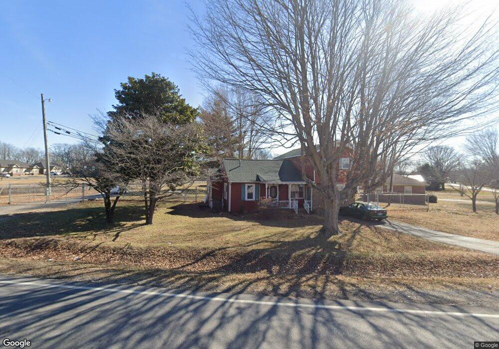
219 Freedom Dr Portland, TN 37148
Estimated Value: $274,000 - $287,859
4
Beds
2
Baths
1,744
Sq Ft
$160/Sq Ft
Est. Value
About This Home
This home is located at 219 Freedom Dr, Portland, TN 37148 and is currently estimated at $278,715, approximately $159 per square foot. 219 Freedom Dr is a home located in Sumner County with nearby schools including Portland Gateview Elementary School, Portland West Middle School, and Portland High School.
Ownership History
Date
Name
Owned For
Owner Type
Purchase Details
Closed on
Jul 29, 2025
Sold by
Carter James A and Carter Lori A
Bought by
James And Lori Carter /2025 Revocable Lying T and Carter
Current Estimated Value
Purchase Details
Closed on
Aug 18, 2017
Sold by
White White H and White Catherine
Bought by
Carter James A and Carter Lori A
Purchase Details
Closed on
May 11, 1995
Sold by
White H V
Bought by
City Of Portland
Create a Home Valuation Report for This Property
The Home Valuation Report is an in-depth analysis detailing your home's value as well as a comparison with similar homes in the area
Home Values in the Area
Average Home Value in this Area
Purchase History
| Date | Buyer | Sale Price | Title Company |
|---|---|---|---|
| James And Lori Carter /2025 Revocable Lying T | -- | None Listed On Document | |
| James And Lori Carter /2025 Revocable Lying T | -- | None Listed On Document | |
| Carter James A | $143,000 | None Available | |
| City Of Portland | $400 | -- |
Source: Public Records
Tax History Compared to Growth
Tax History
| Year | Tax Paid | Tax Assessment Tax Assessment Total Assessment is a certain percentage of the fair market value that is determined by local assessors to be the total taxable value of land and additions on the property. | Land | Improvement |
|---|---|---|---|---|
| 2024 | $772 | $54,350 | $16,250 | $38,100 |
| 2023 | $1,135 | $33,275 | $11,925 | $21,350 |
| 2022 | $1,106 | $33,275 | $11,925 | $21,350 |
| 2021 | $1,106 | $33,275 | $11,925 | $21,350 |
| 2020 | $1,106 | $33,275 | $11,925 | $21,350 |
| 2019 | $1,506 | $0 | $0 | $0 |
| 2018 | $738 | $0 | $0 | $0 |
| 2017 | $700 | $0 | $0 | $0 |
| 2016 | $700 | $0 | $0 | $0 |
| 2015 | -- | $0 | $0 | $0 |
| 2014 | -- | $0 | $0 | $0 |
Source: Public Records
Map
Nearby Homes
- 134 N Russell St
- 113 Morningside Dr
- 205 College St
- 104 Morningside Dr
- 202 College St
- 419 N Russell St
- 410 College St
- 408 W Mcglothlin St
- 504 N Russell St
- 207 Center St
- 117 Church St
- 305 Church St
- 301 Church St
- 302 Church St
- 110 Gayla Ct
- 102 Gayla Ct
- 408 Church St
- 406 Church St
- 410 Church St
- 116 North St
- 331 Reed St
- 329 Reed St
- 327 Reed St
- 330 Reed St
- 216 Freedom Dr
- 328 Reed St
- 212 Freedom Dr
- 208 Freedom Dr
- 120 Victor Reiter Pkwy
- 203 Victor Reiter Pkwy
- 204 Freedom Dr
- 324 Reed St
- 118 Victor Reiter Pkwy
- 138 Wind Wood Dr
- 117 Victor Reiter Pkwy
- 321 Reed St Unit 323
- 322 Reed St
- 439 N Broadway
- 202 Victor Reiter Pkwy
- 116 Victor Reiter Pkwy