


2194 Highway 20 E McDonough, GA 30252
Estimated payment $2,250/month
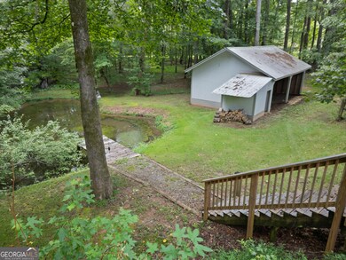
Highlights
- Private Waterfront
- Barn
- Cape Cod Architecture
- Union Grove High School Rated A
- Home fronts a pond
- Stationary Dock
About This Home
NO HOA!!!! This adorable Cape Cod offers the perfect blend of charm, space, and modern updates! Enjoy peaceful living with your own private pond, a barn, and covered parking for up to 5 vehicles-ideal for hobbyists, collectors, or outdoor enthusiasts. Inside, the home has been recently renovated with stylish luxury vinyl plank flooring and quartz countertops in the kitchen, creating a fresh and inviting feel throughout. Step outside to enjoy the screened back porch complete with a relaxing Jacuzzi hot tub-perfect for unwinding after a long day The rural setting provides a sense of privacy and tranquility, yet you're still just minutes from shopping, restaurants, and local conveniences. A rare find that combines country living with everyday comfort! . Whether you're looking for peaceful mornings by the water, room for hobbies, or practical storage, this home delivers it all. Don't miss the opportunity to own a private retreat at an unbeatable price in Henry County! Seller is offering a rate buy down to 4.75% for the buyer who binds a contract before December 31st.
Home Details
Home Type
- Single Family
Est. Annual Taxes
- $4,866
Year Built
- Built in 1987 | Remodeled
Lot Details
- 1.3 Acre Lot
- Home fronts a pond
- Private Waterfront
- Back Yard Fenced
- Private Lot
- Level Lot
- Open Lot
- Partially Wooded Lot
Home Design
- Cape Cod Architecture
- Pillar, Post or Pier Foundation
- Block Foundation
- Composition Roof
- Stone Siding
- Vinyl Siding
- Stone
Interior Spaces
- 1.5-Story Property
- Ceiling Fan
- Fireplace Features Masonry
- Double Pane Windows
- Window Treatments
- Entrance Foyer
- Family Room with Fireplace
- Great Room
- Living Room with Fireplace
- Combination Dining and Living Room
- Screened Porch
- Storm Windows
- Laundry Room
Kitchen
- Breakfast Area or Nook
- Built-In Oven
- Cooktop
- Microwave
- Dishwasher
- Stainless Steel Appliances
- Solid Surface Countertops
Flooring
- Carpet
- Vinyl
Bedrooms and Bathrooms
- 3 Bedrooms | 1 Primary Bedroom on Main
- Walk-In Closet
- Soaking Tub
Basement
- Exterior Basement Entry
- Crawl Space
Parking
- 3 Car Garage
- Carport
- Parking Pad
- Parking Shed
- Side or Rear Entrance to Parking
Eco-Friendly Details
- Energy-Efficient Doors
- Energy-Efficient Thermostat
Outdoor Features
- Stationary Dock
- Patio
- Outdoor Water Feature
- Outbuilding
Schools
- Timber Ridge Elementary School
- Union Grove Middle School
- Union Grove High School
Farming
- Barn
Utilities
- Central Heating and Cooling System
- Heat Pump System
- Heating System Uses Natural Gas
- Heating System Uses Wood
- Underground Utilities
- 220 Volts
- Electric Water Heater
- Septic Tank
- High Speed Internet
- Satellite Dish
- Cable TV Available
Community Details
- No Home Owners Association
Listing and Financial Details
- Tax Lot 54
Map
Home Values in the Area
Average Home Value in this Area
Tax History
| Year | Tax Paid | Tax Assessment Tax Assessment Total Assessment is a certain percentage of the fair market value that is determined by local assessors to be the total taxable value of land and additions on the property. | Land | Improvement |
|---|---|---|---|---|
| 2025 | $5,277 | $132,480 | $18,800 | $113,680 |
| 2024 | $5,277 | $116,600 | $17,280 | $99,320 |
| 2023 | $4,513 | $116,600 | $16,640 | $99,960 |
| 2022 | $3,893 | $100,440 | $15,360 | $85,080 |
| 2021 | $2,974 | $76,480 | $11,000 | $65,480 |
| 2020 | $2,730 | $70,120 | $10,360 | $59,760 |
| 2019 | $2,543 | $65,240 | $9,840 | $55,400 |
| 2018 | $2,306 | $59,080 | $9,080 | $50,000 |
| 2016 | $1,927 | $49,200 | $6,840 | $42,360 |
| 2015 | $1,476 | $36,320 | $6,920 | $29,400 |
| 2014 | $1,316 | $31,880 | $6,920 | $24,960 |
Property History
| Date | Event | Price | List to Sale | Price per Sq Ft |
|---|---|---|---|---|
| 09/23/2025 09/23/25 | Price Changed | $349,900 | -6.7% | -- |
| 08/08/2025 08/08/25 | For Sale | $375,000 | -- | -- |
Purchase History
| Date | Type | Sale Price | Title Company |
|---|---|---|---|
| Deed | $135,000 | -- | |
| Quit Claim Deed | -- | -- | |
| Deed | $123,000 | -- |
Mortgage History
| Date | Status | Loan Amount | Loan Type |
|---|---|---|---|
| Open | $108,000 | New Conventional | |
| Previous Owner | $116,850 | New Conventional |
Source: Georgia MLS
MLS Number: 10580485
APN: 0120-01-006-000
Disclaimer: Certain information contained herein is derived from information provided by parties other than Homes.com. All information provided is deemed reliable, but is not guaranteed to be accurate and should be independently verified.
![]() The data relating to real estate for sale on this web site comes in part from the Broker Reciprocity Program of Georgia MLS. Real estate listings held by brokerage firms other than Redfin are marked with the Broker Reciprocity logo and detailed information about them includes the name of the listing brokers. Information deemed reliable but not guaranteed. Copyright 2025 Georgia MLS. All rights reserved.
The data relating to real estate for sale on this web site comes in part from the Broker Reciprocity Program of Georgia MLS. Real estate listings held by brokerage firms other than Redfin are marked with the Broker Reciprocity logo and detailed information about them includes the name of the listing brokers. Information deemed reliable but not guaranteed. Copyright 2025 Georgia MLS. All rights reserved.
- 2175 Highway 20 E
- 381 Country Lake Dr
- 322 Delta Dr
- 308 Delta Dr
- Meridian II Plan at Trinity Park
- Clarity Plan at Trinity Park
- Rainier Plan at Trinity Park
- Stonefield Plan at Trinity Park
- Isabella II Plan at Trinity Park
- McKinley II Plan at Trinity Park
- Rosemary II Plan at Trinity Park
- 111 Harper Rd
- 121 Harper Rd
- 628 Continental Dr
- 420 Hartsfield Rd
- 504 Dulles Dr
- 515 Dulles Dr
- 45 Gentry Dr
- 100 Ruby Ln
- 100 Ruby Ln
- 47 Lakesprings Dr
- 297 Delta Dr
- 181 Charolais Dr
- 100 Everett Square
- 424 Freeport Way
- 1374 Lake Dow Rd
- 173 Everett Square
- 609 Kristen Ct
- 1390 Ethans Way
- 227 Bella Vista Terrace
- 226 Bella Vista Terrace
- 126 Bellington Dr
- 200 Bella Vista Terrace
- 1205 Polk Crossing
- 104 Bellington Dr
- 35 Little Deer Trail
- 285 Madison Grace Ave
