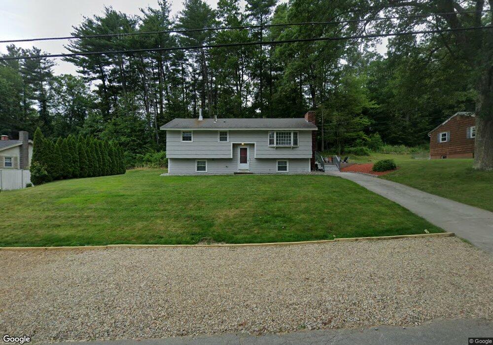
22 Raymond Dr MerriMacK, NH 03054
Estimated Value: $494,000 - $530,000
3
Beds
1
Bath
2,228
Sq Ft
$231/Sq Ft
Est. Value
About This Home
This home is located at 22 Raymond Dr, MerriMacK, NH 03054 and is currently estimated at $515,172, approximately $231 per square foot. 22 Raymond Dr is a home located in Hillsborough County with nearby schools including Reeds Ferry School, James Mastricola Upper Elementary School, and Merrimack Middle School.
Ownership History
Date
Name
Owned For
Owner Type
Purchase Details
Closed on
Aug 19, 2002
Sold by
Kenyon Kathleen M
Bought by
Morrison Brian R and Morrison Shara B
Current Estimated Value
Purchase Details
Closed on
Oct 30, 1996
Sold by
Wyman George M and Wyman Marian D
Bought by
Plummer Dale R and Plummer Jennifer L
Create a Home Valuation Report for This Property
The Home Valuation Report is an in-depth analysis detailing your home's value as well as a comparison with similar homes in the area
Home Values in the Area
Average Home Value in this Area
Purchase History
| Date | Buyer | Sale Price | Title Company |
|---|---|---|---|
| Morrison Brian R | $195,000 | -- | |
| Plummer Dale R | $104,500 | -- |
Source: Public Records
Mortgage History
| Date | Status | Borrower | Loan Amount |
|---|---|---|---|
| Open | Plummer Dale R | $215,084 | |
| Closed | Plummer Dale R | $222,832 | |
| Closed | Plummer Dale R | $46,326 |
Source: Public Records
Tax History Compared to Growth
Tax History
| Year | Tax Paid | Tax Assessment Tax Assessment Total Assessment is a certain percentage of the fair market value that is determined by local assessors to be the total taxable value of land and additions on the property. | Land | Improvement |
|---|---|---|---|---|
| 2024 | $7,055 | $341,000 | $168,300 | $172,700 |
| 2023 | $6,632 | $341,000 | $168,300 | $172,700 |
| 2022 | $5,927 | $341,000 | $168,300 | $172,700 |
| 2021 | $5,855 | $341,000 | $168,300 | $172,700 |
| 2020 | $5,849 | $243,100 | $117,800 | $125,300 |
| 2019 | $5,791 | $240,000 | $117,800 | $122,200 |
| 2018 | $5,681 | $240,000 | $117,800 | $122,200 |
| 2017 | $5,609 | $240,000 | $117,800 | $122,200 |
| 2016 | $5,470 | $240,000 | $117,800 | $122,200 |
| 2015 | $5,050 | $204,300 | $110,900 | $93,400 |
| 2014 | $4,922 | $204,300 | $110,900 | $93,400 |
| 2013 | $4,825 | $201,800 | $110,900 | $90,900 |
Source: Public Records
Map
Nearby Homes
- 33 Belmont Dr
- 29 Bedford Rd
- 12 Davis Rd
- 6 Boulder Way
- 115 Back River Rd
- 490 Charles Bancroft Hwy
- 9 Mustang Dr Unit END UNIT-D
- 9 Mustang Dr Unit C
- 9 Mustang Dr Unit B
- 7 Mustang Dr Unit B
- 7 Mustang Dr Unit END UNIT-A
- 7 Mustang Dr Unit C
- 3 Mustang Dr Unit B
- 6 Stearns Ln Unit 202
- 20 Essex Green Ct
- 12 Clinton Ct
- 14 Bernards Rd
- 12 Bernards Rd
- 3-C Mustang Dr Unit MODEL
- 21 Adams Green