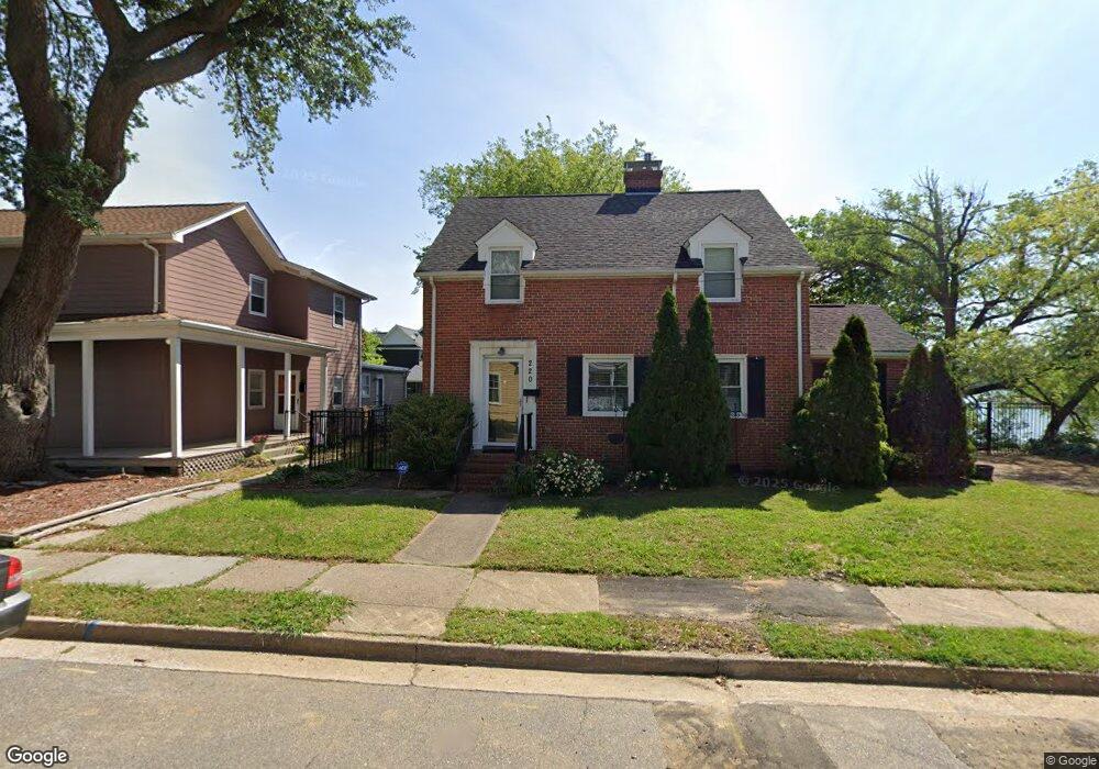
220 Washington St Hampton, VA 23669
Pasture Point NeighborhoodEstimated Value: $311,000 - $335,000
3
Beds
2
Baths
1,932
Sq Ft
$165/Sq Ft
Est. Value
About This Home
This home is located at 220 Washington St, Hampton, VA 23669 and is currently estimated at $318,122, approximately $164 per square foot. 220 Washington St is a home located in Hampton City with nearby schools including Capt. John Smith Elementary School, C. Alton Lindsay Middle School, and Phoebus High School.
Ownership History
Date
Name
Owned For
Owner Type
Purchase Details
Closed on
Jul 25, 2014
Sold by
Mountain Prime Llc
Bought by
Thurrott Sheri D
Current Estimated Value
Purchase Details
Closed on
Apr 11, 2014
Sold by
Federal National Mortgage Association
Bought by
Mountain Prime Llc
Purchase Details
Closed on
May 3, 2013
Sold by
Professional Foreclosure Corp
Bought by
Federal National Mortgage Association
Create a Home Valuation Report for This Property
The Home Valuation Report is an in-depth analysis detailing your home's value as well as a comparison with similar homes in the area
Home Values in the Area
Average Home Value in this Area
Purchase History
| Date | Buyer | Sale Price | Title Company |
|---|---|---|---|
| Thurrott Sheri D | $167,000 | -- | |
| Mountain Prime Llc | $95,000 | -- | |
| Federal National Mortgage Association | $175,613 | -- |
Source: Public Records
Tax History
| Year | Tax Paid | Tax Assessment Tax Assessment Total Assessment is a certain percentage of the fair market value that is determined by local assessors to be the total taxable value of land and additions on the property. | Land | Improvement |
|---|---|---|---|---|
| 2025 | $3,575 | $300,200 | $100,000 | $200,200 |
| 2024 | $3,432 | $298,400 | $100,000 | $198,400 |
| 2023 | $3,355 | $289,200 | $100,000 | $189,200 |
| 2022 | $3,134 | $265,600 | $94,900 | $170,700 |
| 2021 | $2,989 | $230,600 | $94,900 | $135,700 |
| 2020 | $2,846 | $229,500 | $94,500 | $135,000 |
| 2019 | $2,846 | $229,500 | $94,500 | $135,000 |
| 2018 | $3,098 | $229,500 | $94,500 | $135,000 |
| 2017 | $2,940 | $0 | $0 | $0 |
| 2016 | $3,256 | $255,000 | $0 | $0 |
| 2015 | $3,256 | $0 | $0 | $0 |
| 2014 | $3,939 | $310,900 | $127,600 | $183,300 |
Source: Public Records
Map
Nearby Homes
- 301 Washington St
- 233 Mill Point Dr
- 115 E Pembroke Ave
- 421 E Pembroke Ave
- 329 Elm Ave
- 603 Washington St
- 606 Washington St
- 542 River St
- 314 Cooper St
- 311 Cooper St
- 433 Cooper St
- 720 River St
- 439 Cooper St
- 221 Island Cove Ct Unit C
- 138 Eberly Terrace
- 212 Dockside Dr Unit C
- 27 Bacon St
- 144 Meredith St
- 845 N King St
- 16 S Cypress St
- 224 Washington St
- 228 Washington St
- 221 Washington St
- 217 Washington St
- 316 Syms St
- 312 Syms St
- 234 Washington St
- 226 Syms St
- 256 Mill Point Dr
- 254 Mill Point Dr
- 252 Mill Point Dr
- 250 Mill Point Dr
- 248 Mill Point Dr
- 270 Eaton St
- 218 Syms St
- 222 Syms St
- 246 Mill Point Dr
- 244 Mill Point Dr
- 242 Mill Point Dr
- 240 Mill Point Dr
Your Personal Tour Guide
Ask me questions while you tour the home.