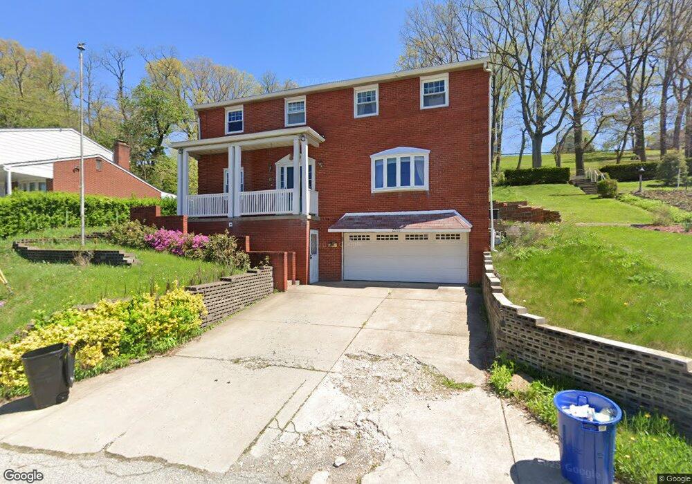
2203 Yale Dr Pittsburgh, PA 15210
Carrick NeighborhoodEstimated Value: $239,000 - $264,556
4
Beds
3
Baths
2,296
Sq Ft
$110/Sq Ft
Est. Value
About This Home
This home is located at 2203 Yale Dr, Pittsburgh, PA 15210 and is currently estimated at $251,639, approximately $109 per square foot. 2203 Yale Dr is a home located in Allegheny County with nearby schools including Pittsburgh Concord K-5, Pittsburgh South Brook, and Pittsburgh Carrick High School.
Ownership History
Date
Name
Owned For
Owner Type
Purchase Details
Closed on
Mar 2, 2022
Sold by
Porro Jeffrey J
Bought by
Grace Brian A
Current Estimated Value
Purchase Details
Closed on
Feb 25, 2022
Sold by
Porro Jeffrey J
Bought by
Grace Brian A
Purchase Details
Closed on
Apr 4, 2019
Sold by
Porro Shirlee L and Porro Jeffrey J
Bought by
Porro Jeffrey J
Purchase Details
Closed on
Sep 23, 2014
Sold by
Porro Shirlee L
Bought by
Porro Shirlee L and Porro Jeffrey J
Purchase Details
Closed on
May 8, 1964
Bought by
Porro Peter W and Porro Shirlee L
Create a Home Valuation Report for This Property
The Home Valuation Report is an in-depth analysis detailing your home's value as well as a comparison with similar homes in the area
Home Values in the Area
Average Home Value in this Area
Purchase History
| Date | Buyer | Sale Price | Title Company |
|---|---|---|---|
| Grace Brian A | $235,000 | -- | |
| Grace Brian A | $235,000 | -- | |
| Porro Jeffrey J | -- | None Available | |
| Porro Shirlee L | -- | -- | |
| Porro Peter W | -- | -- |
Source: Public Records
Tax History Compared to Growth
Tax History
| Year | Tax Paid | Tax Assessment Tax Assessment Total Assessment is a certain percentage of the fair market value that is determined by local assessors to be the total taxable value of land and additions on the property. | Land | Improvement |
|---|---|---|---|---|
| 2025 | $2,521 | $109,400 | $14,100 | $95,300 |
| 2024 | $2,521 | $109,400 | $14,100 | $95,300 |
| 2023 | $2,521 | $109,400 | $14,100 | $95,300 |
| 2022 | $2,078 | $91,400 | $14,100 | $77,300 |
| 2021 | $2,078 | $91,400 | $14,100 | $77,300 |
| 2020 | $2,068 | $91,400 | $14,100 | $77,300 |
| 2019 | $2,068 | $91,400 | $14,100 | $77,300 |
| 2018 | $1,566 | $91,400 | $14,100 | $77,300 |
| 2017 | $2,068 | $91,400 | $14,100 | $77,300 |
| 2016 | $432 | $91,400 | $14,100 | $77,300 |
| 2015 | $432 | $91,400 | $14,100 | $77,300 |
| 2014 | $2,023 | $91,400 | $14,100 | $77,300 |
Source: Public Records
Map
Nearby Homes
- 2211 Lucina Ave
- 404 Ariston Ave
- 400 Ariston Ave
- 2082 Walton Ave
- 331 Redwood St
- 309 Parkfield St
- 713 Maytide St
- 373 Copperfield Ave
- 1928 Dartmore St
- 2220 Jacob St
- 755 Maytide St
- 419 Maytide St
- 368 Maytide St
- 2020 Brownsville Rd
- 2382 Edgar St
- 2000 Brownsville Rd
- 21 Briggs St
- 53 Carrick Ave
- 2032 Jacob St
- 26 Carrick Ave