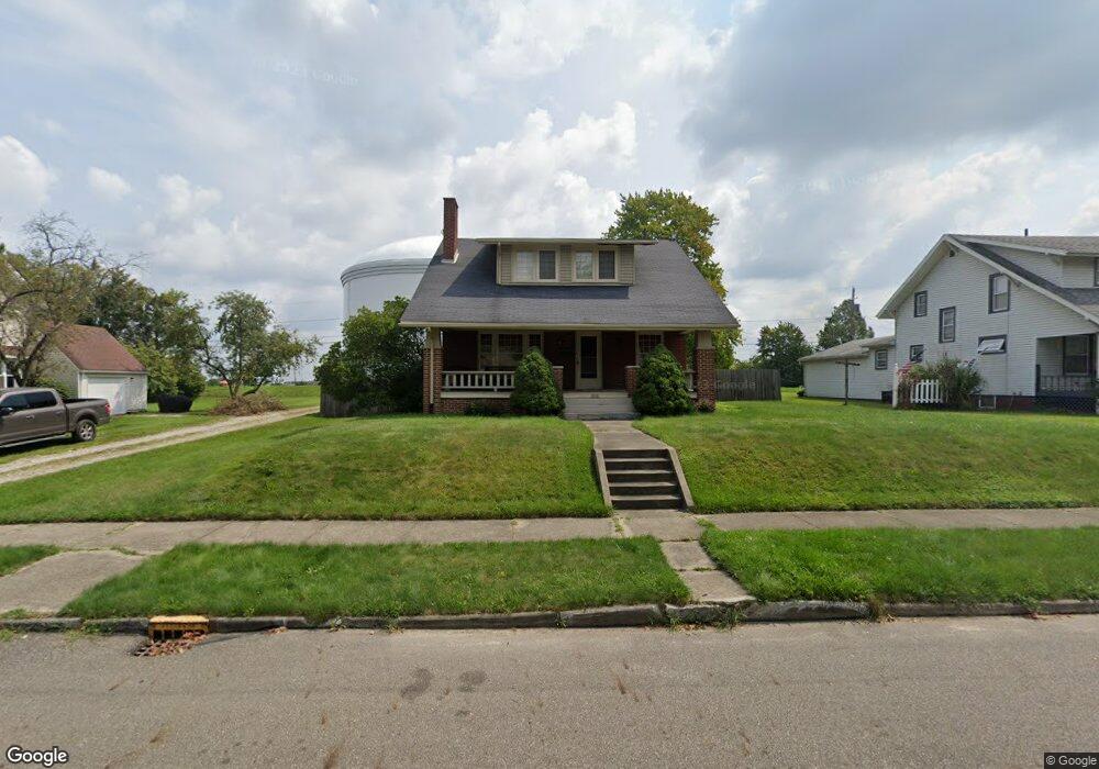
2208 Shunk Ave Alliance, OH 44601
Estimated Value: $175,000 - $204,000
3
Beds
2
Baths
1,470
Sq Ft
$129/Sq Ft
Est. Value
About This Home
This home is located at 2208 Shunk Ave, Alliance, OH 44601 and is currently estimated at $189,274, approximately $128 per square foot. 2208 Shunk Ave is a home located in Stark County with nearby schools including Alliance Elementary School at Rockhill, Alliance Intermediate School at Northside, and Alliance Middle School.
Ownership History
Date
Name
Owned For
Owner Type
Purchase Details
Closed on
Jun 2, 2008
Sold by
Frutos Ben V and Frutos Deborah A
Bought by
Kelley Gilbert G and Kelley Shanda L
Current Estimated Value
Home Financials for this Owner
Home Financials are based on the most recent Mortgage that was taken out on this home.
Original Mortgage
$95,501
Outstanding Balance
$60,906
Interest Rate
5.93%
Mortgage Type
FHA
Estimated Equity
$128,368
Purchase Details
Closed on
Nov 25, 1991
Create a Home Valuation Report for This Property
The Home Valuation Report is an in-depth analysis detailing your home's value as well as a comparison with similar homes in the area
Home Values in the Area
Average Home Value in this Area
Purchase History
| Date | Buyer | Sale Price | Title Company |
|---|---|---|---|
| Kelley Gilbert G | $97,000 | Heritage Union Title Co Ltd | |
| -- | $55,000 | -- |
Source: Public Records
Mortgage History
| Date | Status | Borrower | Loan Amount |
|---|---|---|---|
| Open | Kelley Gilbert G | $95,501 |
Source: Public Records
Tax History Compared to Growth
Tax History
| Year | Tax Paid | Tax Assessment Tax Assessment Total Assessment is a certain percentage of the fair market value that is determined by local assessors to be the total taxable value of land and additions on the property. | Land | Improvement |
|---|---|---|---|---|
| 2025 | -- | $54,320 | $12,110 | $42,210 |
| 2024 | -- | $54,320 | $12,110 | $42,210 |
| 2023 | $1,644 | $39,940 | $9,420 | $30,520 |
| 2022 | $1,655 | $39,940 | $9,420 | $30,520 |
| 2021 | $1,659 | $39,940 | $9,420 | $30,520 |
| 2020 | $1,566 | $35,210 | $8,190 | $27,020 |
| 2019 | $1,545 | $35,220 | $8,190 | $27,030 |
| 2018 | $1,553 | $35,220 | $8,190 | $27,030 |
| 2017 | $1,443 | $32,140 | $7,560 | $24,580 |
| 2016 | $1,410 | $31,160 | $7,560 | $23,600 |
| 2015 | $1,422 | $31,160 | $7,560 | $23,600 |
| 2014 | $1,324 | $28,390 | $6,900 | $21,490 |
| 2013 | $660 | $28,390 | $6,900 | $21,490 |
Source: Public Records
Map
Nearby Homes
- 2705 Shunk Ave
- 2372 S Union Ave
- 884 W College Rd
- 2405 Cherry Ave
- 2839 S Rockhill Ave
- 1515 S Rockhill Ave
- 549 Linwood Dr
- 112 E College St
- 1059 Oakwood Dr
- 236 E Milton St
- 317 E State St
- 2460 S Arch Ave
- 3101 Ridgehill Ave
- 1475 Chatauqua Ct
- 2408 S Linden Ave
- 2112 Blenheim Ave
- 1321 Parkway Blvd
- 390 E College St
- 2195 Blenheim Ave
- 2218 S Freedom Ave
- 2222 Shunk Ave
- 2148 Shunk Ave
- 2234 Shunk Ave
- 2138 Shunk Ave
- 2128 Shunk Ave
- 2246 Shunk Ave
- 2205 Shunk Ave
- 2211 Shunk Ave
- 2221 Shunk Ave
- 2233 Shunk Ave
- 2120 Shunk Ave
- 2237 Shunk Ave
- 2135 Shunk Ave
- 2245 Shunk Ave
- 2106 Shunk Ave
- 2121 Shunk Ave
- 2304 Shunk Ave
- 2224 Belleflower Dr
- 2152 Belleflower Dr
- 2236 Belleflower Dr