221 High St Duluth, MN 55811
Kenwood NeighborhoodEstimated Value: $436,543 - $506,000
3
Beds
3
Baths
2,269
Sq Ft
$205/Sq Ft
Est. Value
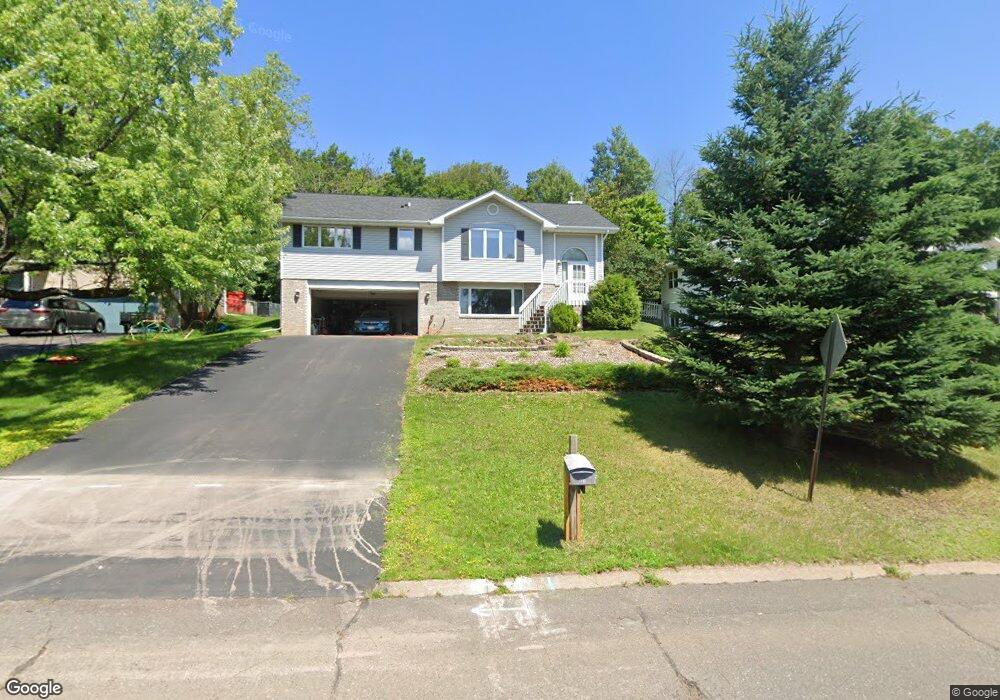
About This Home
This home is located at 221 High St, Duluth, MN 55811 and is currently estimated at $465,636, approximately $205 per square foot. 221 High St is a home located in St. Louis County with nearby schools including Lincoln Park Middle School, Denfeld High School, and Summit School.
Ownership History
Date
Name
Owned For
Owner Type
Purchase Details
Closed on
Feb 1, 2023
Sold by
Hoffman Cathleen L
Bought by
Hoffman Cathleen L and Hoffman Nicholas
Current Estimated Value
Purchase Details
Closed on
Dec 1, 2006
Sold by
Hansen Brian K
Bought by
Hoffman Cathleen
Home Financials for this Owner
Home Financials are based on the most recent Mortgage that was taken out on this home.
Original Mortgage
$65,000
Interest Rate
6.33%
Mortgage Type
Purchase Money Mortgage
Create a Home Valuation Report for This Property
The Home Valuation Report is an in-depth analysis detailing your home's value as well as a comparison with similar homes in the area
Home Values in the Area
Average Home Value in this Area
Purchase History
| Date | Buyer | Sale Price | Title Company |
|---|---|---|---|
| Hoffman Cathleen L | -- | None Listed On Document | |
| Hoffman Cathleen | $265,000 | Rels |
Source: Public Records
Mortgage History
| Date | Status | Borrower | Loan Amount |
|---|---|---|---|
| Previous Owner | Hoffman Cathleen | $65,000 |
Source: Public Records
Tax History
| Year | Tax Paid | Tax Assessment Tax Assessment Total Assessment is a certain percentage of the fair market value that is determined by local assessors to be the total taxable value of land and additions on the property. | Land | Improvement |
|---|---|---|---|---|
| 2024 | $5,236 | $391,800 | $56,100 | $335,700 |
| 2023 | $5,236 | $377,500 | $56,100 | $321,400 |
| 2022 | $5,300 | $349,600 | $52,200 | $297,400 |
| 2021 | $4,352 | $284,600 | $42,500 | $242,100 |
| 2020 | $4,230 | $279,800 | $42,500 | $237,300 |
| 2019 | $3,822 | $265,900 | $40,400 | $225,500 |
| 2018 | $3,456 | $244,700 | $40,400 | $204,300 |
| 2017 | $3,454 | $237,800 | $40,400 | $197,400 |
| 2016 | $3,376 | $3,900 | $3,900 | $0 |
| 2015 | $3,446 | $222,300 | $47,800 | $174,500 |
| 2014 | $3,446 | $222,300 | $47,800 | $174,500 |
Source: Public Records
Map
Nearby Homes
- 908 E Skyline Pkwy
- 1125 N 7th Ave E
- 1802 Rice Lake Rd
- 1804 Rice Lake Rd
- 1944 Chinook Dr
- 1011 N 12th Ave E
- XXX E Ninth St
- 1145 Como Ave Unit 1
- 917 E 7th St
- 409 E 6th St
- 609 N 4th Ave E
- 202 E 7th St Unit D
- 517 E 5th St
- 205 Bluff's Ridge Ct
- 1403 E 8th St
- 523 N 1st Ave E Unit 521
- 1030 Missouri Ave
- 722 E 3rd St
- 116 E Niagara St
- 419 N 13th Ave E
Your Personal Tour Guide
Ask me questions while you tour the home.