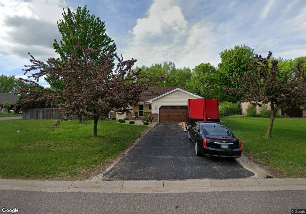
221 Robinhood Ln Circle Pines, MN 55014
Estimated Value: $395,000 - $400,000
3
Beds
2
Baths
1,099
Sq Ft
$362/Sq Ft
Est. Value
About This Home
This home is located at 221 Robinhood Ln, Circle Pines, MN 55014 and is currently estimated at $397,703, approximately $361 per square foot. 221 Robinhood Ln is a home located in Anoka County with nearby schools including Golden Lake Elementary School, Centennial Middle School, and Centennial High School.
Ownership History
Date
Name
Owned For
Owner Type
Purchase Details
Closed on
Jul 15, 2015
Sold by
Becker F F
Bought by
Kelly Robert Robert
Current Estimated Value
Home Financials for this Owner
Home Financials are based on the most recent Mortgage that was taken out on this home.
Original Mortgage
$230,743
Outstanding Balance
$181,044
Interest Rate
4.04%
Estimated Equity
$216,659
Purchase Details
Closed on
Jun 26, 1996
Sold by
Berenz John W and Berenz Beverly J
Bought by
Fitzpatrick John W and Hollister Karol
Create a Home Valuation Report for This Property
The Home Valuation Report is an in-depth analysis detailing your home's value as well as a comparison with similar homes in the area
Home Values in the Area
Average Home Value in this Area
Purchase History
| Date | Buyer | Sale Price | Title Company |
|---|---|---|---|
| Kelly Robert Robert | $235,000 | -- | |
| Fitzpatrick John W | $126,900 | -- |
Source: Public Records
Mortgage History
| Date | Status | Borrower | Loan Amount |
|---|---|---|---|
| Open | Kelly Robert Robert | $230,743 |
Source: Public Records
Tax History Compared to Growth
Tax History
| Year | Tax Paid | Tax Assessment Tax Assessment Total Assessment is a certain percentage of the fair market value that is determined by local assessors to be the total taxable value of land and additions on the property. | Land | Improvement |
|---|---|---|---|---|
| 2025 | $4,556 | $353,000 | $125,000 | $228,000 |
| 2024 | $4,556 | $342,200 | $115,000 | $227,200 |
| 2023 | $4,295 | $333,700 | $100,000 | $233,700 |
| 2022 | $4,048 | $334,300 | $90,000 | $244,300 |
| 2021 | $3,931 | $274,700 | $76,700 | $198,000 |
| 2020 | $3,966 | $261,000 | $76,700 | $184,300 |
| 2019 | $3,885 | $250,500 | $70,200 | $180,300 |
| 2018 | $3,446 | $232,100 | $0 | $0 |
| 2017 | $3,183 | $224,000 | $0 | $0 |
| 2016 | $3,411 | $205,600 | $0 | $0 |
| 2015 | $2,831 | $205,600 | $69,100 | $136,500 |
| 2014 | -- | $169,000 | $52,100 | $116,900 |
Source: Public Records
Map
Nearby Homes
- 8718 Ghia St NE
- 8823 Fraizer St
- 56 W Golden Lake Rd
- 5940 Fernwood St
- 343 Heritage Trail
- 1588 Hall St
- 319 Heritage Trail Unit 512
- 324 Heritage Trail
- 306 Heritage Trail
- 3811 Restwood Rd
- 9 Oak Leaf Ln
- 3 Golden Oak Dr
- 3667 91st Dr NE
- 1130 Lois Ct
- 3975 Lovell Rd
- 5986 Pheasant Dr
- 870 Sherwood Rd
- 1089 Serene Ct
- 868 Sherwood Rd
- 100 South Dr Unit E
- 223 Robinhood Ln
- 106 Canterbury Rd
- 222 Robinhood Ln
- 220 Robinhood Ln
- 224 Robinhood Ln
- 224R Robinhood Ln
- 108 Canterbury Rd
- 271 Little John Dr
- 273 Little John Dr
- 109 Canterbury Rd
- 107 Canterbury Rd
- 226 Robinhood Ln
- 105 Canterbury Rd
- 104 Canterbury Rd
- 275 Little John Dr
- 110 Canterbury Rd
- 113 Canterbury Rd
- 103 Canterbury Rd
- 277 Little John Dr
- 206 Marion Ct