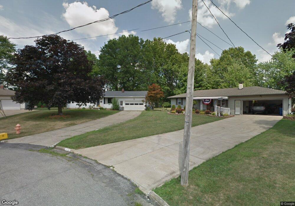
2217 Breezewood Dr Youngstown, OH 44515
Austintown NeighborhoodEstimated Value: $164,863 - $205,000
3
Beds
1
Bath
1,084
Sq Ft
$175/Sq Ft
Est. Value
About This Home
This home is located at 2217 Breezewood Dr, Youngstown, OH 44515 and is currently estimated at $189,966, approximately $175 per square foot. 2217 Breezewood Dr is a home located in Mahoning County with nearby schools including Austintown Elementary School, Austintown Intermediate School, and Austintown Middle School.
Ownership History
Date
Name
Owned For
Owner Type
Purchase Details
Closed on
Jun 20, 2007
Sold by
Florig Roland L and Florig Barbara M
Bought by
Andes Christopher J and Crincic Rebecca A
Current Estimated Value
Home Financials for this Owner
Home Financials are based on the most recent Mortgage that was taken out on this home.
Original Mortgage
$78,800
Outstanding Balance
$48,243
Interest Rate
6.2%
Mortgage Type
Purchase Money Mortgage
Estimated Equity
$141,723
Purchase Details
Closed on
May 23, 2001
Sold by
Florig Roland L and Florig B M
Bought by
Florig Roland L and Florig Barbara M
Purchase Details
Closed on
Jan 1, 1990
Bought by
Florig Roland L and B M
Create a Home Valuation Report for This Property
The Home Valuation Report is an in-depth analysis detailing your home's value as well as a comparison with similar homes in the area
Home Values in the Area
Average Home Value in this Area
Purchase History
| Date | Buyer | Sale Price | Title Company |
|---|---|---|---|
| Andes Christopher J | $98,500 | Commonwealth | |
| Florig Roland L | -- | -- | |
| Florig Roland L | -- | -- |
Source: Public Records
Mortgage History
| Date | Status | Borrower | Loan Amount |
|---|---|---|---|
| Open | Andes Christopher J | $78,800 |
Source: Public Records
Tax History Compared to Growth
Tax History
| Year | Tax Paid | Tax Assessment Tax Assessment Total Assessment is a certain percentage of the fair market value that is determined by local assessors to be the total taxable value of land and additions on the property. | Land | Improvement |
|---|---|---|---|---|
| 2024 | $1,996 | $43,590 | $9,110 | $34,480 |
| 2023 | $1,965 | $43,590 | $9,110 | $34,480 |
| 2022 | $1,705 | $30,330 | $8,150 | $22,180 |
| 2021 | $1,706 | $30,330 | $8,150 | $22,180 |
| 2020 | $1,713 | $30,330 | $8,150 | $22,180 |
| 2019 | $1,651 | $26,610 | $7,150 | $19,460 |
| 2018 | $1,589 | $26,610 | $7,150 | $19,460 |
| 2017 | $1,586 | $26,610 | $7,150 | $19,460 |
| 2016 | $1,636 | $27,190 | $8,040 | $19,150 |
| 2015 | $1,586 | $27,190 | $8,040 | $19,150 |
| 2014 | $1,594 | $27,190 | $8,040 | $19,150 |
| 2013 | $1,576 | $27,190 | $8,040 | $19,150 |
Source: Public Records
Map
Nearby Homes
- 2414 Ardenwood Place
- 2493 Frostwood Dr
- 4674 Barrington Dr
- 2388 Innwood Dr
- 1439 Bexley Dr
- 40 Woodleigh Ct
- 2211 Penny Ln
- 4289 Wedgewood Dr
- 4241 Wedgewood Dr
- 4235 Patricia Ave
- 1707 Westhampton Dr
- 4262 Pembrook Rd
- 4234 Burkey Rd
- 3348 Darbyshire Dr
- 2699 Hamman Dr
- 3913 Claridge Dr
- 5256 S Saratoga Ave
- 4102 Burkey Rd
- 5179 Willow Crest Ave
- 3890 Ayrshire Dr
- 2218 Breezewood Dr
- 2225 Breezewood Dr
- 4609 Crabwood Dr
- 4501 Crabwood Dr
- 2214 Frostwood Dr
- 4617 Crabwood Dr
- 2206 Frostwood Dr
- 2222 Frostwood Dr
- 2233 Breezewood Dr
- 2226 Breezewood Dr
- 4493 Crabwood Dr
- 2230 Frostwood Dr
- 4625 Crabwood Dr
- 2238 Frostwood Dr
- 2241 Breezewood Dr
- 4485 Crabwood Dr
- 2234 Breezewood Dr
- 4633 Crabwood Dr
- 2242 Breezewood Dr
- 2246 Frostwood Dr