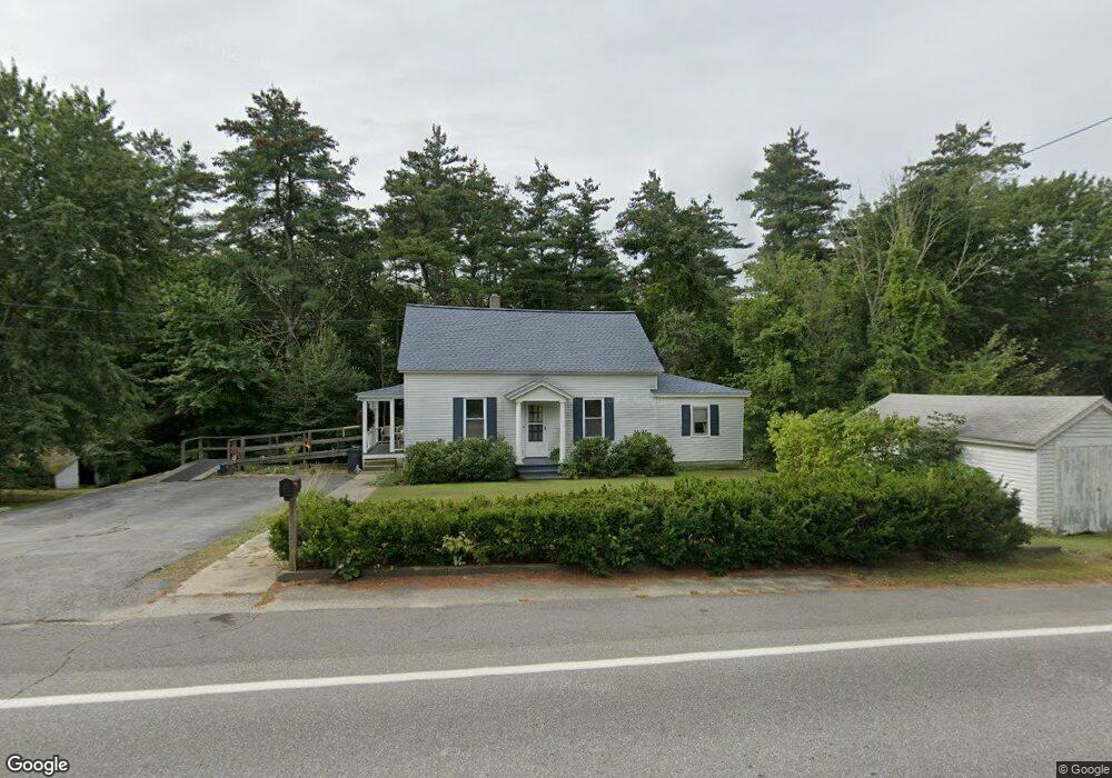
222 Goffstown Back Rd Goffstown, NH 03045
Estimated Value: $424,264 - $496,000
4
Beds
2
Baths
1,416
Sq Ft
$324/Sq Ft
Est. Value
About This Home
This home is located at 222 Goffstown Back Rd, Goffstown, NH 03045 and is currently estimated at $459,066, approximately $324 per square foot. 222 Goffstown Back Rd is a home with nearby schools including Mountain View Middle School, Goffstown High School, and Polaris Charter School.
Ownership History
Date
Name
Owned For
Owner Type
Purchase Details
Closed on
Jul 9, 2018
Sold by
Taber-Mccarthy Pamela J
Bought by
P J Taber-Mccarthy Ret
Current Estimated Value
Purchase Details
Closed on
Jul 31, 2007
Sold by
Wright Alfred T and Wright Erin M
Bought by
Taber-Mccarthy Pamela J
Home Financials for this Owner
Home Financials are based on the most recent Mortgage that was taken out on this home.
Original Mortgage
$184,000
Interest Rate
6.78%
Mortgage Type
Purchase Money Mortgage
Purchase Details
Closed on
Jan 31, 2003
Sold by
Groele David P
Bought by
Wright Alfred T and Wright Erin M
Home Financials for this Owner
Home Financials are based on the most recent Mortgage that was taken out on this home.
Original Mortgage
$175,000
Interest Rate
6.09%
Purchase Details
Closed on
Apr 3, 2002
Sold by
Clapp Terry Roger and Clapp David Edward
Bought by
Groele David P
Create a Home Valuation Report for This Property
The Home Valuation Report is an in-depth analysis detailing your home's value as well as a comparison with similar homes in the area
Home Values in the Area
Average Home Value in this Area
Purchase History
| Date | Buyer | Sale Price | Title Company |
|---|---|---|---|
| P J Taber-Mccarthy Ret | -- | -- | |
| Taber-Mccarthy Pamela J | $222,000 | -- | |
| Wright Alfred T | $175,000 | -- | |
| Groele David P | $154,900 | -- |
Source: Public Records
Mortgage History
| Date | Status | Borrower | Loan Amount |
|---|---|---|---|
| Previous Owner | Groele David P | $180,000 | |
| Previous Owner | Groele David P | $184,000 | |
| Previous Owner | Groele David P | $196,000 | |
| Previous Owner | Groele David P | $175,000 |
Source: Public Records
Tax History
| Year | Tax Paid | Tax Assessment Tax Assessment Total Assessment is a certain percentage of the fair market value that is determined by local assessors to be the total taxable value of land and additions on the property. | Land | Improvement |
|---|---|---|---|---|
| 2025 | $6,765 | $324,000 | $176,900 | $147,100 |
| 2024 | $6,623 | $324,000 | $176,900 | $147,100 |
| 2023 | $6,111 | $324,000 | $176,900 | $147,100 |
| 2022 | $5,425 | $206,200 | $115,100 | $91,100 |
| 2021 | $5,118 | $206,200 | $115,100 | $91,100 |
| 2020 | $5,118 | $206,200 | $115,100 | $91,100 |
| 2019 | $5,068 | $206,200 | $115,100 | $91,100 |
| 2018 | $3,835 | $206,200 | $115,100 | $91,100 |
| 2017 | $4,782 | $174,400 | $95,500 | $78,900 |
| 2016 | $4,609 | $174,400 | $95,500 | $78,900 |
| 2015 | $4,396 | $156,100 | $80,600 | $75,500 |
| 2014 | $4,304 | $159,400 | $80,600 | $78,800 |
Source: Public Records
Map
Nearby Homes
- 73 River Ledge Dr
- 11-1 Chatel Rd
- 6 Mustang Ct
- 19 My Way
- 179 Donald Dr
- 4B Dearborn Cir
- 11 E Dunbarton Rd
- 5B Dearborn Cir
- 3C Dearborn Cir
- 4C Dearborn Cir
- 3B Dearborn Cir
- 3A Dearborn Cir
- 0 Mast Rd Unit 49 5054665
- 2 Shore Dr
- 89 Moose Club Park Rd
- 3 Timberwood Dr Unit 301
- 114 Mast Rd
- 405 Upland St
- 36 English Village Rd Unit 202
- 19 Country Club Dr Unit 39
- 233 Goffstown Back Rd
- 225 Goffstown Back Rd
- 225a Goffstown Back Rd
- 225 Goffstown Back Rd Unit MAP 6 BLOCK-68
- 212 Goffstown Back Rd
- 235 Goffstown Back Rd
- 201 Goffstown Back Rd
- 245 Goffstown Back Rd Unit 245/4
- 250 Goffstown Back Rd
- 39 Roger Rd
- 10 Roger Rd
- 1 River Ledge Dr
- 31 River Ledge Dr
- 16 River Ledge Dr
- 49 Roger Rd
- 28 Roger Rd
- 22 Roger Rd
- 25 River Ledge Dr
- 41 Roger Rd
- 13 Roger Rd
Your Personal Tour Guide
Ask me questions while you tour the home.