2220 State Route 511 Perrysville, OH 44864
Estimated Value: $312,000 - $532,000
3
Beds
3
Baths
2,450
Sq Ft
$169/Sq Ft
Est. Value
About This Home
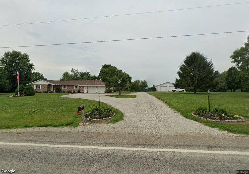
This home is located at 2220 State Route 511, Perrysville, OH 44864 and is currently estimated at $414,725, approximately $169 per square foot. 2220 State Route 511 is a home located in Ashland County with nearby schools including Hillsdale Elementary School, Hillsdale Middle School, and Hillsdale High School.
Ownership History
Date
Name
Owned For
Owner Type
Purchase Details
Closed on
Jan 12, 2022
Sold by
Berry Kenneth V and Berry Carolyn M
Bought by
Kenneth V And Carolyn M Berry Revocable Trust and Berry Carolyn
Current Estimated Value
Purchase Details
Closed on
Oct 13, 1992
Bought by
Berry Kenneth V
Create a Home Valuation Report for This Property
The Home Valuation Report is an in-depth analysis detailing your home's value as well as a comparison with similar homes in the area
Home Values in the Area
Average Home Value in this Area
Purchase History
| Date | Buyer | Sale Price | Title Company |
|---|---|---|---|
| Kenneth V And Carolyn M Berry Revocable Trust | -- | New Title Company Name | |
| Berry Kenneth V | $15,000 | -- |
Source: Public Records
Tax History Compared to Growth
Tax History
| Year | Tax Paid | Tax Assessment Tax Assessment Total Assessment is a certain percentage of the fair market value that is determined by local assessors to be the total taxable value of land and additions on the property. | Land | Improvement |
|---|---|---|---|---|
| 2024 | $3,611 | $120,570 | $27,840 | $92,730 |
| 2023 | $3,611 | $120,570 | $27,840 | $92,730 |
| 2022 | $3,060 | $83,150 | $19,200 | $63,950 |
| 2021 | $3,065 | $83,150 | $19,200 | $63,950 |
| 2020 | $2,869 | $83,150 | $19,200 | $63,950 |
| 2019 | $2,805 | $80,120 | $16,960 | $63,160 |
| 2018 | $2,788 | $80,120 | $16,960 | $63,160 |
| 2017 | $2,391 | $80,120 | $16,960 | $63,160 |
| 2016 | $2,391 | $69,670 | $14,750 | $54,920 |
| 2015 | $2,362 | $69,670 | $14,750 | $54,920 |
| 2013 | $2,823 | $80,250 | $14,960 | $65,290 |
Source: Public Records
Map
Nearby Homes
- 1048 Township Road 2156
- 0 Township Road 925
- 968 Township Road 2506
- 1106 County Road 30a
- 820 County Road 30a
- 1183 County Road 30a
- 19 Maine St
- 0 Applegate Rd
- 0 Mount Zion Rd Unit 9069748
- 2428 Applegate Rd
- 150 E Main St
- 0 Ashland County Road 2175
- 0 Ashland County Road 2175
- 0 Twp Rd 1806 Unit 11591470
- 609 Ohio 95
- 945 Pike Dr
- 560 Township Road 2402
- 1845 County Road 655
- 68.40 Acres Trumpower Rd
- 0 Trumpower Rd
- 2234 Ohio 511
- 2204 State Route 511
- 2240 State Route 511
- 2244 State Route 511
- 2193 State Route 511
- 994 Township Road 2206
- 2025 Ohio 511
- 2513 Ohio 511
- 2506 Ohio 511
- 0 Ohio 511
- 2193 Ohio 511
- 1016 County Road 2256
- 2189 Ohio 511
- 986 Township Road 2206
- 2189 State Route 511
- 2185 Ohio 511
- 2256 State Route 511
- 978 Township Road 2206
- 2185 State Route 511
- 2173 State Route 511