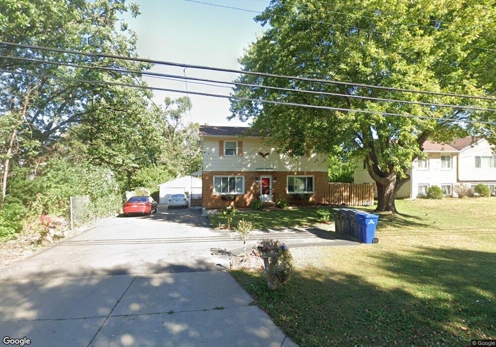
2227 Londin Ln E Saint Paul, MN 55119
Battle Creek NeighborhoodEstimated Value: $373,000 - $464,000
4
Beds
2
Baths
1,848
Sq Ft
$218/Sq Ft
Est. Value
About This Home
This home is located at 2227 Londin Ln E, Saint Paul, MN 55119 and is currently estimated at $403,334, approximately $218 per square foot. 2227 Londin Ln E is a home located in Ramsey County with nearby schools including Highwood Hills Elementary School, Battle Creek Middle School, and Harding Senior High School.
Ownership History
Date
Name
Owned For
Owner Type
Purchase Details
Closed on
Oct 2, 2023
Sold by
Lyons Richelle
Bought by
Mamai Norine and Rodriguez Robinson
Current Estimated Value
Home Financials for this Owner
Home Financials are based on the most recent Mortgage that was taken out on this home.
Original Mortgage
$370,125
Outstanding Balance
$362,806
Interest Rate
7.09%
Mortgage Type
New Conventional
Estimated Equity
$40,528
Purchase Details
Closed on
Feb 22, 2023
Sold by
Lyons Richelle
Bought by
Stearns Lending Llc
Purchase Details
Closed on
Nov 17, 2015
Sold by
Simons Shawn R and Simons Susan
Bought by
Lyons Richelle
Home Financials for this Owner
Home Financials are based on the most recent Mortgage that was taken out on this home.
Original Mortgage
$168,785
Interest Rate
3.62%
Mortgage Type
FHA
Purchase Details
Closed on
Oct 6, 1996
Sold by
Conoryea Dennis R and Conoryea Jean M
Bought by
Simons Shawn R
Create a Home Valuation Report for This Property
The Home Valuation Report is an in-depth analysis detailing your home's value as well as a comparison with similar homes in the area
Home Values in the Area
Average Home Value in this Area
Purchase History
| Date | Buyer | Sale Price | Title Company |
|---|---|---|---|
| Mamai Norine | $395,000 | -- | |
| Stearns Lending Llc | -- | -- | |
| Lyons Richelle | $171,900 | Title Recording Services Inc | |
| Simons Shawn R | $106,000 | -- |
Source: Public Records
Mortgage History
| Date | Status | Borrower | Loan Amount |
|---|---|---|---|
| Open | Mamai Norine | $370,125 | |
| Previous Owner | Lyons Richelle | $168,785 |
Source: Public Records
Tax History Compared to Growth
Tax History
| Year | Tax Paid | Tax Assessment Tax Assessment Total Assessment is a certain percentage of the fair market value that is determined by local assessors to be the total taxable value of land and additions on the property. | Land | Improvement |
|---|---|---|---|---|
| 2025 | $4,854 | $385,300 | $30,600 | $354,700 |
| 2023 | $4,854 | $308,700 | $30,600 | $278,100 |
| 2022 | $5,528 | $279,200 | $30,600 | $248,600 |
| 2021 | $4,344 | $260,200 | $30,600 | $229,600 |
| 2020 | $4,162 | $241,600 | $30,600 | $211,000 |
| 2019 | $2,888 | $219,600 | $30,600 | $189,000 |
| 2018 | $2,770 | $170,900 | $30,600 | $140,300 |
| 2017 | $2,898 | $170,900 | $30,600 | $140,300 |
| 2016 | $2,716 | $0 | $0 | $0 |
| 2015 | $2,628 | $158,200 | $30,600 | $127,600 |
| 2014 | $2,608 | $0 | $0 | $0 |
Source: Public Records
Map
Nearby Homes
- 2321 Pond Ave E Unit 36
- 2363 Dorland Ln E
- 2365 Dorland Ln E Unit 62
- 2445 Londin Ln E Unit 310
- 2169 Glenridge Ave
- 371, 377, 381 Totem Rd
- 408 Totem Rd
- 2250 Edgebrook Ave
- 2485 Londin Ln E Unit 323
- 2485 Londin Ln E Unit 418
- 567 Lakewood Dr S
- 2243 Edgebrook Ave
- 515 Marnie St S
- 2338 Hillwood Dr E
- 491 Burlington Rd
- 2219 Cardinal Place
- 479 Mary St S
- 38 Morningside Dr
- 688 Burlington Rd
- 0 Oakridge St
- 2225 Londin Ln E
- 2243 Londin Ln E
- 2217 Londin Ln E
- 367 Londin Place
- 368 Londin Cir
- 368 368 Londin-Circle-
- 351 Mcknight Rd S
- 2207 Londin Ln E
- 373 Londin Place
- 374 Londin Cir
- 368 Londin Place
- 331 Mcknight Rd S
- 381 Londin Place
- 374 Londin Place
- 380 Londin Cir
- 2195 Londin Ln E
- 367 Londin Cir
- 380 Londin Place
- 373 Londin Cir
- 385 Londin Place