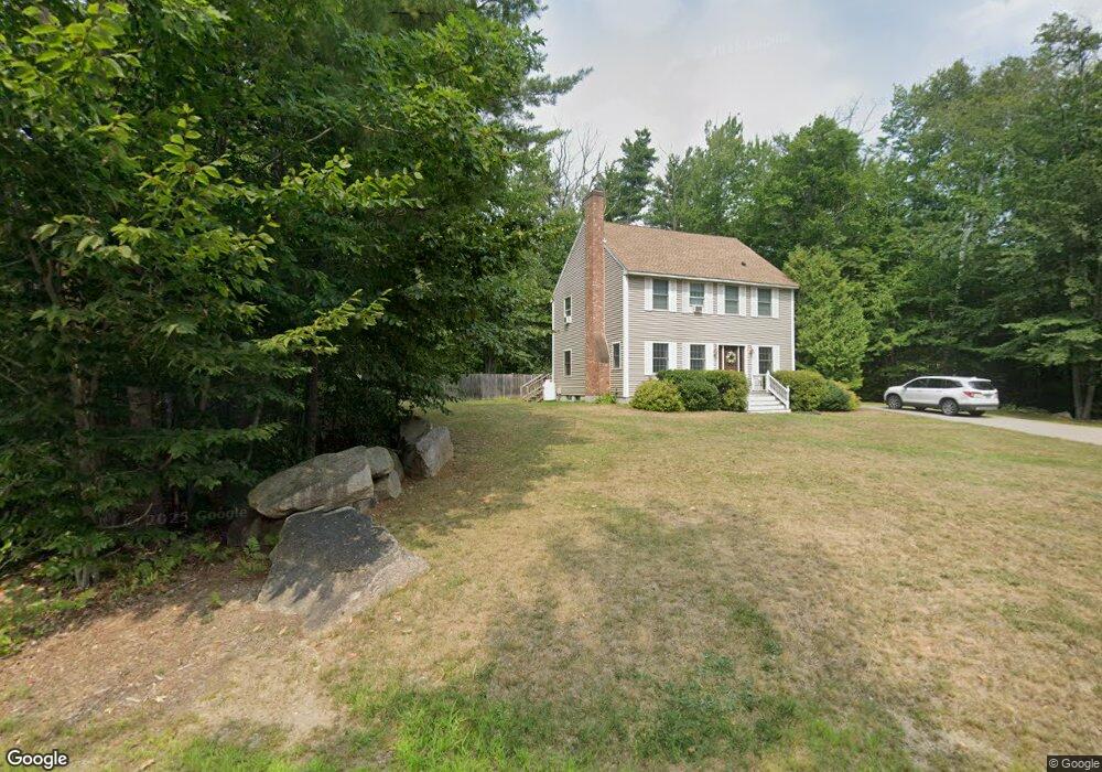
223 Wyman Ave Conway, NH 03818
Estimated Value: $617,000 - $711,000
3
Beds
3
Baths
2,192
Sq Ft
$304/Sq Ft
Est. Value
About This Home
This home is located at 223 Wyman Ave, Conway, NH 03818 and is currently estimated at $665,940, approximately $303 per square foot. 223 Wyman Ave is a home with nearby schools including A. Crosby Kennett Middle School, Kennett High School, and The Lilliputian School.
Ownership History
Date
Name
Owned For
Owner Type
Purchase Details
Closed on
Aug 15, 2006
Sold by
Rice Deborah
Bought by
Lees Scott J and Lees Christina F
Current Estimated Value
Home Financials for this Owner
Home Financials are based on the most recent Mortgage that was taken out on this home.
Original Mortgage
$243,630
Outstanding Balance
$146,589
Interest Rate
6.8%
Mortgage Type
Purchase Money Mortgage
Estimated Equity
$519,351
Create a Home Valuation Report for This Property
The Home Valuation Report is an in-depth analysis detailing your home's value as well as a comparison with similar homes in the area
Home Values in the Area
Average Home Value in this Area
Purchase History
| Date | Buyer | Sale Price | Title Company |
|---|---|---|---|
| Lees Scott J | $270,700 | -- |
Source: Public Records
Mortgage History
| Date | Status | Borrower | Loan Amount |
|---|---|---|---|
| Open | Lees Scott J | $243,630 |
Source: Public Records
Tax History Compared to Growth
Tax History
| Year | Tax Paid | Tax Assessment Tax Assessment Total Assessment is a certain percentage of the fair market value that is determined by local assessors to be the total taxable value of land and additions on the property. | Land | Improvement |
|---|---|---|---|---|
| 2024 | $6,436 | $561,100 | $158,500 | $402,600 |
| 2023 | $6,554 | $561,100 | $158,500 | $402,600 |
| 2022 | $5,276 | $269,200 | $80,600 | $188,600 |
| 2021 | $4,399 | $269,200 | $80,600 | $188,600 |
| 2020 | $4,547 | $269,200 | $80,600 | $188,600 |
| 2019 | $4,663 | $269,200 | $80,600 | $188,600 |
| 2018 | $4,607 | $202,500 | $60,600 | $141,900 |
| 2017 | $4,046 | $202,500 | $60,600 | $141,900 |
| 2016 | $3,910 | $202,500 | $60,600 | $141,900 |
| 2015 | $3,866 | $202,500 | $60,600 | $141,900 |
| 2014 | $3,819 | $202,500 | $60,600 | $141,900 |
| 2013 | $3,708 | $207,600 | $60,600 | $147,000 |
Source: Public Records
Map
Nearby Homes
- 46 Crestwood Dr
- 45 Wildflower Trail Unit 9
- 11 Intervale Outlook Cir Unit 3
- 23 Intervale Outlook Cir Unit 8
- 227 Alpstrausse
- 129 Dinsmore Rd
- 73 Dinsmore Rd
- 52 Hillside Ave
- 22 Eagle Ridge Condo Rd Unit 22
- 970 Kearsarge Rd
- 3465 White Mountain Hwy
- 00000 Ledgewood Rd
- 17 Purple Finch Rd Unit 73
- 3360 & 3378 White Mountain Hwy
- 135 Nh Rte 16 and 302 Hwy
- 679 Kearsarge Rd
- 50 Drachenfels Rd
- 2955 White Mountain Hwy Unit 106 (W5)
- 2955 White Mountain Hwy Unit 123 (E20)
- 2955 White Mountain Hwy Unit 204 W28
- 00 Wyman Ave
- 218 Hurricane Mountain Rd
- 76 Crestwood Dr
- 215 Wyman Ave
- 81 Crestwood Dr
- 7 Pendexter Woods Rd
- 4 Pendexter Woods Rd
- 172 Hurricane Mountain Rd
- 205 Hurricane Mountain Rd
- 23 Pendexter Woods Rd
- 7 Pendexter Woods Rd
- 210 Wyman Ave
- 23 Pendexter Woods Rd
- 197 Wyman Ave
- 76 Crestwood Dr
- 61 Crestwood Dr
- 4 Pendexter Woods Rd
- 37 Pendexter Woods Rd
- 47 Crestwood Dr
- 8 Pendexter Woods Rd