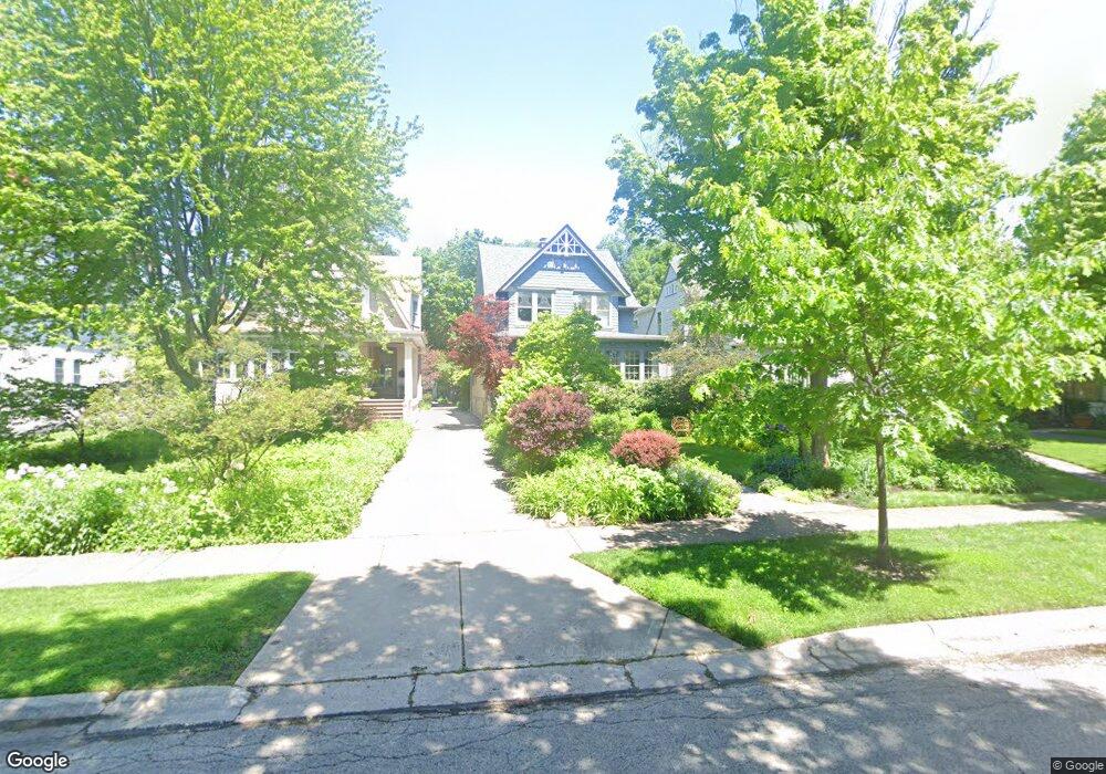
224 Herrick Rd Riverside, IL 60546
Estimated Value: $566,714 - $592,000
4
Beds
4
Baths
1,885
Sq Ft
$310/Sq Ft
Est. Value
About This Home
This home is located at 224 Herrick Rd, Riverside, IL 60546 and is currently estimated at $583,679, approximately $309 per square foot. 224 Herrick Rd is a home located in Cook County with nearby schools including Central Elementary School, L J Hauser Jr High School, and Riverside Brookfield High School.
Ownership History
Date
Name
Owned For
Owner Type
Purchase Details
Closed on
Oct 28, 1994
Sold by
Wills Elizabeth M and Wills David C
Bought by
Condon David J and Sellers Gail J
Current Estimated Value
Home Financials for this Owner
Home Financials are based on the most recent Mortgage that was taken out on this home.
Original Mortgage
$140,000
Interest Rate
8.75%
Create a Home Valuation Report for This Property
The Home Valuation Report is an in-depth analysis detailing your home's value as well as a comparison with similar homes in the area
Home Values in the Area
Average Home Value in this Area
Purchase History
| Date | Buyer | Sale Price | Title Company |
|---|---|---|---|
| Condon David J | $175,000 | -- |
Source: Public Records
Mortgage History
| Date | Status | Borrower | Loan Amount |
|---|---|---|---|
| Closed | Condon David J | $140,000 |
Source: Public Records
Tax History
| Year | Tax Paid | Tax Assessment Tax Assessment Total Assessment is a certain percentage of the fair market value that is determined by local assessors to be the total taxable value of land and additions on the property. | Land | Improvement |
|---|---|---|---|---|
| 2025 | $12,209 | $44,133 | $9,600 | $34,533 |
| 2024 | $12,209 | $44,133 | $9,600 | $34,533 |
| 2023 | $11,841 | $44,133 | $9,600 | $34,533 |
| 2022 | $11,841 | $37,072 | $8,400 | $28,672 |
| 2021 | $11,437 | $37,071 | $8,400 | $28,671 |
| 2020 | $12,226 | $39,927 | $8,400 | $31,527 |
| 2019 | $11,185 | $37,953 | $7,680 | $30,273 |
| 2018 | $9,272 | $37,953 | $7,680 | $30,273 |
| 2017 | $8,815 | $37,953 | $7,680 | $30,273 |
| 2016 | $10,679 | $34,605 | $6,720 | $27,885 |
| 2015 | $11,005 | $34,605 | $6,720 | $27,885 |
| 2014 | $10,835 | $34,605 | $6,720 | $27,885 |
| 2013 | $9,386 | $32,714 | $6,720 | $25,994 |
Source: Public Records
Map
Nearby Homes
- 269 Shenstone Rd
- 369 Addison Rd
- 10 E Burlington St Unit 2C
- 10 E Burlington St Unit 2B
- 231 Bartram Rd
- 280 Blackhawk Rd
- 176 Riverside Rd
- 475 Shenstone Rd Unit 104
- 475 Shenstone Rd Unit 304
- 475 Shenstone Rd Unit 303
- 484 Shenstone Rd
- 262 Lionel Rd
- 303 Lionel Rd
- 78 Pine Ave
- 478 Kent Rd
- 315 Bartram Rd
- 7048 35th St
- 101 Southcote Rd
- 305 Desplaines Ave
- 220 Maplewood Rd
- 228 Herrick Rd
- 222 Herrick Rd
- 230 Herrick Rd
- 218 Herrick Rd Unit 3
- 218 Herrick Rd
- 218 Herrick Rd Unit 2
- 234 Herrick Rd
- 212 Herrick Rd
- 238 Herrick Rd
- 243 Addison Rd
- 239 Addison Rd
- 206 Herrick Rd
- 235 Addison Rd
- 231 Addison Rd
- 255 Addison Rd
- 242 Herrick Rd
- 242 Herrick Rd
- 225 Herrick Rd
- 229 Herrick Rd
- 221 Herrick Rd
Your Personal Tour Guide
Ask me questions while you tour the home.