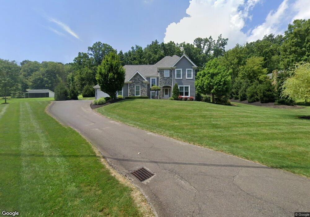
224 Hespenheide Rd Mars, PA 16046
Adams Township NeighborhoodEstimated Value: $702,000 - $791,000
3
Beds
3
Baths
2,938
Sq Ft
$249/Sq Ft
Est. Value
About This Home
This home is located at 224 Hespenheide Rd, Mars, PA 16046 and is currently estimated at $732,333, approximately $249 per square foot. 224 Hespenheide Rd is a home with nearby schools including Mars Area Primary Center, Mars Area Elementary School, and Mars Area Centennial School.
Ownership History
Date
Name
Owned For
Owner Type
Purchase Details
Closed on
Jan 19, 2017
Sold by
Koch Construction Co Inc
Bought by
Platt Christopher H
Current Estimated Value
Purchase Details
Closed on
Sep 22, 2016
Sold by
Dewey Ryan C and Dewey Elissa
Bought by
Koch Construction Co Inc
Purchase Details
Closed on
Mar 28, 2012
Sold by
Estate Of Gerald Kossar
Bought by
Dewey Ryan C
Create a Home Valuation Report for This Property
The Home Valuation Report is an in-depth analysis detailing your home's value as well as a comparison with similar homes in the area
Home Values in the Area
Average Home Value in this Area
Purchase History
| Date | Buyer | Sale Price | Title Company |
|---|---|---|---|
| Platt Christopher H | $130,000 | American General Svcs Corp | |
| Koch Construction Co Inc | $121,000 | American General Serv Corp | |
| Dewey Ryan C | $13,200 | -- |
Source: Public Records
Tax History Compared to Growth
Tax History
| Year | Tax Paid | Tax Assessment Tax Assessment Total Assessment is a certain percentage of the fair market value that is determined by local assessors to be the total taxable value of land and additions on the property. | Land | Improvement |
|---|---|---|---|---|
| 2025 | $5,284 | $37,640 | $900 | $36,740 |
| 2024 | $5,153 | $37,640 | $900 | $36,740 |
| 2023 | $4,997 | $37,640 | $900 | $36,740 |
| 2022 | $4,997 | $37,640 | $900 | $36,740 |
| 2021 | $4,997 | $37,640 | $0 | $0 |
| 2020 | $4,664 | $35,130 | $900 | $34,230 |
| 2019 | $4,664 | $35,130 | $900 | $34,230 |
| 2018 | $4,580 | $35,130 | $900 | $34,230 |
| 2017 | $117 | $900 | $900 | $0 |
| 2016 | $31 | $900 | $900 | $0 |
| 2015 | $18 | $900 | $900 | $0 |
| 2014 | $18 | $900 | $900 | $0 |
Source: Public Records
Map
Nearby Homes
- 104 Broadstone Dr
- 313 Crest Ln
- 327 Crest Ln
- 114 Southern Valley Ct
- 240 Broadstone Dr
- 713 Norwegian Spruce Dr
- 543 Juniper Ct
- 805 Mount Pleasant Rd
- 1010 Alpine Dr
- 1304 Pointe View Dr
- 121 Hillvue Dr
- 809 Mount Pleasant Rd
- 1703 Pointe View Dr
- 162 Woodhaven Dr
- 3001 Pointe View Dr
- 117 Minnock Dr
- 2104 Pointe View Dr
- 212 Cumberland Dr
- 238 Cumberland Dr
- 7002 Eagle Rd
- 230 Hespenheide Rd
- 218 Hespenheide Rd
- 361 Crest Ln
- 363 Crest Ln
- 242 Hespenheide Rd
- 359 Crest Ln
- 236 Hespenheide Rd
- 354 Crest Ln
- 357 Crest Ln
- 352 Crest Ln
- 355 Crest Ln
- 350 Crest Ln
- 111 Broadstone Dr
- 117 Broadstone Dr
- 103 Broadstone Dr
- 348 Crest Ln
- 109 Broadstone Dr
- 115 Broadstone Dr
- 113 Broadstone Dr
- 107 Broadstone Dr