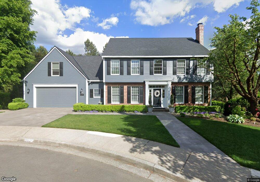
22420 Mckenzie Ct West Linn, OR 97068
Tanner Basin NeighborhoodEstimated Value: $1,145,473 - $1,663,000
--
Bed
3
Baths
5,403
Sq Ft
$243/Sq Ft
Est. Value
About This Home
This home is located at 22420 Mckenzie Ct, West Linn, OR 97068 and is currently estimated at $1,314,868, approximately $243 per square foot. 22420 Mckenzie Ct is a home located in Clackamas County with nearby schools including Sunset Primary School, Rosemont Ridge Middle School, and West Linn High School.
Ownership History
Date
Name
Owned For
Owner Type
Purchase Details
Closed on
Mar 22, 2024
Sold by
Cook Steven D and Cook Judith M
Bought by
Steven D Cook And Judith M Cook Joint Trust and Cook
Current Estimated Value
Purchase Details
Closed on
Apr 1, 1993
Bought by
Cook Steven D and Cook Judith M
Create a Home Valuation Report for This Property
The Home Valuation Report is an in-depth analysis detailing your home's value as well as a comparison with similar homes in the area
Home Values in the Area
Average Home Value in this Area
Purchase History
| Date | Buyer | Sale Price | Title Company |
|---|---|---|---|
| Steven D Cook And Judith M Cook Joint Trust | -- | None Listed On Document | |
| Steven D Cook And Judith M Cook Joint Trust | -- | None Listed On Document | |
| Cook Steven D | $73,400 | -- |
Source: Public Records
Tax History Compared to Growth
Tax History
| Year | Tax Paid | Tax Assessment Tax Assessment Total Assessment is a certain percentage of the fair market value that is determined by local assessors to be the total taxable value of land and additions on the property. | Land | Improvement |
|---|---|---|---|---|
| 2025 | $12,759 | $662,063 | -- | -- |
| 2024 | $12,281 | $642,780 | -- | -- |
| 2023 | $12,281 | $624,059 | $0 | $0 |
| 2022 | $11,592 | $605,883 | $0 | $0 |
| 2021 | $10,733 | $588,236 | $0 | $0 |
| 2020 | $10,631 | $571,103 | $0 | $0 |
| 2019 | $10,188 | $554,469 | $0 | $0 |
| 2018 | $9,682 | $538,319 | $0 | $0 |
| 2017 | $9,212 | $522,640 | $0 | $0 |
| 2016 | $8,821 | $507,417 | $0 | $0 |
| 2015 | $8,425 | $492,638 | $0 | $0 |
| 2014 | $7,973 | $478,289 | $0 | $0 |
Source: Public Records
Map
Nearby Homes
- 3115 Sabo Ln
- 3296 Nomie Way
- 3249 Wild Rose Loop
- 2625 Beacon Hill Dr
- 3933 Parker Rd
- 3496 Chaparrel Loop
- 2650 Lorinda Ln
- 2762 Dahlia Dr
- 3492 Vista Ridge Dr
- 4057 Heron Dr
- 1470 Rosemont Rd
- 20349 Noble Ln
- 2025 De Vries Way
- 4194 Cornwall St
- 4192 Cornwall St
- 4190 Cornwall St
- 4110 Cornwall St
- 20322 Noble Ln
- 3776 Landis St
- 4147 Cornwall St
- 22400 Mckenzie Ct
- 3375 Crescent Dr
- 22460 Mckenzie Ct
- 3395 Crescent Dr
- 3415 Crescent Dr
- 3355 Crescent Dr
- 22401 Mckenzie Ct
- 22441 Mckenzie Ct
- 3112 Sabo Ln
- 3108 Sabo Ln
- 3124 Sabo Ln
- 22421 Mckenzie Ct
- 22461 Mckenzie Ct
- 3100 Sabo Ln
- 3390 Crescent Dr
- 2510 Beacon Hill Dr
- 3422 Crescent Dr
- 3390 Quail Ridge Ct
- 3148 Sabo Ln
- 22430 Ponderay Dr