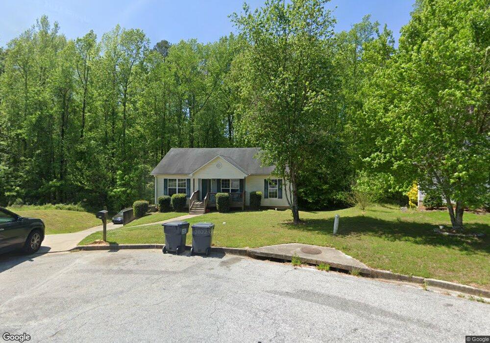
225 Railside Dr Covington, GA 30014
Estimated Value: $256,000 - $289,114
4
Beds
3
Baths
1,661
Sq Ft
$160/Sq Ft
Est. Value
About This Home
This home is located at 225 Railside Dr, Covington, GA 30014 and is currently estimated at $266,279, approximately $160 per square foot. 225 Railside Dr is a home located in Newton County with nearby schools including Heard-Mixon Elementary School, Cousins Middle School, and Eastside High School.
Ownership History
Date
Name
Owned For
Owner Type
Purchase Details
Closed on
Nov 30, 2010
Sold by
Skillman Tanya and Skillman Kevin
Bought by
Cowan Barry
Current Estimated Value
Purchase Details
Closed on
Nov 30, 2007
Sold by
R & B Const Inc
Bought by
Skillman Tanya and Skillman Kevin
Home Financials for this Owner
Home Financials are based on the most recent Mortgage that was taken out on this home.
Original Mortgage
$131,431
Interest Rate
6.22%
Mortgage Type
New Conventional
Create a Home Valuation Report for This Property
The Home Valuation Report is an in-depth analysis detailing your home's value as well as a comparison with similar homes in the area
Home Values in the Area
Average Home Value in this Area
Purchase History
| Date | Buyer | Sale Price | Title Company |
|---|---|---|---|
| Cowan Barry | $50,000 | -- | |
| Skillman Tanya | $138,400 | -- |
Source: Public Records
Mortgage History
| Date | Status | Borrower | Loan Amount |
|---|---|---|---|
| Previous Owner | Skillman Tanya | $131,431 |
Source: Public Records
Tax History
| Year | Tax Paid | Tax Assessment Tax Assessment Total Assessment is a certain percentage of the fair market value that is determined by local assessors to be the total taxable value of land and additions on the property. | Land | Improvement |
|---|---|---|---|---|
| 2025 | $3,243 | $127,440 | $15,200 | $112,240 |
| 2024 | $3,090 | $119,120 | $15,200 | $103,920 |
| 2023 | $3,084 | $111,000 | $6,400 | $104,600 |
| 2022 | $2,325 | $83,040 | $6,400 | $76,640 |
| 2021 | $2,228 | $71,080 | $6,400 | $64,680 |
| 2020 | $2,026 | $58,200 | $6,400 | $51,800 |
| 2019 | $1,639 | $46,000 | $6,400 | $39,600 |
| 2018 | $1,288 | $35,480 | $5,000 | $30,480 |
| 2017 | $1,218 | $33,440 | $3,800 | $29,640 |
| 2016 | $1,242 | $34,120 | $3,800 | $30,320 |
| 2015 | $1,192 | $32,720 | $3,200 | $29,520 |
| 2014 | $1,309 | $32,720 | $0 | $0 |
Source: Public Records
Map
Nearby Homes
- 25 Scarlett Ct
- 10717 Highway 36
- 324 Piper Rd
- 13268 Tolstoy Ln
- 0 Piper Rd Unit 7693971
- 0 Piper Rd Unit 10659921
- 20 Kestrel Cir
- 370 Granary Walk
- 18 River Walk Farm Pkwy
- 85 Bellerive Ln SE
- 10184 Malcolm Dr
- 60 Laurie Ln
- 7713 Fawn Cir
- 7713 Fawn Cir Unit 51
- 7703 Fawn Cir
- 200 Hidden Pines Dr
- 10110 Malcolm Ct
- 25 Lena Ct
- 35 Crossbill Trail
- 170 Hidden Pines Dr
- 220 Railside Dr
- 215 Railside Dr
- 210 Railside Dr
- 45 Boxcar Ln
- 200 Railside Dr
- 190 Railside Dr
- 195 Railside Dr
- 110 Cedar Creek Dr
- 35 Boxcar Ln
- 105 Cedar Creek Dr
- 35 Sunbelt Pkwy
- 30 Boxcar Ln
- 180 Railside Dr
- 175 Railside Dr
- 100 Cedar Creek Dr Unit 1
- 25 Boxcar Ln
- 95 Cedar Creek Dr Unit 1
- 170 Railside Dr
- 25 Sunbelt Pkwy Unit 25B, C; 35 B
- 25 Sunbelt Pkwy
Your Personal Tour Guide
Ask me questions while you tour the home.