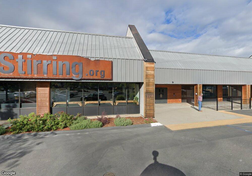
2250 Churn Creek Rd Redding, CA 96002
Studio
72
Baths
24,739
Sq Ft
66,211
Sq Ft
About This Home
This home is located at 2250 Churn Creek Rd, Redding, CA 96002. 2250 Churn Creek Rd is a home located in Shasta County with nearby schools including Mistletoe Elementary School, Enterprise High School, and Redding Collegiate Academy.
Ownership History
Date
Name
Owned For
Owner Type
Purchase Details
Closed on
Jun 22, 2010
Sold by
Ewart Ann L
Bought by
The Stirring Of The Christian & Missiona
Home Financials for this Owner
Home Financials are based on the most recent Mortgage that was taken out on this home.
Original Mortgage
$1,962,000
Outstanding Balance
$1,311,060
Interest Rate
4.91%
Mortgage Type
Commercial
Purchase Details
Closed on
Jun 28, 2001
Sold by
Ewart Walter F and Ewart Ann L
Bought by
Ewart Walter F and Ewart Ann L
Create a Home Valuation Report for This Property
The Home Valuation Report is an in-depth analysis detailing your home's value as well as a comparison with similar homes in the area
Purchase History
| Date | Buyer | Sale Price | Title Company |
|---|---|---|---|
| The Stirring Of The Christian & Missiona | $1,625,000 | Fidelity Natl Title Co Of Ca | |
| Ewart Walter F | -- | -- |
Source: Public Records
Mortgage History
| Date | Status | Borrower | Loan Amount |
|---|---|---|---|
| Open | The Stirring Of The Christian & Missiona | $1,962,000 |
Source: Public Records
Tax History
| Year | Tax Paid | Tax Assessment Tax Assessment Total Assessment is a certain percentage of the fair market value that is determined by local assessors to be the total taxable value of land and additions on the property. | Land | Improvement |
|---|---|---|---|---|
| 2025 | $1,855 | $3,065,591 | $322,697 | $2,742,894 |
| 2024 | $1,832 | $3,001,284 | $316,370 | $2,684,914 |
| 2023 | $1,832 | $2,927,285 | $310,167 | $2,617,118 |
| 2022 | $1,788 | $2,851,393 | $304,086 | $2,547,307 |
| 2021 | $3,073 | $2,767,284 | $298,124 | $2,469,160 |
| 2020 | $3,145 | $2,746,665 | $295,068 | $2,451,597 |
| 2019 | $3,271 | $2,706,434 | $289,283 | $2,417,151 |
| 2018 | $3,408 | $2,668,878 | $283,611 | $2,385,267 |
| 2017 | $3,653 | $2,633,008 | $278,050 | $2,354,958 |
| 2016 | $3,703 | $2,605,945 | $272,599 | $2,333,346 |
| 2015 | $3,606 | $2,579,485 | $268,505 | $2,310,980 |
| 2014 | $3,698 | $2,549,967 | $263,246 | $2,286,721 |
Source: Public Records
Map
Nearby Homes
- 1968 Bechelli Ln
- 918 Parsons Dr
- 0 Churn Creek Rd Unit 25-496
- 0 Churn Creek Rd Unit 26-609
- 0 Churn Creek Rd Unit 25-5491
- 2820 Alfreda Way
- 1939 Cameo Ct
- 550 Parsons Dr
- 1556 Minor St
- 1701 E Cypress Ave
- 2906 Regal Ave
- 1075 Le Brun Ln
- 2093 Victor Ave
- 3178 Lawrence Rd
- 350 Park Marina Cir
- 2590 Henderson Rd
- 1877 Wheeler St
- 2284 Paris Ave
- 1108 4th St
- 3428 Adams Ln
- 2305 Larkspur Ln
- 2223 Larkspur Ln
- 2223 Larkspur Ln
- 942 Merchant St
- 930 Merchant St
- 940 Merchant St
- 940 Merchant St
- 944 Merchant St
- 946 Merchant St
- 2225 Larkspur Ln
- 2313 Larkspur Ln
- 2200 Churn Creek Rd
- 915 Industrail St Indus
- 915 Industrial St
- 948 Merchant St
- 5025 Industrial St
- 1400 Industrial St
- 0 Industrial St
- 123456 Larkspur Ln
- 2245 Churn Creek Rd
Your Personal Tour Guide
Ask me questions while you tour the home.