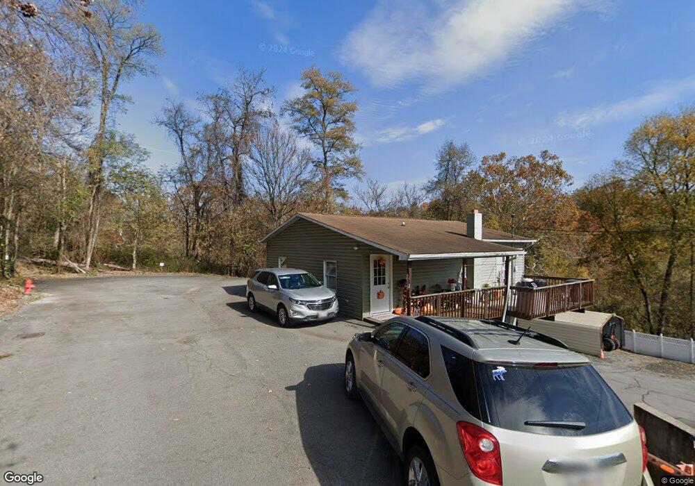
226 Dale St Hancock, MD 21750
Estimated Value: $214,000 - $252,000
--
Bed
1
Bath
958
Sq Ft
$237/Sq Ft
Est. Value
About This Home
This home is located at 226 Dale St, Hancock, MD 21750 and is currently estimated at $226,636, approximately $236 per square foot. 226 Dale St is a home located in Washington County with nearby schools including Hancock Elementary School and Hancock Middle Senior High School.
Ownership History
Date
Name
Owned For
Owner Type
Purchase Details
Closed on
Sep 4, 1992
Sold by
Lanehart Roland E
Bought by
Lanehart Roland E and Lanehart Melissa D
Current Estimated Value
Home Financials for this Owner
Home Financials are based on the most recent Mortgage that was taken out on this home.
Original Mortgage
$75,000
Interest Rate
7.94%
Purchase Details
Closed on
Jun 20, 1986
Sold by
Lanehart Roland E
Bought by
Lanehart Roland E
Home Financials for this Owner
Home Financials are based on the most recent Mortgage that was taken out on this home.
Original Mortgage
$95,000
Interest Rate
10.61%
Create a Home Valuation Report for This Property
The Home Valuation Report is an in-depth analysis detailing your home's value as well as a comparison with similar homes in the area
Home Values in the Area
Average Home Value in this Area
Purchase History
| Date | Buyer | Sale Price | Title Company |
|---|---|---|---|
| Lanehart Roland E | $75,000 | -- | |
| Lanehart Roland E | $107,000 | -- |
Source: Public Records
Mortgage History
| Date | Status | Borrower | Loan Amount |
|---|---|---|---|
| Closed | Lanehart Roland E | $75,000 | |
| Previous Owner | Lanehart Roland E | $95,000 |
Source: Public Records
Tax History Compared to Growth
Tax History
| Year | Tax Paid | Tax Assessment Tax Assessment Total Assessment is a certain percentage of the fair market value that is determined by local assessors to be the total taxable value of land and additions on the property. | Land | Improvement |
|---|---|---|---|---|
| 2025 | $1,548 | $198,600 | $0 | $0 |
| 2024 | $1,548 | $169,900 | $0 | $0 |
| 2023 | $1,286 | $141,200 | $54,800 | $86,400 |
| 2022 | $1,286 | $141,200 | $54,800 | $86,400 |
| 2021 | $1,365 | $141,200 | $54,800 | $86,400 |
| 2020 | $1,365 | $146,600 | $54,800 | $91,800 |
| 2019 | $1,371 | $146,600 | $54,800 | $91,800 |
| 2018 | $1,371 | $146,600 | $54,800 | $91,800 |
| 2017 | $1,388 | $148,400 | $0 | $0 |
| 2016 | -- | $147,333 | $0 | $0 |
| 2015 | -- | $146,267 | $0 | $0 |
| 2014 | $1,481 | $145,200 | $0 | $0 |
Source: Public Records
Map
Nearby Homes
- 214 Jackson St
- 29 Parrell St
- 216 Maryland Ave
- 32 Taliaferro St
- 145 E Main St
- 5 Brent St
- 13 Taliaferro St
- 109 W High St
- 0 Fulton St
- 0 S Pennsylvania Ave
- 12 N Church St
- 102 E Main St
- 5386 Pious Ridge Rd
- 14300 Tollgate Ridge
- 667 Thompson Rd
- 3659 Fairview Dr
- 0 Forever View Ln Unit WVMO2005358
- 170 Horseshoe Dr
- 156 Potomac View Ln
- 4014 Resley Rd