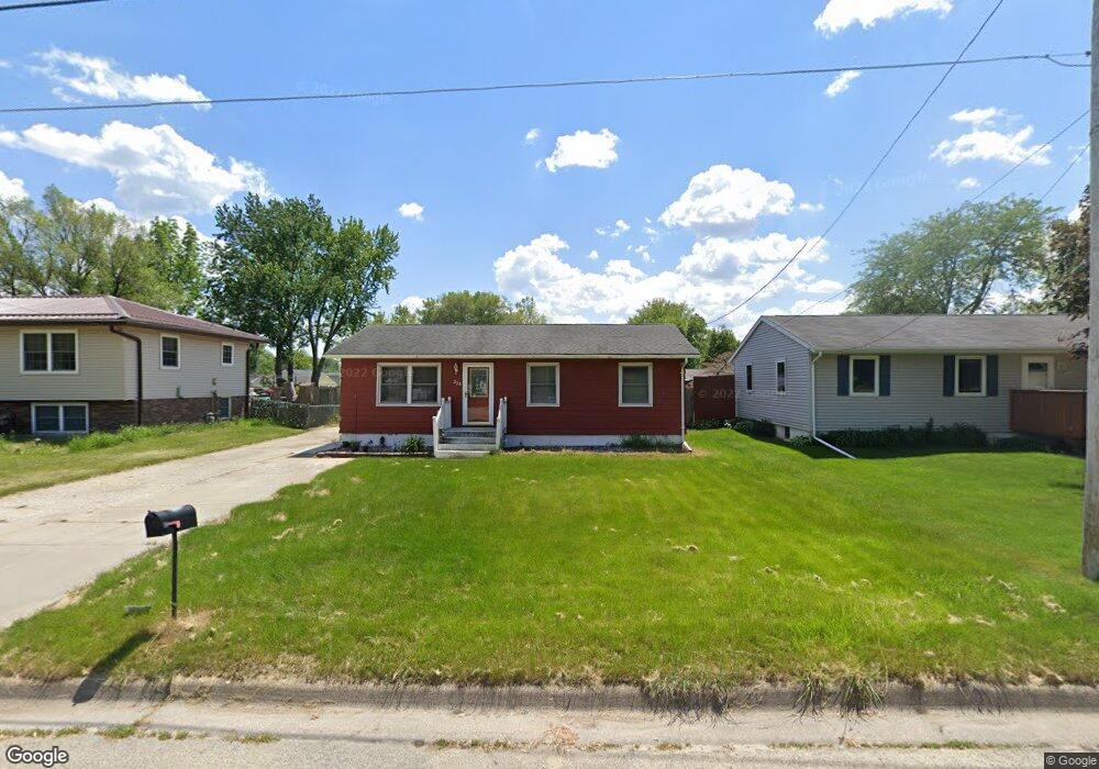
226 Leonard Ave Evansdale, IA 50707
Estimated Value: $177,000 - $191,000
3
Beds
2
Baths
1,612
Sq Ft
$114/Sq Ft
Est. Value
About This Home
This home is located at 226 Leonard Ave, Evansdale, IA 50707 and is currently estimated at $183,120, approximately $113 per square foot. 226 Leonard Ave is a home located in Black Hawk County with nearby schools including Poyner Elementary School, Bunger Middle School, and East High School.
Ownership History
Date
Name
Owned For
Owner Type
Purchase Details
Closed on
Sep 1, 2021
Sold by
Richard Daniel S
Bought by
Quail Myranda K
Current Estimated Value
Home Financials for this Owner
Home Financials are based on the most recent Mortgage that was taken out on this home.
Original Mortgage
$129,600
Outstanding Balance
$120,453
Interest Rate
4.37%
Mortgage Type
New Conventional
Estimated Equity
$62,667
Purchase Details
Closed on
Apr 2, 2015
Sold by
Skinner Thomas C and Skinner Bridgette C
Bought by
Quail Myranda K and Quail Richard Daniel
Home Financials for this Owner
Home Financials are based on the most recent Mortgage that was taken out on this home.
Original Mortgage
$12,500
Interest Rate
3.73%
Mortgage Type
Closed End Mortgage
Create a Home Valuation Report for This Property
The Home Valuation Report is an in-depth analysis detailing your home's value as well as a comparison with similar homes in the area
Home Values in the Area
Average Home Value in this Area
Purchase History
| Date | Buyer | Sale Price | Title Company |
|---|---|---|---|
| Quail Myranda K | -- | None Available | |
| Quail Myranda K | $125,000 | None Available |
Source: Public Records
Mortgage History
| Date | Status | Borrower | Loan Amount |
|---|---|---|---|
| Open | Quail Myranda K | $129,600 | |
| Previous Owner | Quail Myranda K | $12,500 | |
| Previous Owner | Quail Myranda K | $112,500 |
Source: Public Records
Tax History Compared to Growth
Tax History
| Year | Tax Paid | Tax Assessment Tax Assessment Total Assessment is a certain percentage of the fair market value that is determined by local assessors to be the total taxable value of land and additions on the property. | Land | Improvement |
|---|---|---|---|---|
| 2024 | $2,174 | $143,530 | $15,050 | $128,480 |
| 2023 | $1,726 | $143,530 | $15,050 | $128,480 |
| 2022 | $1,714 | $111,110 | $15,050 | $96,060 |
| 2021 | $1,738 | $111,110 | $15,050 | $96,060 |
| 2020 | $1,726 | $104,540 | $13,540 | $91,000 |
| 2019 | $1,726 | $104,540 | $13,540 | $91,000 |
| 2018 | $1,786 | $104,540 | $13,540 | $91,000 |
| 2017 | $1,804 | $104,540 | $13,540 | $91,000 |
| 2016 | $1,780 | $104,540 | $13,540 | $91,000 |
| 2015 | $1,780 | $104,540 | $13,540 | $91,000 |
| 2014 | $1,554 | $99,480 | $13,540 | $85,940 |
Source: Public Records
Map
Nearby Homes
- 222 Leonard Ave
- 230 Leonard Ave
- 218 Leonard Ave
- 603 Colleen Ave
- 214 Leonard Ave
- 240 Leonard Ave
- 564 Ayers Ave
- 613 Colleen Ave
- 251 Leonard Ave
- 576 Ayers Ave
- 133 Thomas Ave
- 210 Leonard Ave
- 248 Leonard Ave
- 127 Thomas Ave
- 121 Thomas Ave
- 115 Thomas Ave
- 600 Colleen Ct
- 613 Colleen Ct
- 109 Thomas Ave
- 612 Colleen Ave