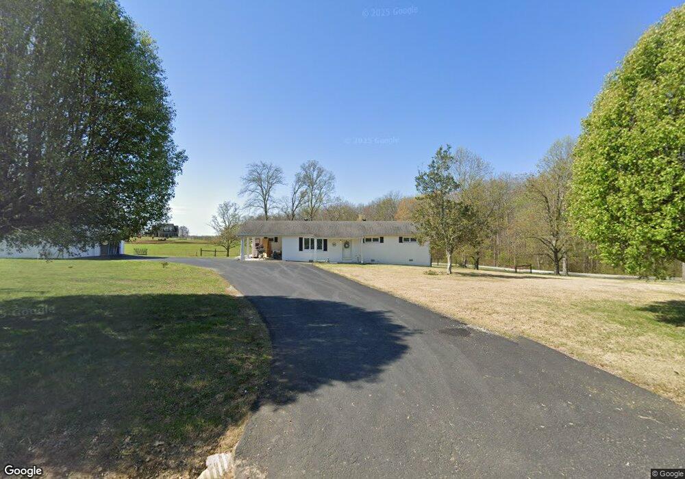
2261 Mcafee Rd Morrison, TN 37357
Estimated Value: $198,000 - $352,000
Studio
2
Baths
1,479
Sq Ft
$161/Sq Ft
Est. Value
About This Home
This home is located at 2261 Mcafee Rd, Morrison, TN 37357 and is currently estimated at $238,633, approximately $161 per square foot. 2261 Mcafee Rd is a home located in Coffee County with nearby schools including Deerfield Elementary School, Coffee County Middle School, and Coffee County Central High School.
Ownership History
Date
Name
Owned For
Owner Type
Purchase Details
Closed on
Mar 26, 2026
Sold by
Myers Mark and Myers Samuel G
Bought by
Myers Benton and Myers Abigail Faith
Current Estimated Value
Purchase Details
Closed on
Jul 27, 2018
Sold by
Nunley Virginia H
Bought by
Myers Mark E and Myers Samuel G
Home Financials for this Owner
Home Financials are based on the most recent Mortgage that was taken out on this home.
Original Mortgage
$60,000
Interest Rate
4.6%
Mortgage Type
Purchase Money Mortgage
Purchase Details
Closed on
Jul 22, 1993
Bought by
Nunley Manuel D
Create a Home Valuation Report for This Property
The Home Valuation Report is an in-depth analysis detailing your home's value as well as a comparison with similar homes in the area
Purchase History
| Date | Buyer | Sale Price | Title Company |
|---|---|---|---|
| Myers Benton | -- | None Listed On Document | |
| Myers Mark E | $87,000 | None Available | |
| Nunley Manuel D | $10,000 | -- |
Source: Public Records
Mortgage History
| Date | Status | Borrower | Loan Amount |
|---|---|---|---|
| Previous Owner | Myers Mark E | $60,000 |
Source: Public Records
Tax History
| Year | Tax Paid | Tax Assessment Tax Assessment Total Assessment is a certain percentage of the fair market value that is determined by local assessors to be the total taxable value of land and additions on the property. | Land | Improvement |
|---|---|---|---|---|
| 2025 | $666 | $28,575 | $6,875 | $21,700 |
| 2024 | $666 | $28,575 | $6,875 | $21,700 |
| 2023 | $666 | $28,575 | $0 | $0 |
| 2022 | $666 | $28,575 | $6,875 | $21,700 |
| 2021 | $642 | $21,900 | $4,425 | $17,475 |
| 2020 | $642 | $21,900 | $4,425 | $17,475 |
| 2019 | $642 | $21,900 | $4,425 | $17,475 |
| 2018 | $642 | $21,900 | $4,425 | $17,475 |
| 2017 | $690 | $21,150 | $4,850 | $16,300 |
| 2016 | $690 | $21,150 | $4,850 | $16,300 |
| 2015 | $690 | $21,150 | $4,850 | $16,300 |
| 2014 | $690 | $21,158 | $0 | $0 |
Source: Public Records
Map
Nearby Homes
- 967 Mud Creek Rd
- 0 Goforth Rd Unit 9
- 631 W Maple St
- 511 N Main St
- 101 S Mill St
- 0 Oak St
- 320 W King St
- 110 Saddle St
- 120 Boyd St
- 431 S Fair St
- 0 Jacksboro Trail Unit 7
- 0 Jacksboro Trail Unit 10
- 0 Jacksboro Trail Unit 11
- 0 Jacksboro Trail Unit 8
- 0 Jacksboro Trail Unit 9
- 7817 Shelbyville Rd
- 667 Pete Sain Rd
- 8557 Manchester Hwy
- 233 Taylor Lake Rd
- 2357 Beacon Light Rd Unit 1
- 2192 Mcafee Rd
- 2120 Mcafee Rd
- 2532 Mcafee Rd
- 2532 Mcafee Rd
- 2563 Mcafee Rd
- 2657 Mcafee Rd
- 80 Casey Rd
- 5098 Shady Grove Rd
- 362 Casey Rd
- 5077 Shady Grove Rd
- 1658 Mcafee Rd
- 1541 Mcafee Rd
- 1546 Mcafee Rd
- 38 Rigsby Rd
- 4779 Shady Grove Rd
- 227 Rigsby Rd
- 4651 Shady Grove Rd
- 5386 Shady Grove Rd
- 4324 Shady Grove Rd
- 516 Rigsby Rd
Your Personal Tour Guide
Ask me questions while you tour the home.