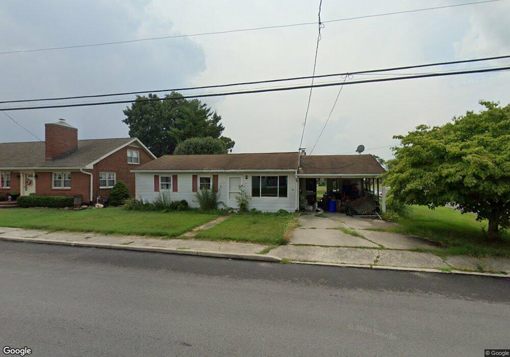
228 S 5th St Mc Sherrystown, PA 17344
Estimated Value: $202,000 - $216,775
3
Beds
1
Bath
864
Sq Ft
$241/Sq Ft
Est. Value
About This Home
This home is located at 228 S 5th St, Mc Sherrystown, PA 17344 and is currently estimated at $208,444, approximately $241 per square foot. 228 S 5th St is a home located in Adams County with nearby schools including New Oxford Senior High School, St. Teresa of Calcutta Catholic School - McSherrystown Campus, and St. Teresa of Calcutta Catholic School - Conewago Campus.
Ownership History
Date
Name
Owned For
Owner Type
Purchase Details
Closed on
May 11, 2005
Sold by
Heintzelman Clint F and Heintzelman Christine I
Bought by
Welch Thomas C and Welch Angelina R
Current Estimated Value
Home Financials for this Owner
Home Financials are based on the most recent Mortgage that was taken out on this home.
Original Mortgage
$129,900
Outstanding Balance
$68,642
Interest Rate
6.05%
Mortgage Type
New Conventional
Estimated Equity
$139,802
Create a Home Valuation Report for This Property
The Home Valuation Report is an in-depth analysis detailing your home's value as well as a comparison with similar homes in the area
Home Values in the Area
Average Home Value in this Area
Purchase History
| Date | Buyer | Sale Price | Title Company |
|---|---|---|---|
| Welch Thomas C | $129,900 | -- |
Source: Public Records
Mortgage History
| Date | Status | Borrower | Loan Amount |
|---|---|---|---|
| Open | Welch Thomas C | $129,900 |
Source: Public Records
Tax History Compared to Growth
Tax History
| Year | Tax Paid | Tax Assessment Tax Assessment Total Assessment is a certain percentage of the fair market value that is determined by local assessors to be the total taxable value of land and additions on the property. | Land | Improvement |
|---|---|---|---|---|
| 2025 | $3,490 | $133,900 | $28,600 | $105,300 |
| 2024 | $3,245 | $133,900 | $28,600 | $105,300 |
| 2023 | $3,088 | $133,900 | $28,600 | $105,300 |
| 2022 | $3,001 | $133,900 | $28,600 | $105,300 |
| 2021 | $2,863 | $133,900 | $28,600 | $105,300 |
| 2020 | $2,800 | $133,900 | $28,600 | $105,300 |
| 2019 | $2,746 | $133,900 | $28,600 | $105,300 |
| 2018 | $2,692 | $133,900 | $28,600 | $105,300 |
| 2017 | $2,588 | $133,900 | $28,600 | $105,300 |
| 2016 | -- | $133,900 | $28,600 | $105,300 |
| 2015 | -- | $133,900 | $28,600 | $105,300 |
| 2014 | -- | $133,900 | $28,600 | $105,300 |
Source: Public Records
Map
Nearby Homes
- 535 South St
- 617 N Blettner Ave Unit 120
- 417 Main St
- 337 2 Main
- 10 Bear Cir Unit 29
- 618 North St
- 335 North St
- 718 Linden Ave
- 303 Puma Dr Unit 22
- 303 Ridge Ave
- 129 Main St
- 213 S Madison St
- 1012 W Elm Ave
- 253 Vincent Dr Unit 87
- 85 South St
- 254 Princess St
- 46 Flint Dr
- 54 Flint Dr
- 65 Flint Dr
- 62 Flint Dr
- 230 S 5th St
- 218 S 5th St
- 220 S 5th St
- 216 S 5th St
- 4 Panther Dr Unit 172
- 227 S 5th St
- 223 S 5th St
- 231 S 5th St
- 10 Panther Dr Unit 171
- 421 Hillside Dr
- 219 S 5th St
- 214 S 5th St
- 217 S 5th St
- 18 Panther Dr Unit 170
- 224 Center St
- 220 Center St
- 411 Turkey Rd Unit 2
- 218 Center St
- 24 Panther Dr Unit 169
- 409 Turkey Rd