Estimated Value: $406,466 - $513,000
2
Beds
1
Bath
2,367
Sq Ft
$191/Sq Ft
Est. Value
About This Home
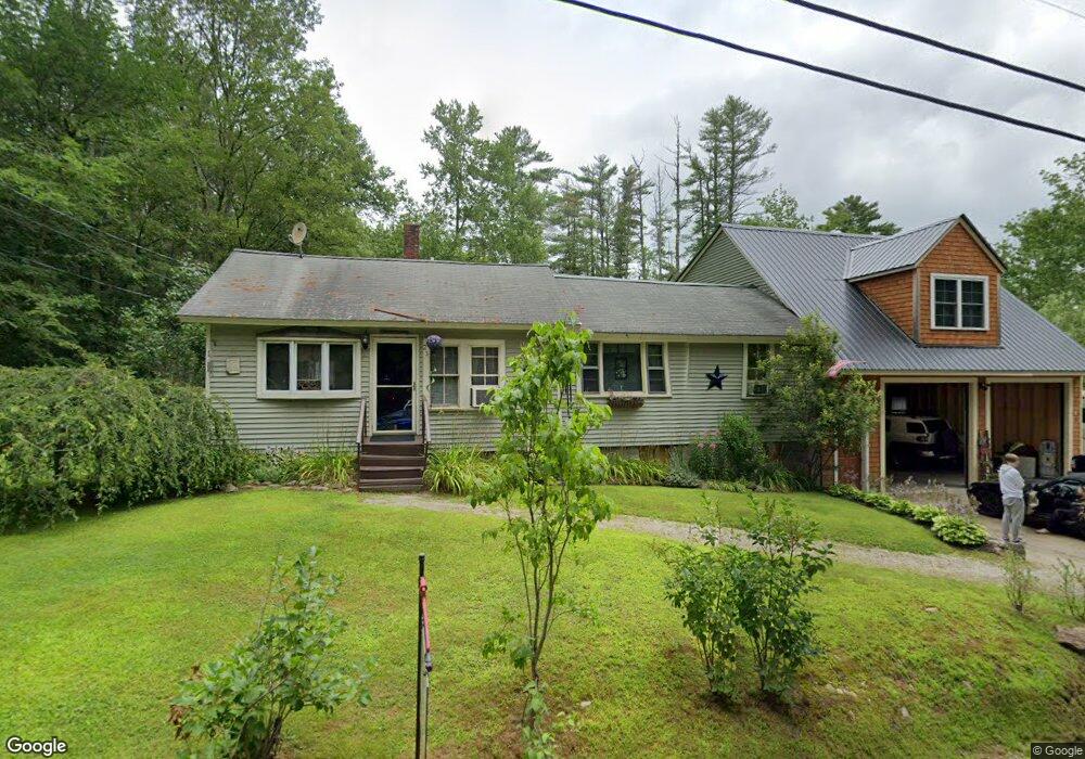
This home is located at 23 Swamp Rd, Epsom, NH 03234 and is currently estimated at $452,867, approximately $191 per square foot. 23 Swamp Rd is a home located in Merrimack County with nearby schools including Epsom Central School, Epsom Better Buddies, and Cornerstone Christian Academy.
Ownership History
Date
Name
Owned For
Owner Type
Purchase Details
Closed on
May 5, 2006
Sold by
Cosseboom Charles J and Cosseboom Tammy L
Bought by
Calnan Justin W and Calnan Christine L
Current Estimated Value
Home Financials for this Owner
Home Financials are based on the most recent Mortgage that was taken out on this home.
Original Mortgage
$190,800
Interest Rate
6.34%
Purchase Details
Closed on
Feb 8, 1999
Sold by
Hall Sheldon P and Hall Mona L
Bought by
Cosseboom Charles C and Cosseboom Tammy L
Home Financials for this Owner
Home Financials are based on the most recent Mortgage that was taken out on this home.
Original Mortgage
$40,500
Interest Rate
6.74%
Create a Home Valuation Report for This Property
The Home Valuation Report is an in-depth analysis detailing your home's value as well as a comparison with similar homes in the area
Home Values in the Area
Average Home Value in this Area
Purchase History
| Date | Buyer | Sale Price | Title Company |
|---|---|---|---|
| Calnan Justin W | $190,800 | -- | |
| Calnan Justin W | $190,800 | -- | |
| Cosseboom Charles C | $45,000 | -- |
Source: Public Records
Mortgage History
| Date | Status | Borrower | Loan Amount |
|---|---|---|---|
| Open | Cosseboom Charles C | $154,350 | |
| Closed | Calnan Justin W | $190,800 | |
| Previous Owner | Cosseboom Charles C | $40,500 |
Source: Public Records
Tax History
| Year | Tax Paid | Tax Assessment Tax Assessment Total Assessment is a certain percentage of the fair market value that is determined by local assessors to be the total taxable value of land and additions on the property. | Land | Improvement |
|---|---|---|---|---|
| 2025 | $8,216 | $468,400 | $179,500 | $288,900 |
| 2024 | $6,735 | $252,800 | $97,200 | $155,600 |
| 2023 | $6,226 | $252,800 | $97,200 | $155,600 |
| 2022 | $5,240 | $219,800 | $97,200 | $122,600 |
| 2021 | $5,196 | $219,800 | $97,200 | $122,600 |
| 2020 | $4,318 | $197,800 | $97,200 | $100,600 |
| 2019 | $4,408 | $162,700 | $81,300 | $81,400 |
| 2018 | $4,225 | $162,700 | $81,300 | $81,400 |
| 2017 | $4,177 | $162,700 | $81,300 | $81,400 |
| 2016 | $4,072 | $162,700 | $81,300 | $81,400 |
| 2015 | $3,876 | $162,700 | $81,300 | $81,400 |
| 2014 | $3,444 | $154,700 | $69,600 | $85,100 |
| 2013 | $3,467 | $153,600 | $69,600 | $84,000 |
Source: Public Records
Map
Nearby Homes
- 15 Nash Ln
- 357 New Rye Rd
- 9 Princess Ln
- 6 Lincoln St
- 2 Archer Cir
- 0 Poor Town Rd Unit 4
- 7 Pinecrest Cir
- 88 Old Town Road Extension
- 8 Bush Ave
- 0 Dover Unit 33 & 35
- 5 Old Turnpike Rd
- 1 Jefferson Ave
- 5 Catamount Hill Dr
- 157 Old Turnpike Rd
- 43 Cross Rd
- 821 Cross Country Rd
- 19 Meadow Lark Ln
- 426 Dawn Ct Unit 22
- 431 Dawn Ct Unit 17
- 427 Grady Ln Unit 29
Your Personal Tour Guide
Ask me questions while you tour the home.