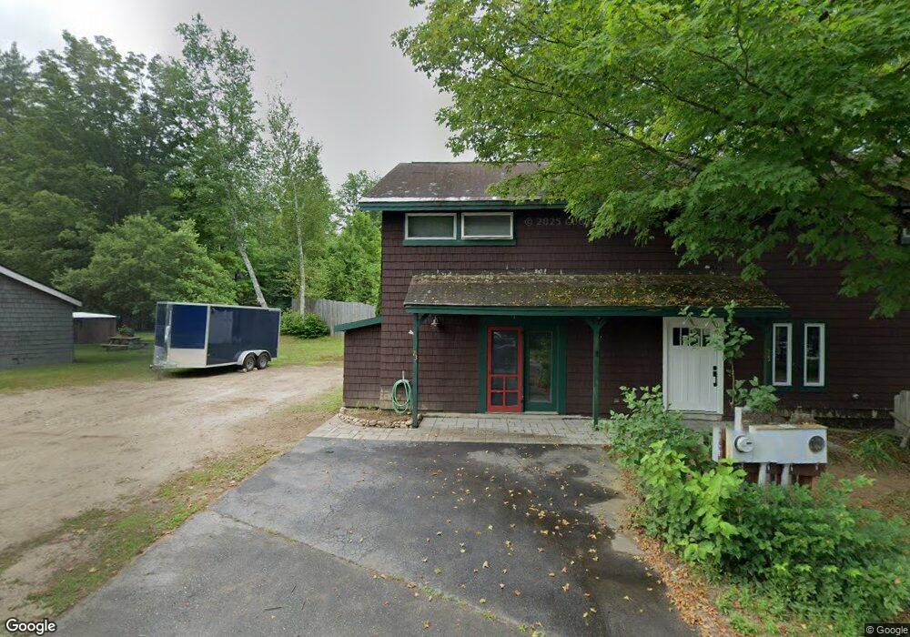
23 Young St North Woodstock, NH 03262
Estimated Value: $478,080 - $826,000
4
Beds
3
Baths
2,760
Sq Ft
$225/Sq Ft
Est. Value
About This Home
This home is located at 23 Young St, North Woodstock, NH 03262 and is currently estimated at $621,020, approximately $225 per square foot. 23 Young St is a home located in Grafton County with nearby schools including Lin-Wood Public Elementary School.
Ownership History
Date
Name
Owned For
Owner Type
Purchase Details
Closed on
Aug 16, 2002
Sold by
Linz Lester and Linz Kathryn
Bought by
Frawley Robert
Current Estimated Value
Home Financials for this Owner
Home Financials are based on the most recent Mortgage that was taken out on this home.
Original Mortgage
$132,750
Interest Rate
6.61%
Purchase Details
Closed on
Oct 1, 1999
Sold by
Greenwood Leighton C and Greenwood Joy
Bought by
Linz Lester M and Linz Kathryn
Create a Home Valuation Report for This Property
The Home Valuation Report is an in-depth analysis detailing your home's value as well as a comparison with similar homes in the area
Home Values in the Area
Average Home Value in this Area
Purchase History
| Date | Buyer | Sale Price | Title Company |
|---|---|---|---|
| Frawley Robert | $147,500 | -- | |
| Linz Lester M | $108,000 | -- |
Source: Public Records
Mortgage History
| Date | Status | Borrower | Loan Amount |
|---|---|---|---|
| Open | Linz Lester M | $189,087 | |
| Closed | Linz Lester M | $200,000 | |
| Closed | Linz Lester M | $132,750 |
Source: Public Records
Tax History Compared to Growth
Tax History
| Year | Tax Paid | Tax Assessment Tax Assessment Total Assessment is a certain percentage of the fair market value that is determined by local assessors to be the total taxable value of land and additions on the property. | Land | Improvement |
|---|---|---|---|---|
| 2024 | $4,337 | $213,450 | $67,200 | $146,250 |
| 2023 | $4,149 | $213,450 | $67,200 | $146,250 |
| 2022 | $3,923 | $213,450 | $67,200 | $146,250 |
| 2021 | $4,056 | $213,450 | $67,200 | $146,250 |
| 2020 | $4,258 | $213,450 | $67,200 | $146,250 |
| 2019 | $3,947 | $181,960 | $61,200 | $120,760 |
| 2018 | $3,954 | $181,960 | $61,200 | $120,760 |
| 2016 | $3,618 | $181,920 | $61,200 | $120,720 |
| 2015 | $3,444 | $181,920 | $61,200 | $120,720 |
| 2014 | $3,461 | $183,230 | $59,700 | $123,530 |
| 2012 | $3,360 | $187,930 | $58,670 | $129,260 |
Source: Public Records
Map
Nearby Homes
- 23 Oakes St
- 17 Ridge Dr Unit A-14
- 11 Cascade Dr Unit 288
- 206-011 Lost River Rd
- 164 Deer Park Dr Unit 160D
- 164 Deer Park Dr Unit 161D
- 164 Deer Park Dr Unit 168D
- 156 Deer Park Dr Unit 135 A
- 56 Kancamagus Hwy
- 14 Monroe Dr Unit 92
- 65 Riverfront Dr Unit 217
- 6 Monroe Dr Unit 111
- 45 Riverfront Dr Unit 242
- 16 Riverfront Dr Unit 293
- 16 Riverfront Dr Unit 292
- 25 Main St
- 252-254 Lost River Rd
- 9 Moose Ln
- 34 Franklin St
- 5 Robin Rd Unit 1