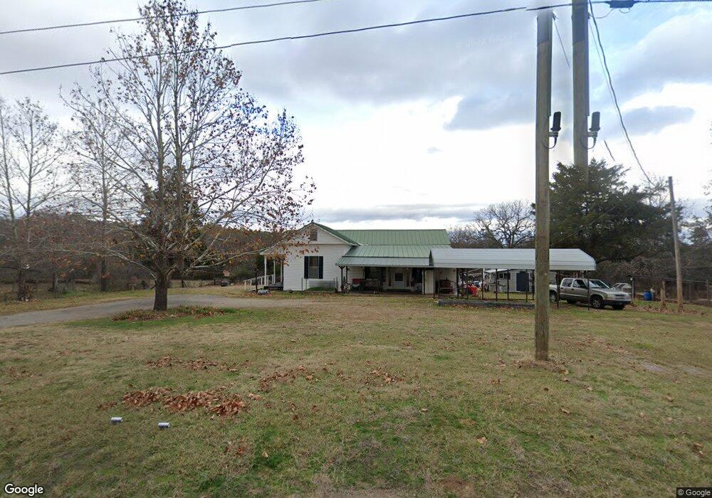
23327 Highway 45 Hackett, AR 72937
Estimated Value: $194,463 - $285,000
Studio
2
Baths
2,022
Sq Ft
$124/Sq Ft
Est. Value
About This Home
This home is located at 23327 Highway 45, Hackett, AR 72937 and is currently estimated at $251,154, approximately $124 per square foot. 23327 Highway 45 is a home located in Sebastian County with nearby schools including Hackett Elementary School and Hackett High School.
Ownership History
Date
Name
Owned For
Owner Type
Purchase Details
Closed on
Oct 11, 2023
Sold by
Carter W A W and Carter Nancy
Bought by
Carter Matthew Melton Alan
Current Estimated Value
Purchase Details
Closed on
Feb 25, 2000
Bought by
Carter
Purchase Details
Closed on
Dec 27, 1978
Bought by
Carter
Create a Home Valuation Report for This Property
The Home Valuation Report is an in-depth analysis detailing your home's value as well as a comparison with similar homes in the area
Purchase History
| Date | Buyer | Sale Price | Title Company |
|---|---|---|---|
| Carter Matthew Melton Alan | -- | None Listed On Document | |
| Carter Melton E | -- | None Listed On Document | |
| Carter William Cleveland | -- | None Listed On Document | |
| Carter | -- | -- | |
| Carter | $3,000 | -- |
Source: Public Records
Mortgage History
| Date | Status | Borrower | Loan Amount |
|---|---|---|---|
| Closed | Carter Matthew Melton Alan | $0 |
Source: Public Records
Tax History
| Year | Tax Paid | Tax Assessment Tax Assessment Total Assessment is a certain percentage of the fair market value that is determined by local assessors to be the total taxable value of land and additions on the property. | Land | Improvement |
|---|---|---|---|---|
| 2025 | $422 | $31,037 | $5,603 | $25,434 |
| 2024 | $421 | $19,696 | $4,372 | $15,324 |
| 2023 | $17 | $20,130 | $4,890 | $15,240 |
| 2022 | $66 | $20,130 | $4,890 | $15,240 |
| 2021 | $66 | $20,130 | $4,890 | $15,240 |
| 2020 | $66 | $20,130 | $4,890 | $15,240 |
| 2019 | $46 | $16,110 | $4,820 | $11,290 |
| 2018 | $71 | $16,110 | $4,820 | $11,290 |
| 2017 | $71 | $16,110 | $4,820 | $11,290 |
| 2016 | $421 | $16,110 | $4,820 | $11,290 |
| 2015 | $421 | $16,110 | $4,820 | $11,290 |
| 2014 | $71 | $8,975 | $4,710 | $4,265 |
Source: Public Records
Map
Nearby Homes
- 8596 Ar-252
- 5015 Slaytonville Rd
- 5524 Slaytonville Rd
- 8800 Shady Valley Ln
- 8911 W Highway 252
- 4721 Cobblestone Rd
- 5525 Slaytonville Rd
- lot 5 Cobblestone Rd
- 8443 S Highway 253
- 10011 Southshore Dr
- 412 N 3rd St
- 8720 Horseshoe Loop
- 503 Black Creek Ln
- 202 Hooper St
- 6404 W Highway 10
- 610 N Oak St
- 3000 Mockingbird Hill Rd
- 11238 Liberty Hill Rd
- 9614 Woolly Bend
- 900 W Hackett Rd
- 5728 Briarwood Crescent
- 23351 Highway 45
- 23351 Highway 45
- 5618 Briarwood Crescent
- 23401 Highway 45
- 23210 Highway 45
- 23210 Highway 45
- 5901 Briarwood Crescent
- 23431 Highway 45
- 0 Bear Creek Dr Unit 1023961
- 23509 Highway 45
- 23602 Highway 45
- 7300 Hill Top Heights
- 23611 Highway 45
- 7814 Hill Top Terrace
- 7515 Hill Top Terrace
- 7616 Hill Top Terrace
- 7800 Hill Top Terrace
- TBD W Highway 252
- Lot 300-302
Your Personal Tour Guide
Ask me questions while you tour the home.