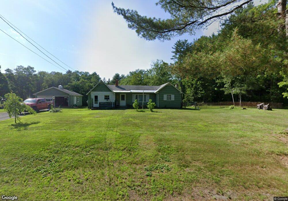
239 W Gill Rd Gill, MA 01354
Gill NeighborhoodEstimated Value: $154,000 - $299,000
2
Beds
1
Bath
1,220
Sq Ft
$184/Sq Ft
Est. Value
About This Home
This home is located at 239 W Gill Rd, Gill, MA 01354 and is currently estimated at $224,700, approximately $184 per square foot. 239 W Gill Rd is a home located in Franklin County with nearby schools including Full Circle School.
Ownership History
Date
Name
Owned For
Owner Type
Purchase Details
Closed on
Jun 24, 2025
Sold by
Johnson Travis and Johnson Charlotte
Bought by
Johnson Travis
Current Estimated Value
Purchase Details
Closed on
Feb 5, 2021
Sold by
Johnson Travis
Bought by
Johnson Travis and Johnson Charlotte
Home Financials for this Owner
Home Financials are based on the most recent Mortgage that was taken out on this home.
Original Mortgage
$25,000
Interest Rate
2.65%
Mortgage Type
New Conventional
Purchase Details
Closed on
Nov 8, 2019
Sold by
Kendrow Carolyn H Est
Bought by
Johnson Travis
Home Financials for this Owner
Home Financials are based on the most recent Mortgage that was taken out on this home.
Original Mortgage
$84,800
Interest Rate
3.6%
Mortgage Type
New Conventional
Purchase Details
Closed on
Sep 4, 2014
Sold by
Grella Marian D
Bought by
Kendrow Carolyn H
Create a Home Valuation Report for This Property
The Home Valuation Report is an in-depth analysis detailing your home's value as well as a comparison with similar homes in the area
Home Values in the Area
Average Home Value in this Area
Purchase History
| Date | Buyer | Sale Price | Title Company |
|---|---|---|---|
| Johnson Travis | -- | -- | |
| Johnson Travis | -- | -- | |
| Johnson Travis | -- | None Available | |
| Johnson Travis | -- | None Available | |
| Johnson Travis | $63,200 | -- | |
| Johnson Travis | $31,600 | -- | |
| Kendrow Carolyn H | -- | -- | |
| Kendrow Carolyn H | -- | -- | |
| Kendrow Carolyn H | -- | -- |
Source: Public Records
Mortgage History
| Date | Status | Borrower | Loan Amount |
|---|---|---|---|
| Previous Owner | Johnson Travis | $25,000 | |
| Previous Owner | Johnson Travis | $84,800 |
Source: Public Records
Tax History Compared to Growth
Tax History
| Year | Tax Paid | Tax Assessment Tax Assessment Total Assessment is a certain percentage of the fair market value that is determined by local assessors to be the total taxable value of land and additions on the property. | Land | Improvement |
|---|---|---|---|---|
| 2025 | $2,265 | $154,500 | $92,800 | $61,700 |
| 2024 | $2,226 | $143,800 | $88,000 | $55,800 |
| 2023 | $2,114 | $130,700 | $80,000 | $50,700 |
| 2022 | $2,114 | $126,900 | $76,200 | $50,700 |
| 2021 | $2,227 | $128,800 | $76,200 | $52,600 |
| 2020 | $2,118 | $122,800 | $72,600 | $50,200 |
| 2019 | $2,832 | $164,100 | $69,100 | $95,000 |
| 2018 | $2,745 | $159,800 | $69,100 | $90,700 |
| 2017 | $2,649 | $159,800 | $69,100 | $90,700 |
| 2016 | $2,694 | $159,900 | $74,100 | $85,800 |
| 2015 | $2,659 | $157,800 | $74,100 | $83,700 |
Source: Public Records
Map
Nearby Homes
- 182 Main Rd
- 47 Cross St
- 59 River St
- 23 Industrial Dr
- 1 Northfield Rd
- 001 Adams Rd
- 75 South St Unit 3
- 31 Lovers Ln
- 180 Bald Mountain Rd
- 0 Meadow View Ln & Pine Meadow
- 30 Park St
- 83 Eden Trail Branch
- 21 Hillside Ave
- 696 Bernardston Rd
- 72 Meadowood Dr
- 0 Millers Falls Rd Unit 73034825
- 539 Fox Hill Rd
- 34 Brookside Ave
- 45 Millers Falls Rd
- 79 Burnham Rd