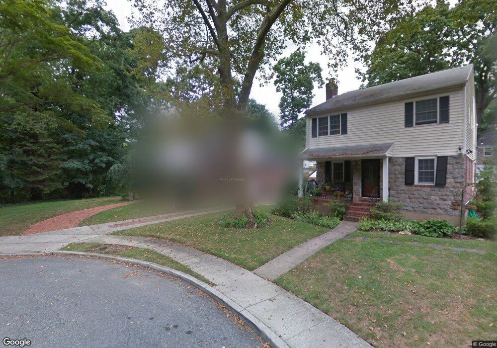
24 Mayfair Ct Freeport, NY 11520
Estimated Value: $652,000 - $669,261
3
Beds
2
Baths
1,344
Sq Ft
$492/Sq Ft
Est. Value
About This Home
This home is located at 24 Mayfair Ct, Freeport, NY 11520 and is currently estimated at $660,631, approximately $491 per square foot. 24 Mayfair Ct is a home located in Nassau County with nearby schools including Caroline G. Atkinson Intermediate School, Columbus Avenue School, and John W Dodd Middle School.
Ownership History
Date
Name
Owned For
Owner Type
Purchase Details
Closed on
Oct 31, 2014
Sold by
Hinnant Linda
Bought by
Corke Stacey R and Corke Winston B
Current Estimated Value
Home Financials for this Owner
Home Financials are based on the most recent Mortgage that was taken out on this home.
Original Mortgage
$325,600
Outstanding Balance
$251,700
Interest Rate
4.25%
Mortgage Type
FHA
Estimated Equity
$408,931
Purchase Details
Closed on
Sep 1, 2005
Sold by
Strauss Marc
Bought by
Hinnant Linda
Purchase Details
Closed on
Nov 23, 1998
Sold by
Mooney Donald and Mooney Patricia
Bought by
Strauss Marc and Strauss-Williams Sandra
Create a Home Valuation Report for This Property
The Home Valuation Report is an in-depth analysis detailing your home's value as well as a comparison with similar homes in the area
Home Values in the Area
Average Home Value in this Area
Purchase History
| Date | Buyer | Sale Price | Title Company |
|---|---|---|---|
| Corke Stacey R | $340,000 | Old Republic Title | |
| Hinnant Linda | $407,500 | -- | |
| Strauss Marc | $180,000 | -- |
Source: Public Records
Mortgage History
| Date | Status | Borrower | Loan Amount |
|---|---|---|---|
| Open | Corke Stacey R | $325,600 |
Source: Public Records
Tax History
| Year | Tax Paid | Tax Assessment Tax Assessment Total Assessment is a certain percentage of the fair market value that is determined by local assessors to be the total taxable value of land and additions on the property. | Land | Improvement |
|---|---|---|---|---|
| 2025 | $9,250 | $429 | $170 | $259 |
| 2024 | $952 | $429 | $170 | $259 |
Source: Public Records
Map
Nearby Homes
- 2098 Felix Ct
- 883 Mckenna Ave
- 15 Mckenna Ave
- 6 Beverly Pkwy
- 215 N Brookside Ave
- 858 Seaman Ave E
- 89 Delaware Ave
- 2 Florence St
- 1850 Voshage St
- 1878 Lake Dr W
- 107 California Ave
- 1 Willowbrook Ln
- 757 Bixby Dr
- 661 Saint Lukes Place
- 60 Connecticut Ave
- 619 Ashland Ave
- 139 New York Ave
- 156 Juanita Ave
- 161 Wallace St
- 101 Wallace St
- 20 Mayfair Ct
- 23 Mayflower Ct
- 16 Mayfair Ct
- 15 Mayflower Ct
- 10 Mayfair Ct
- 11 Mayfair Ct
- 11 Mayfair Ct
- 9 Mayflower Ct
- 107 N Brookside Ave
- 3 Mayfair Ct
- 3 Mayfair Ct
- 26 Mayflower Ct
- 117 N Brookside Ave
- 12 Felix Ct
- 16 Mayflower Ct
- 2069 Windsor Rd
- 3 Windsor Rd
- 10 Mayflower Ct
- 2049 Windsor Rd
- 2083 Felix Ct
Your Personal Tour Guide
Ask me questions while you tour the home.