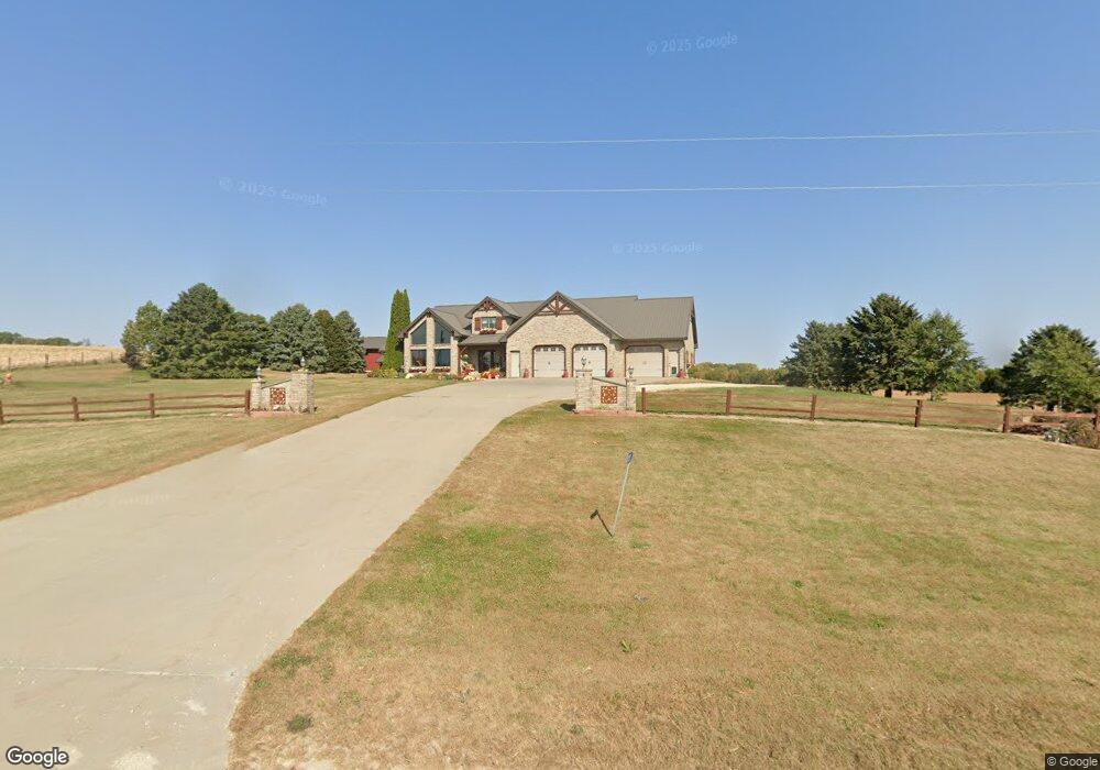
24251 Garryowen Rd Cascade, IA 52033
Estimated Value: $501,000 - $697,000
--
Bed
6
Baths
2,703
Sq Ft
$219/Sq Ft
Est. Value
About This Home
This home is located at 24251 Garryowen Rd, Cascade, IA 52033 and is currently estimated at $592,839, approximately $219 per square foot. 24251 Garryowen Rd is a home with nearby schools including Cascade Elementary School, Cascade Junior/Senior High School, and Aquin Catholic Elementary School.
Ownership History
Date
Name
Owned For
Owner Type
Purchase Details
Closed on
Mar 11, 2014
Sold by
Sand Valley Gilts Inc
Bought by
Boyle Scott M and Boyle Elizabeth A
Current Estimated Value
Purchase Details
Closed on
Sep 7, 2013
Sold by
Menster Michael G
Bought by
Boyle Scott M and Boyle Elizabeth A
Home Financials for this Owner
Home Financials are based on the most recent Mortgage that was taken out on this home.
Original Mortgage
$45,000
Interest Rate
4.39%
Mortgage Type
New Conventional
Create a Home Valuation Report for This Property
The Home Valuation Report is an in-depth analysis detailing your home's value as well as a comparison with similar homes in the area
Home Values in the Area
Average Home Value in this Area
Purchase History
| Date | Buyer | Sale Price | Title Company |
|---|---|---|---|
| Boyle Scott M | -- | None Available | |
| Boyle Scott M | $300,000 | None Available |
Source: Public Records
Mortgage History
| Date | Status | Borrower | Loan Amount |
|---|---|---|---|
| Previous Owner | Boyle Scott M | $45,000 |
Source: Public Records
Tax History Compared to Growth
Tax History
| Year | Tax Paid | Tax Assessment Tax Assessment Total Assessment is a certain percentage of the fair market value that is determined by local assessors to be the total taxable value of land and additions on the property. | Land | Improvement |
|---|---|---|---|---|
| 2025 | $5,702 | $640,500 | $146,900 | $493,600 |
| 2024 | $5,702 | $551,500 | $139,900 | $411,600 |
| 2023 | $5,448 | $549,800 | $139,900 | $409,900 |
| 2022 | $4,516 | $385,300 | $107,650 | $277,650 |
| 2021 | $4,516 | $385,300 | $107,650 | $277,650 |
| 2020 | $4,582 | $373,590 | $94,200 | $279,390 |
| 2019 | $4,570 | $373,590 | $94,200 | $279,390 |
| 2018 | $4,484 | $354,470 | $81,500 | $272,970 |
| 2017 | $4,390 | $354,470 | $81,500 | $272,970 |
| 2016 | $4,350 | $334,120 | $72,300 | $261,820 |
| 2015 | $4,350 | $334,120 | $72,300 | $261,820 |
| 2014 | $4,248 | $314,960 | $66,400 | $248,560 |
Source: Public Records
Map
Nearby Homes
- 24765 151st Route
- 105 Harrison St SE
- 313 1st Ave E
- 601 7th Ave SW
- 609 7th Ave SW
- 814 5th Ave SW
- 815 4th Ave SW
- 816 6th Ave NW
- 1115 NW Clare Ct
- 1013 Clare Ct NW Unit Northwest
- 1442 Iowa 136
- 9162 Richland Rd
- 278 Bernard Rd
- TBD Wieferich Rd
- 9600 Ash St
- 800 Bobcat Ave Unit SE
- 203 3rd Ave SW
- 0 W 1st Ave
- 3000 150th St
- 22710 Lake Shore Dr