


243 Degroff Ln Rabun Gap, GA 30568
Estimated payment $2,676/month
Highlights
- Craftsman Architecture
- Deck
- Family Room with Fireplace
- Mountain View
- Private Lot
- Wooded Lot
About This Home
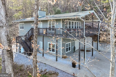
Private Mountain Retreat in Desirable Wolffork Valley! Escape to peace, privacy, and picture-perfect views in the heart of beautiful Wolffork Valley. This hidden gem sits on 1.1 acres bordering US Forestry land-offering rare seclusion just 10 minutes from the charming town of Clayton. A brand-new concrete driveway welcomes you to this delightful surprise perched on a gentle rise, featuring Hardie plank siding, quality trim, and a metal roof built for low-maintenance living. Inside, you'll find the open-concept great room is warm and welcoming with vaulted ceilings, wide plank ceramic tile floors, a cozy gas fireplace, and abundant natural light. The state-of-the-art kitchen boasts custom cabinetry, stainless steel appliances, a walk-in pantry, gorgeous granite countertops, and a large island with a breakfast bar-perfect for casual meals or entertaining. The main level includes kitchen, living, dining, and two spacious bedrooms and a lovely bathroom with a double vanity completes the main level. Downstairs, the walk-out lower level expands your living space with a large family room anchored by a charming pellet stove that can heat the entire home. A third bedroom, full bath, and convenient laundry area complete this level. The drive-under garage and carport are more than practical-they double as a fantastic workshop or "man cave," fully equipped with built-in storage, shelving, and room for all your projects. And then there's the showpiece: a massive, vaulted-ceiling porch where you'll spend endless hours surrounded by nature, watching wildlife, and taking in the stunning seasonal views of the valley and surrounding mountains. Located just minutes from farm-to-table restaurants, art galleries, boutiques, and antique shops in downtown Clayton-and surrounded by outdoor adventures like hiking, fishing, horseback riding, and three nearby state parks-this home has it all.
Listing Agent
Rabun Realty Brokerage Phone: 770-480-5161 License #85751 Listed on: 06/05/2025
Home Details
Home Type
- Single Family
Est. Annual Taxes
- $2,541
Year Built
- Built in 2011 | Remodeled
Lot Details
- 1.1 Acre Lot
- Private Lot
- Sloped Lot
- Wooded Lot
Property Views
- Mountain
- Seasonal
Home Design
- Craftsman Architecture
- Bungalow
- Metal Roof
- Concrete Siding
Interior Spaces
- 2,184 Sq Ft Home
- 2-Story Property
- Vaulted Ceiling
- Ceiling Fan
- Double Pane Windows
- Family Room with Fireplace
- 2 Fireplaces
- Living Room with Fireplace
- Combination Dining and Living Room
- Bonus Room
Kitchen
- Convection Oven
- Microwave
- Ice Maker
- Dishwasher
- Stainless Steel Appliances
- Kitchen Island
- Solid Surface Countertops
- Disposal
Flooring
- Carpet
- Tile
Bedrooms and Bathrooms
- 3 Bedrooms | 2 Main Level Bedrooms
- Primary Bedroom on Main
- Walk-In Closet
- Double Vanity
- Bathtub Includes Tile Surround
- Separate Shower
Laundry
- Dryer
- Washer
Finished Basement
- Basement Fills Entire Space Under The House
- Interior and Exterior Basement Entry
- Finished Basement Bathroom
- Laundry in Basement
- Natural lighting in basement
Parking
- 4 Car Garage
- Garage Door Opener
- Drive Under Main Level
Outdoor Features
- Deck
Schools
- Rabun County Primary/Elementar Elementary School
- Rabun County Middle School
- Rabun County High School
Utilities
- Central Heating and Cooling System
- Heat Pump System
- Septic Tank
- High Speed Internet
- Phone Available
Community Details
- No Home Owners Association
Listing and Financial Details
- Tax Lot 121
Map
Home Values in the Area
Average Home Value in this Area
Tax History
| Year | Tax Paid | Tax Assessment Tax Assessment Total Assessment is a certain percentage of the fair market value that is determined by local assessors to be the total taxable value of land and additions on the property. | Land | Improvement |
|---|---|---|---|---|
| 2025 | $2,823 | $175,887 | $11,669 | $164,218 |
| 2024 | $2,676 | $166,713 | $11,669 | $155,044 |
| 2023 | $2,637 | $144,101 | $10,982 | $133,119 |
| 2022 | $2,545 | $139,064 | $10,296 | $128,768 |
| 2021 | $952 | $50,752 | $7,762 | $42,990 |
| 2020 | $928 | $47,868 | $7,762 | $40,106 |
| 2019 | $935 | $47,868 | $7,762 | $40,106 |
| 2018 | $1,004 | $51,194 | $11,088 | $40,106 |
| 2017 | $962 | $51,194 | $11,088 | $40,106 |
| 2016 | $849 | $45,043 | $11,088 | $33,955 |
| 2015 | $820 | $42,575 | $11,088 | $31,487 |
| 2014 | $824 | $42,575 | $11,088 | $31,487 |
Property History
| Date | Event | Price | List to Sale | Price per Sq Ft |
|---|---|---|---|---|
| 09/05/2025 09/05/25 | Price Changed | $469,000 | -2.1% | $215 / Sq Ft |
| 06/05/2025 06/05/25 | For Sale | $479,000 | -- | $219 / Sq Ft |
Purchase History
| Date | Type | Sale Price | Title Company |
|---|---|---|---|
| Warranty Deed | $365,000 | -- | |
| Warranty Deed | $365,000 | -- | |
| Warranty Deed | $125,000 | -- | |
| Warranty Deed | $125,000 | -- | |
| Deed | $34,000 | -- | |
| Deed | $34,000 | -- |
Mortgage History
| Date | Status | Loan Amount | Loan Type |
|---|---|---|---|
| Open | $265,000 | New Conventional | |
| Closed | $265,000 | New Conventional |
Source: Georgia MLS
MLS Number: 10537252
APN: 040A-051C
Disclaimer: Certain information contained herein is derived from information provided by parties other than Homes.com. All information provided is deemed reliable, but is not guaranteed to be accurate and should be independently verified.
![]() The data relating to real estate for sale on this web site comes in part from the Broker Reciprocity Program of Georgia MLS. Real estate listings held by brokerage firms other than Redfin are marked with the Broker Reciprocity logo and detailed information about them includes the name of the listing brokers. Information deemed reliable but not guaranteed. Copyright 2025 Georgia MLS. All rights reserved.
The data relating to real estate for sale on this web site comes in part from the Broker Reciprocity Program of Georgia MLS. Real estate listings held by brokerage firms other than Redfin are marked with the Broker Reciprocity logo and detailed information about them includes the name of the listing brokers. Information deemed reliable but not guaranteed. Copyright 2025 Georgia MLS. All rights reserved.
- 786 Hope Haven Ln
- 137 Olds Mountain Peak Rd
- 5192 Wolffork Rd
- 1422 Wolffork Rd
- 784 Wolffork Church Rd
- 153 Coleman Heights Ln
- 0 John Beck Dockins Rd Unit 10606531
- 5019 Wolffork Rd
- 52 Lucky Ln
- 0 Allen Cove Rd Unit 10586573
- 230 Majors Ln
- 0 Sylvan Lake Dr Unit 47,48 10485897
- 0 Ov Justus Rd
- 46 Clare Ln
- 0 Uplander Unit 10628218
- 0 Uplander Unit M181832
- 0 Crest Ln Unit LOT 5 10572844
- 0 Pitts Way Unit 10592369
- 0 Wolffork Rd Unit 10624471
- 373 Western Way
- 160 Marsen Knob Dr
- 21 Switchback
- 105 Wz
- 527 Mountainside Dr
- 173 Payne Hill Dr
- 74 Lockerbie Ct Unit 202
- 18 Living Waters Way
- 96 Saddle Gap Dr
- 3 Berkshire Ln Unit 3
- 21 Staghorn Point
- 103 Bent Grass Way
- 10 Addington Villas Dr
- 1359 Camp Creek Rd Unit Suite TWO
- 35 Misty Meadow Ln
- 297 Knoll Dr
- 297 Knoll Dr
- 1028 Carl Slagle Rd
- 966 Gibson Rd
- 2475 Wayah Rd
- 103C Willow View Dr
