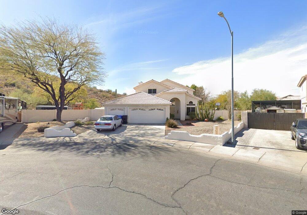
24846 N 62nd Ave Glendale, AZ 85310
Stetson Valley NeighborhoodEstimated Value: $517,308 - $618,000
4
Beds
3
Baths
2,018
Sq Ft
$283/Sq Ft
Est. Value
About This Home
This home is located at 24846 N 62nd Ave, Glendale, AZ 85310 and is currently estimated at $570,827, approximately $282 per square foot. 24846 N 62nd Ave is a home located in Maricopa County with nearby schools including Las Brisas Elementary School, Hillcrest Middle School, and Sandra Day O'connor High School.
Ownership History
Date
Name
Owned For
Owner Type
Purchase Details
Closed on
Sep 22, 1994
Sold by
First Service Title Agency Inc
Bought by
Earlie Homes & Associates Inc
Current Estimated Value
Home Financials for this Owner
Home Financials are based on the most recent Mortgage that was taken out on this home.
Original Mortgage
$570,050
Interest Rate
8.61%
Mortgage Type
Construction
Create a Home Valuation Report for This Property
The Home Valuation Report is an in-depth analysis detailing your home's value as well as a comparison with similar homes in the area
Home Values in the Area
Average Home Value in this Area
Purchase History
| Date | Buyer | Sale Price | Title Company |
|---|---|---|---|
| Earlie Homes & Associates Inc | -- | First Service Title Agency I |
Source: Public Records
Mortgage History
| Date | Status | Borrower | Loan Amount |
|---|---|---|---|
| Closed | Earlie Homes & Associates Inc | $570,050 |
Source: Public Records
Tax History Compared to Growth
Tax History
| Year | Tax Paid | Tax Assessment Tax Assessment Total Assessment is a certain percentage of the fair market value that is determined by local assessors to be the total taxable value of land and additions on the property. | Land | Improvement |
|---|---|---|---|---|
| 2025 | $2,600 | $28,747 | -- | -- |
| 2024 | $2,864 | $27,378 | -- | -- |
| 2023 | $2,864 | $41,160 | $8,230 | $32,930 |
| 2022 | $2,768 | $31,310 | $6,260 | $25,050 |
| 2021 | $2,841 | $28,100 | $5,620 | $22,480 |
| 2020 | $2,792 | $26,460 | $5,290 | $21,170 |
| 2019 | $2,712 | $25,020 | $5,000 | $20,020 |
| 2018 | $2,626 | $24,350 | $4,870 | $19,480 |
| 2017 | $2,541 | $22,770 | $4,550 | $18,220 |
| 2016 | $2,411 | $21,500 | $4,300 | $17,200 |
| 2015 | $1,827 | $21,880 | $4,370 | $17,510 |
Source: Public Records
Map
Nearby Homes
- 6312 W Villa Linda Dr
- 6410 W Buckskin Trail
- 24649 N 65th Ave
- 24630 N 65th Ave
- 6337 W Avenida Del Rey
- 6339 W Range Mule Dr
- 6515 W Avenida Del Rey
- 24213 N 65th Ave Unit 28
- 6152 W Alameda Rd Unit 11
- 6156 W Alameda Rd Unit 12
- 6131 W Alameda Rd
- 6604 W Leiber Place
- 6610 W Leiber Place
- 6763 W Bronco Trail
- 6772 W Buckskin Trail
- 25617 N 67th Dr
- 6408 W Prickly Pear Trail
- 24016 N 66th Ln
- 6336 W Paso Trail
- 6816 W Bronco Trail
- 24850 N 62nd Ave
- 24840 N 62nd Ave
- 24856 N 62nd Ave
- 6304 W Villa Linda Dr
- 6309 W Villa Linda Dr
- 24851 N 62nd Ave
- 6308 W Villa Linda Dr
- 6313 W Villa Linda Dr
- 24855 N 62nd Ave
- 24830 N 62nd Ave
- 6317 W Villa Linda Dr
- 6170 W Fallen Leaf Ln
- 24859 N 62nd Ave
- 6316 W Villa Linda Dr
- 6321 W Villa Linda Dr
- 6166 W Fallen Leaf Ln
- 6320 W Villa Linda Dr
- 6162 W Fallen Leaf Ln
- 6325 W Villa Linda Dr
- 6324 W Villa Linda Dr