Estimated Value: $259,000 - $379,000
6
Beds
4
Baths
2,027
Sq Ft
$159/Sq Ft
Est. Value
About This Home
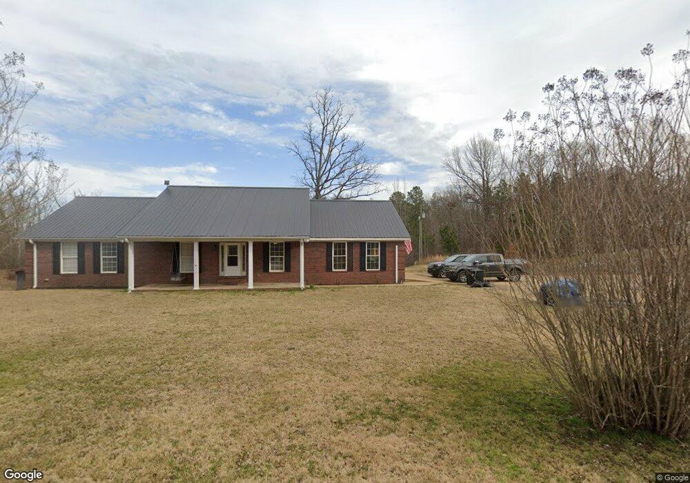
This home is located at 2507 Feddie Davis Rd Unit 446060, Ramer, TN 38367 and is currently estimated at $321,604, approximately $158 per square foot. 2507 Feddie Davis Rd Unit 446060 is a home located in McNairy County with nearby schools including Ramer Elementary School, Selmer Elementary School, and Michie Elementary School.
Ownership History
Date
Name
Owned For
Owner Type
Purchase Details
Closed on
Jan 30, 2023
Sold by
Jones Jennifer
Bought by
Flood Jeremy and Flood Brittany
Current Estimated Value
Home Financials for this Owner
Home Financials are based on the most recent Mortgage that was taken out on this home.
Original Mortgage
$358,000
Outstanding Balance
$341,184
Interest Rate
4%
Mortgage Type
VA
Estimated Equity
-$19,580
Purchase Details
Closed on
Aug 19, 2010
Sold by
Wilson Morris F
Bought by
Palomino Elizabeth
Create a Home Valuation Report for This Property
The Home Valuation Report is an in-depth analysis detailing your home's value as well as a comparison with similar homes in the area
Home Values in the Area
Average Home Value in this Area
Purchase History
| Date | Buyer | Sale Price | Title Company |
|---|---|---|---|
| Flood Jeremy | $358,000 | -- | |
| Palomino Elizabeth | $165,000 | -- |
Source: Public Records
Mortgage History
| Date | Status | Borrower | Loan Amount |
|---|---|---|---|
| Open | Flood Jeremy | $358,000 |
Source: Public Records
Tax History Compared to Growth
Tax History
| Year | Tax Paid | Tax Assessment Tax Assessment Total Assessment is a certain percentage of the fair market value that is determined by local assessors to be the total taxable value of land and additions on the property. | Land | Improvement |
|---|---|---|---|---|
| 2024 | $1,267 | $80,350 | $1,300 | $79,050 |
| 2023 | $1,220 | $80,050 | $1,000 | $79,050 |
| 2022 | $1,220 | $77,325 | $1,000 | $76,325 |
| 2021 | $1,181 | $57,700 | $1,250 | $56,450 |
| 2020 | $1,181 | $57,700 | $1,250 | $56,450 |
| 2019 | $1,164 | $56,875 | $1,250 | $55,625 |
| 2018 | $1,164 | $56,875 | $1,250 | $55,625 |
| 2017 | $1,164 | $56,875 | $1,250 | $55,625 |
| 2016 | $1,141 | $56,875 | $1,250 | $55,625 |
| 2015 | $1,189 | $56,875 | $1,250 | $55,625 |
| 2014 | $1,121 | $53,650 | $1,375 | $52,275 |
Source: Public Records
Map
Nearby Homes
- 0 William Teague Ln
- 5579 Ramer Selmer Rd
- 249 Amber Ln
- 3285 Tennessee 57
- 183 Matlock Rd
- 6052 U S 45
- 4083 Tennessee 57
- 147 Jones St
- 239 Old No 5
- 142 Treece St
- 1020 Mulberry Ave
- 160 Chewalla Rd
- 6907 U S 45
- 745 Mulberry Ave
- 0 Mulberry Ave Unit RTC3016092
- 00 Mulberry Ave
- 156 Bassham Ln
- 7437 U S 45
- 951 Tennessee 57
- 599 Lake Trail Loop
- 2507 Feddie Davis Rd
- 2583 Feddie Davis Rd
- 2496 Feddie Davis Rd
- 3443 Ramer Selmer Rd
- 2310 Feddie Davis Rd Unit 430110
- 2310 Feddie Davis Rd
- 3342 Ramer Selmer Rd
- 65 Honeysuckle Ln
- 3240 Ramer Selmer Rd
- 3240 Ramer Selmer Rd
- 3424 Ramer Selmer Rd
- 125 Honeysuckle Ln
- 163 Honeysuckle Ln
- 5206 Ramer Selmer Rd
- 3144 Ramer Selmer Rd
- 2224 Feddie Davis Rd
- 2357 Feddie Davis Rd
- 2223 Feddie Davis Rd
- 3532 Ramer Selmer Rd
- 2251 Feddie Davis Rd