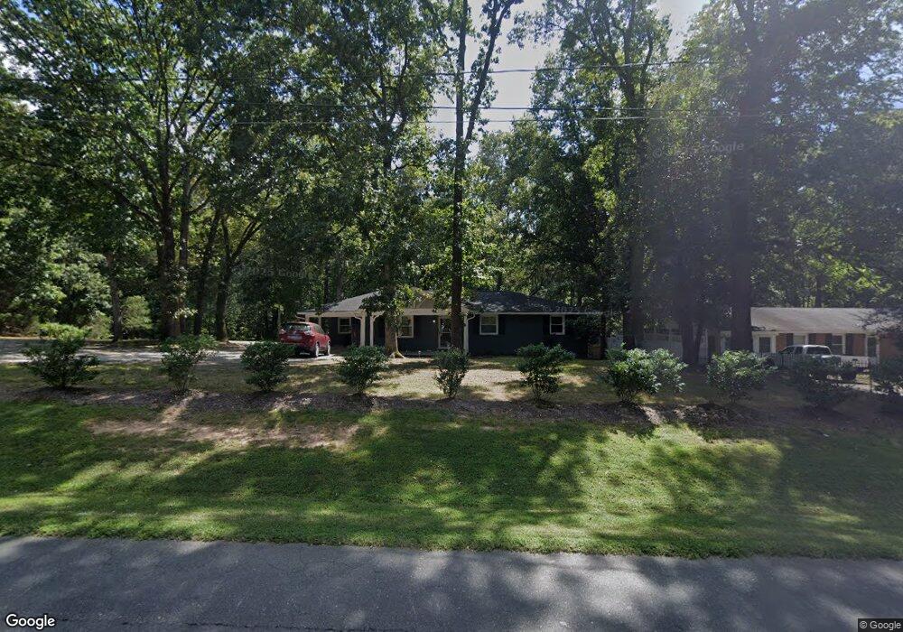
2514 Glover Rd Durham, NC 27703
Bethesda NeighborhoodEstimated Value: $294,000 - $371,000
3
Beds
2
Baths
1,520
Sq Ft
$219/Sq Ft
Est. Value
About This Home
This home is located at 2514 Glover Rd, Durham, NC 27703 and is currently estimated at $333,453, approximately $219 per square foot. 2514 Glover Rd is a home located in Durham County with nearby schools including Bethesda Elementary School, John W Neal Middle School, and Southern School of Energy & Sustainability.
Ownership History
Date
Name
Owned For
Owner Type
Purchase Details
Closed on
Jul 19, 2018
Sold by
Aderia Properties Llc
Bought by
Stubbs Olauhdo E
Current Estimated Value
Home Financials for this Owner
Home Financials are based on the most recent Mortgage that was taken out on this home.
Original Mortgage
$206,196
Outstanding Balance
$179,173
Interest Rate
4.62%
Mortgage Type
FHA
Estimated Equity
$154,280
Purchase Details
Closed on
Sep 21, 2017
Sold by
Poplin Michael F and Poplin Kenneth P
Bought by
Adreia Properties Llc
Home Financials for this Owner
Home Financials are based on the most recent Mortgage that was taken out on this home.
Original Mortgage
$100,000
Interest Rate
3.9%
Mortgage Type
Construction
Create a Home Valuation Report for This Property
The Home Valuation Report is an in-depth analysis detailing your home's value as well as a comparison with similar homes in the area
Home Values in the Area
Average Home Value in this Area
Purchase History
| Date | Buyer | Sale Price | Title Company |
|---|---|---|---|
| Stubbs Olauhdo E | $210,000 | None Available | |
| Adreia Properties Llc | $70,000 | None Available |
Source: Public Records
Mortgage History
| Date | Status | Borrower | Loan Amount |
|---|---|---|---|
| Open | Stubbs Olauhdo E | $206,196 | |
| Previous Owner | Adreia Properties Llc | $100,000 |
Source: Public Records
Tax History
| Year | Tax Paid | Tax Assessment Tax Assessment Total Assessment is a certain percentage of the fair market value that is determined by local assessors to be the total taxable value of land and additions on the property. | Land | Improvement |
|---|---|---|---|---|
| 2025 | $2,469 | $344,098 | $127,750 | $216,348 |
| 2024 | $1,811 | $168,146 | $29,120 | $139,026 |
| 2023 | $1,742 | $168,146 | $29,120 | $139,026 |
| 2022 | $1,688 | $168,146 | $29,120 | $139,026 |
| 2021 | $1,475 | $168,146 | $29,120 | $139,026 |
| 2020 | $1,441 | $168,146 | $29,120 | $139,026 |
| 2019 | $1,424 | $168,146 | $29,120 | $139,026 |
| 2018 | $1,051 | $113,832 | $25,480 | $88,352 |
| 2017 | $1,017 | $113,832 | $25,480 | $88,352 |
| 2016 | $985 | $113,832 | $25,480 | $88,352 |
| 2015 | $1,426 | $139,468 | $29,403 | $110,065 |
| 2014 | $1,433 | $139,468 | $29,403 | $110,065 |
Source: Public Records
Map
Nearby Homes
- 3212 Opal Dr
- 3214 Opal Dr
- 1112 Pate Farm Ln
- 2002 Strickland Oak Way
- 1172 Pate Farm Ln
- 3642 Star Gazing Ln
- 3525 Angier Ave
- 905 Lippincott Rd
- 17 Eddy Trail
- 902 Talbot Place
- 3004 Cypress Lagoon Ct
- 1610 Stone Rd
- 1202 Ellis Rd
- 1206 Ellis Rd
- 1510 Everton Ave
- 1514 Everton Ave
- 1606 Everton Ave
- 1035 Fitchie Place
- 1924 Leonard Dr
- 1905 Edgerton Dr
Your Personal Tour Guide
Ask me questions while you tour the home.