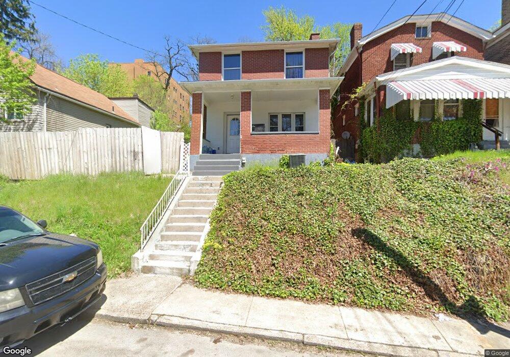
2515 Edgar St Pittsburgh, PA 15227
Carrick NeighborhoodEstimated Value: $136,000 - $151,229
3
Beds
2
Baths
1,144
Sq Ft
$126/Sq Ft
Est. Value
About This Home
This home is located at 2515 Edgar St, Pittsburgh, PA 15227 and is currently estimated at $144,307, approximately $126 per square foot. 2515 Edgar St is a home located in Allegheny County with nearby schools including Pittsburgh Concord K-5, Pittsburgh South Brook, and Pittsburgh Carrick High School.
Ownership History
Date
Name
Owned For
Owner Type
Purchase Details
Closed on
Apr 23, 2014
Sold by
Gilg Stephen R
Bought by
Williams Vincent D
Current Estimated Value
Home Financials for this Owner
Home Financials are based on the most recent Mortgage that was taken out on this home.
Original Mortgage
$64,705
Outstanding Balance
$49,483
Interest Rate
4.5%
Mortgage Type
FHA
Estimated Equity
$94,824
Purchase Details
Closed on
Sep 11, 1995
Sold by
Luft Ii Edward J and Luft Debra A
Bought by
Luft Debra A
Create a Home Valuation Report for This Property
The Home Valuation Report is an in-depth analysis detailing your home's value as well as a comparison with similar homes in the area
Home Values in the Area
Average Home Value in this Area
Purchase History
| Date | Buyer | Sale Price | Title Company |
|---|---|---|---|
| Williams Vincent D | $65,900 | -- | |
| Luft Debra A | -- | -- |
Source: Public Records
Mortgage History
| Date | Status | Borrower | Loan Amount |
|---|---|---|---|
| Open | Williams Vincent D | $64,705 |
Source: Public Records
Tax History Compared to Growth
Tax History
| Year | Tax Paid | Tax Assessment Tax Assessment Total Assessment is a certain percentage of the fair market value that is determined by local assessors to be the total taxable value of land and additions on the property. | Land | Improvement |
|---|---|---|---|---|
| 2025 | $938 | $40,700 | $14,200 | $26,500 |
| 2024 | $938 | $40,700 | $14,200 | $26,500 |
| 2023 | $938 | $40,700 | $14,200 | $26,500 |
| 2022 | $926 | $40,700 | $14,200 | $26,500 |
| 2021 | $839 | $40,700 | $14,200 | $26,500 |
| 2020 | $921 | $40,700 | $14,200 | $26,500 |
| 2019 | $921 | $40,700 | $14,200 | $26,500 |
| 2018 | $646 | $40,700 | $14,200 | $26,500 |
| 2017 | $921 | $40,700 | $14,200 | $26,500 |
| 2016 | $193 | $40,700 | $14,200 | $26,500 |
| 2015 | $193 | $58,700 | $14,200 | $44,500 |
| 2014 | $1,299 | $58,700 | $14,200 | $44,500 |
Source: Public Records
Map
Nearby Homes
- 2445 Brownsville Rd
- 0 Brownsville Rd Unit 1689715
- 11 Maytide St
- 26 Carrick Ave
- 37-39 Merritt Ave
- 134 Kirk Ave
- 2722 Bethesda St
- 2382 Edgar St
- 31 Claus Ave
- 29 Claus Ave
- 30 Stewart Ave
- 131 Stewart Ave
- 43 Stewart Ave
- 21 Stewart Ave
- 2812 Brentwood Ave
- 2819 Brentwood Ave
- 2832 Clermont Ave
- 2923-2925 Brownsville Rd
- 108 Bellanca Ave
- 208 Newburn Ave