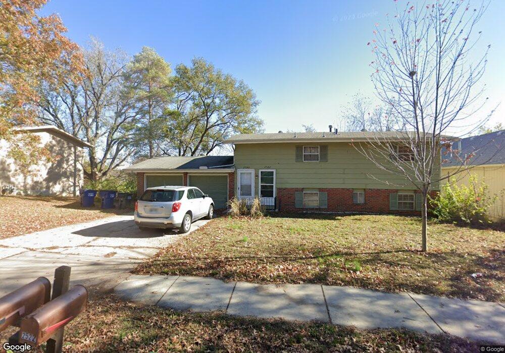
2520 Ousdahl Rd Lawrence, KS 66046
Estimated Value: $219,000 - $256,000
4
Beds
2
Baths
1,688
Sq Ft
$143/Sq Ft
Est. Value
About This Home
This home is located at 2520 Ousdahl Rd, Lawrence, KS 66046 and is currently estimated at $241,467, approximately $143 per square foot. 2520 Ousdahl Rd is a home located in Douglas County with nearby schools including Schwegler Elementary School, Billy Mills Middle School, and Lawrence High School.
Ownership History
Date
Name
Owned For
Owner Type
Purchase Details
Closed on
Jun 3, 2004
Sold by
Bjt & Associates Llc
Bought by
Norris Timothy M
Current Estimated Value
Home Financials for this Owner
Home Financials are based on the most recent Mortgage that was taken out on this home.
Original Mortgage
$88,400
Outstanding Balance
$44,138
Interest Rate
6.32%
Mortgage Type
Purchase Money Mortgage
Estimated Equity
$197,329
Create a Home Valuation Report for This Property
The Home Valuation Report is an in-depth analysis detailing your home's value as well as a comparison with similar homes in the area
Home Values in the Area
Average Home Value in this Area
Purchase History
| Date | Buyer | Sale Price | Title Company |
|---|---|---|---|
| Norris Timothy M | -- | Commerce Title |
Source: Public Records
Mortgage History
| Date | Status | Borrower | Loan Amount |
|---|---|---|---|
| Open | Norris Timothy M | $88,400 |
Source: Public Records
Tax History Compared to Growth
Tax History
| Year | Tax Paid | Tax Assessment Tax Assessment Total Assessment is a certain percentage of the fair market value that is determined by local assessors to be the total taxable value of land and additions on the property. | Land | Improvement |
|---|---|---|---|---|
| 2025 | $3,163 | $26,013 | $5,750 | $20,263 |
| 2024 | $3,001 | $24,737 | $5,405 | $19,332 |
| 2023 | $2,992 | $23,552 | $5,175 | $18,377 |
| 2022 | $2,698 | $21,134 | $4,830 | $16,304 |
| 2021 | $2,393 | $18,063 | $3,795 | $14,268 |
| 2020 | $2,222 | $16,881 | $3,795 | $13,086 |
| 2019 | $2,112 | $16,077 | $3,449 | $12,628 |
| 2018 | $1,941 | $14,697 | $3,449 | $11,248 |
| 2017 | $1,906 | $14,272 | $3,449 | $10,823 |
| 2016 | $1,847 | $14,456 | $2,760 | $11,696 |
| 2015 | -- | $14,571 | $2,760 | $11,811 |
| 2014 | -- | $14,674 | $2,760 | $11,914 |
Source: Public Records
Map
Nearby Homes
- 2837 Maine Ct
- 1305 W 21st St
- 2728 Chipperfield Rd
- 1620 W 20th Terrace
- 1633 W 20th St
- 1704 W 20th St
- 912 W 30th Terrace
- 314 Oklahoma St
- 2709 Lawrence Ave
- 1801 Missouri St
- 3013 W 23rd Terrace
- 1807 Alabama St
- 3018 Topeka Ln
- 2301 Massachusetts St
- 2116 Kentucky St
- 2046 Kentucky St
- 1729 Mississippi St
- 2045 Massachusetts St
- 2028 New Hampshire St
- 2407 Yosemite Dr
- 2526 Ousdahl Rd
- 2524 Ousdahl Rd
- 2514 Ousdahl Rd
- 2521 Ousdahl Rd
- 2508 Ousdahl Rd
- 2532 Ousdahl Rd
- 2527 Ousdahl Rd
- 2515 Ousdahl Rd
- 2533 Ousdahl Rd
- 2502 Ousdahl Rd
- 1603 W 25th St
- 2539 Ousdahl Rd
- 2538 Ousdahl Rd
- 1611 W 25th St
- 1510 W 25 Ct #4
- 2520 Cedarwood Ave
- 2526 Cedarwood Ave
- 1510 W 25th Ct Unit F1
- 1510 W 25th Ct
- 1510 W 25th Ct Unit F3