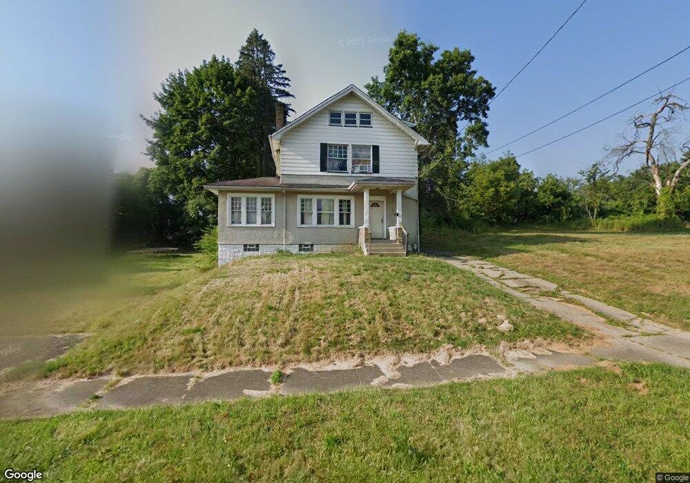
253 E Dewey Ave Youngstown, OH 44507
Erie NeighborhoodEstimated Value: $54,000 - $69,000
3
Beds
2
Baths
1,664
Sq Ft
$37/Sq Ft
Est. Value
About This Home
This home is located at 253 E Dewey Ave, Youngstown, OH 44507 and is currently estimated at $61,911, approximately $37 per square foot. 253 E Dewey Ave is a home located in Mahoning County with nearby schools including Taft Elementary School, Williamson Elementary School, and East High School.
Ownership History
Date
Name
Owned For
Owner Type
Purchase Details
Closed on
Jun 24, 2021
Bought by
Da4 Properties Llc
Current Estimated Value
Purchase Details
Closed on
Dec 5, 2019
Bought by
Sxo Investments Llc
Purchase Details
Closed on
May 2, 1996
Sold by
Schneider Michael
Bought by
Michell Robert T
Home Financials for this Owner
Home Financials are based on the most recent Mortgage that was taken out on this home.
Original Mortgage
$40,286
Interest Rate
7.86%
Mortgage Type
FHA
Purchase Details
Closed on
Nov 27, 1991
Bought by
Schneider Michael
Create a Home Valuation Report for This Property
The Home Valuation Report is an in-depth analysis detailing your home's value as well as a comparison with similar homes in the area
Home Values in the Area
Average Home Value in this Area
Purchase History
| Date | Buyer | Sale Price | Title Company |
|---|---|---|---|
| Da4 Properties Llc | -- | -- | |
| Sxo Investments Llc | -- | -- | |
| Michell Robert T | $39,900 | -- | |
| Schneider Michael | $11,000 | -- |
Source: Public Records
Mortgage History
| Date | Status | Borrower | Loan Amount |
|---|---|---|---|
| Previous Owner | Michell Robert T | $40,286 |
Source: Public Records
Tax History
| Year | Tax Paid | Tax Assessment Tax Assessment Total Assessment is a certain percentage of the fair market value that is determined by local assessors to be the total taxable value of land and additions on the property. | Land | Improvement |
|---|---|---|---|---|
| 2025 | $350 | $8,070 | $820 | $7,250 |
| 2024 | $396 | $8,070 | $820 | $7,250 |
| 2023 | $394 | $8,070 | $820 | $7,250 |
| 2022 | $194 | $3,030 | $820 | $2,210 |
| 2021 | $194 | $3,030 | $820 | $2,210 |
| 2020 | $204 | $3,030 | $820 | $2,210 |
| 2019 | $209 | $2,880 | $780 | $2,100 |
| 2018 | $243 | $2,880 | $780 | $2,100 |
| 2017 | $208 | $2,880 | $780 | $2,100 |
| 2016 | $228 | $3,410 | $780 | $2,630 |
| 2015 | $235 | $3,410 | $780 | $2,630 |
| 2014 | $222 | $3,410 | $780 | $2,630 |
| 2013 | $219 | $3,410 | $780 | $2,630 |
Source: Public Records
Map
Nearby Homes
- 95 E Earle Ave
- 52 E Earle Ave
- 609 E Dewey Ave
- 353 Cornell Ave
- 328 Marmion Ave
- 564 Miller St
- 727 Wilbur Ave
- 702 Dickson St
- 148 Saint Louis Ave
- 641 Benwood Ave
- 637 Lee Ave
- 848 Cameron Ave
- 863 Pasadena Ave
- 28 W Philadelphia Ave
- 3031 Market St
- 868 Cameron Ave
- 152 Regent St
- 852 Marmion Ave
- 320 E Auburndale Ave
- 32 E Avondale Ave
- 249 E Dewey Ave
- 257 E Dewey Ave
- 245 E Dewey Ave
- 261 E Dewey Ave
- 239 E Dewey Ave
- 256 E Laclede Ave
- 265 E Dewey Ave
- 260 E Laclede Ave
- 250 E Laclede Ave
- 266 E Laclede Ave
- 246 E Laclede Ave
- 269 E Dewey Ave
- 252 E Dewey Ave
- 237 E Dewey Ave
- 270 E Laclede Ave
- 244 E Dewey Ave
- 256 E Dewey Ave
- 258 E Dewey Ave
- 264 E Dewey Ave
- 236 E Laclede Ave
Your Personal Tour Guide
Ask me questions while you tour the home.