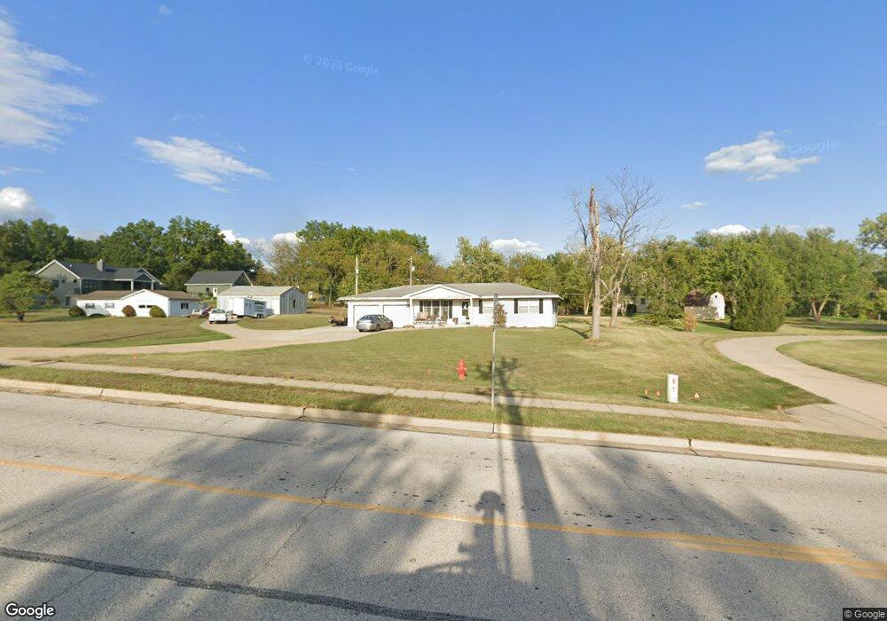
2530 Bates Rd O Fallon, MO 63368
Estimated Value: $266,000 - $295,000
3
Beds
2
Baths
1,120
Sq Ft
$246/Sq Ft
Est. Value
About This Home
This home is located at 2530 Bates Rd, O Fallon, MO 63368 and is currently estimated at $275,468, approximately $245 per square foot. 2530 Bates Rd is a home located in St. Charles County with nearby schools including Twin Chimneys Elementary School, Fort Zumwalt West Middle School, and Fort Zumwalt West High School.
Ownership History
Date
Name
Owned For
Owner Type
Purchase Details
Closed on
Aug 15, 2018
Sold by
Kirn Louis O
Bought by
Kirn Mark L
Current Estimated Value
Purchase Details
Closed on
Mar 29, 2010
Sold by
Montileone Karen S
Bought by
Kirn Mark L
Purchase Details
Closed on
May 2, 2005
Sold by
Schildroth Colleen A
Bought by
Kirn Mary Jean
Purchase Details
Closed on
Jun 8, 2000
Sold by
Dickherber William J and Dickherber Carol J
Bought by
Kirn Mark L and Schildroth Coleen A
Home Financials for this Owner
Home Financials are based on the most recent Mortgage that was taken out on this home.
Original Mortgage
$90,000
Interest Rate
8.13%
Create a Home Valuation Report for This Property
The Home Valuation Report is an in-depth analysis detailing your home's value as well as a comparison with similar homes in the area
Home Values in the Area
Average Home Value in this Area
Purchase History
| Date | Buyer | Sale Price | Title Company |
|---|---|---|---|
| Kirn Mark L | -- | None Available | |
| Kirn Mark L | -- | None Available | |
| Kirn Mary Jean | $81,814 | Assured Title Co | |
| Kirn Mark L | -- | -- |
Source: Public Records
Mortgage History
| Date | Status | Borrower | Loan Amount |
|---|---|---|---|
| Previous Owner | Kirn Mark L | $90,000 |
Source: Public Records
Tax History
| Year | Tax Paid | Tax Assessment Tax Assessment Total Assessment is a certain percentage of the fair market value that is determined by local assessors to be the total taxable value of land and additions on the property. | Land | Improvement |
|---|---|---|---|---|
| 2025 | $2,103 | $30,870 | -- | -- |
| 2023 | $2,101 | $33,521 | $0 | $0 |
| 2022 | $1,770 | $26,197 | $0 | $0 |
| 2021 | $1,769 | $26,197 | $0 | $0 |
| 2020 | $2,711 | $26,098 | $0 | $0 |
| 2019 | $2,705 | $26,098 | $0 | $0 |
| 2018 | $2,950 | $28,397 | $0 | $0 |
| 2017 | $2,940 | $28,397 | $0 | $0 |
| 2016 | $2,922 | $28,072 | $0 | $0 |
| 2015 | $2,749 | $28,072 | $0 | $0 |
| 2014 | $2,700 | $26,676 | $0 | $0 |
Source: Public Records
Map
Nearby Homes
- 312 Chestnut Creek Cir
- 756 Thunder Hill Dr
- 7719 Boardwalk Tower Cir
- 2613 Tysons Pkwy
- 653 Covered Bridge Ln
- New Build Glacier "E" at Dragonstone
- New Build Rainier "B" - Dragonstone
- New Build Rainier "F" - Dragonstone
- New Build Savannah "E" at Dragonstone
- 0 Unknown Unit MIS22064590
- 0 Unknown Unit MIS25074823
- 0 Unknown Unit MIS25074812
- 0 Unknown Unit MIS25074874
- 0 Unknown Unit MIS25074843
- 0 Unknown Unit MIS25074879
- 0 Unknown Unit MIS25074793
- 0 Unknown Unit MIS25074833
- 0 Unknown Unit MIS22064605
- 0 Unknown Unit MIS22064597
- 7409 Heathermoor Ln
- 2542 Bates Rd
- 1166 Saint Theresa Ln
- 2518 Bates Rd
- 304 Chestnut Creek Cir
- 1166 Saint Theresa Dr
- 302 Chestnut Creek Cir
- 306 Chestnut Creek Cir
- 317 Heritage Commons Cir
- 317 Heritage Commons Cir Unit 210
- 315 Heritage Commons Cir
- 315 Heritage Commons Cir
- 315 Heritage Commons Cir Unit 209
- 311 Heritage Commons Cir
- 311 Heritage Commons Cir
- 311 Heritage Commons Cir Unit 208
- 321 Heritage Commons Cir
- 300 Chestnut Creek Cir
- 307 Heritage Commons Cir
- 300 Chestnut Creek Cir
- 323 Heritage Commons Cir