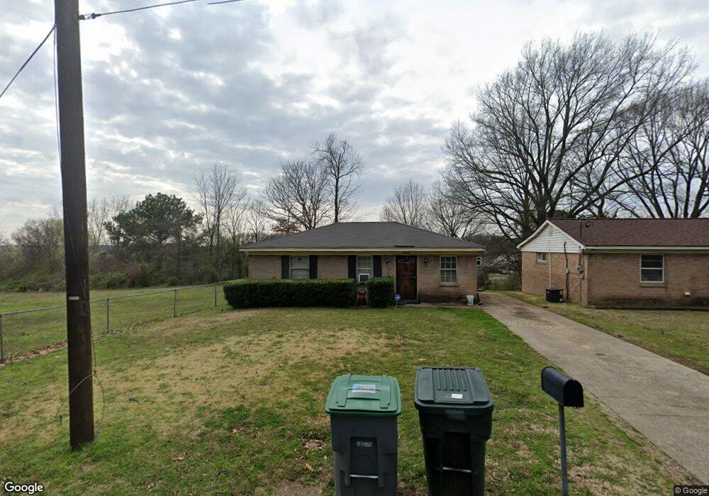
2555 Mcrae Rd Memphis, TN 38114
Southeast Memphis NeighborhoodEstimated Value: $59,669 - $121,000
2
Beds
1
Bath
936
Sq Ft
$95/Sq Ft
Est. Value
About This Home
This home is located at 2555 Mcrae Rd, Memphis, TN 38114 and is currently estimated at $88,917, approximately $94 per square foot. 2555 Mcrae Rd is a home located in Shelby County with nearby schools including Hamilton High School, Believe Memphis Academy Charter School, and Memphis College Preparatory.
Ownership History
Date
Name
Owned For
Owner Type
Purchase Details
Closed on
Feb 9, 2006
Sold by
Weatherspoon Leatha and Holmes Leatha
Bought by
Crawford William C
Current Estimated Value
Home Financials for this Owner
Home Financials are based on the most recent Mortgage that was taken out on this home.
Original Mortgage
$31,716
Outstanding Balance
$17,791
Interest Rate
6.14%
Mortgage Type
Purchase Money Mortgage
Estimated Equity
$71,126
Create a Home Valuation Report for This Property
The Home Valuation Report is an in-depth analysis detailing your home's value as well as a comparison with similar homes in the area
Home Values in the Area
Average Home Value in this Area
Purchase History
| Date | Buyer | Sale Price | Title Company |
|---|---|---|---|
| Crawford William C | -- | Tri State Title & Escrow Inc |
Source: Public Records
Mortgage History
| Date | Status | Borrower | Loan Amount |
|---|---|---|---|
| Open | Crawford William C | $31,716 |
Source: Public Records
Tax History Compared to Growth
Tax History
| Year | Tax Paid | Tax Assessment Tax Assessment Total Assessment is a certain percentage of the fair market value that is determined by local assessors to be the total taxable value of land and additions on the property. | Land | Improvement |
|---|---|---|---|---|
| 2025 | $299 | $12,475 | $2,750 | $9,725 |
| 2024 | $299 | $8,825 | $800 | $8,025 |
| 2023 | $538 | $8,825 | $800 | $8,025 |
| 2022 | $538 | $8,825 | $800 | $8,025 |
| 2021 | $544 | $8,825 | $800 | $8,025 |
| 2020 | $589 | $8,125 | $800 | $7,325 |
| 2019 | $589 | $8,125 | $800 | $7,325 |
| 2018 | $589 | $8,125 | $800 | $7,325 |
| 2017 | $334 | $8,125 | $800 | $7,325 |
| 2016 | $365 | $8,350 | $0 | $0 |
| 2014 | $365 | $8,350 | $0 | $0 |
Source: Public Records
Map
Nearby Homes
- 2428 Rozelle St
- 2416 Verdun St
- 2386 Bridgeport Dr
- 2944 Millbranch Rd
- 1490 Lockhaven Ave
- 1473 Carlton Rd
- 1495 Compton Ave
- 2601 Darlene St
- 0 Carlton Rd
- 2377 Warren St
- 2196 Ketchum Rd
- 1408 Eloise Rd
- 1385 Eloise Rd
- 1560 Cane Rd
- 2180 Elvis Presley Blvd
- 2410 W Hollyford Rd
- 2067 Corry Rd
- 1078 N Ball Rd
- 3065 Childress Rd
- 3061 Childress Rd
- 2551 Mcrae Rd
- 2578 Bridgeport Dr
- 2594 Bridgeport Dr
- 2574 Bridgeport Dr
- 2545 Judson St
- 2541 Judson St
- 2526 Manchester Rd
- 2530 Manchester Rd
- 1711 Clementine Rd
- 2560 Bridgeport Dr
- 2550 Bridgeport Dr
- 2533 Judson St
- 2522 Manchester Rd
- 1761 Wendy Dr
- 2534 Manchester Rd
- 2527 Judson St
- 2579 Bridgeport Dr
- 1707 Clementine Rd
- 2519 Mcrae Rd
- 1765 Wendy Dr