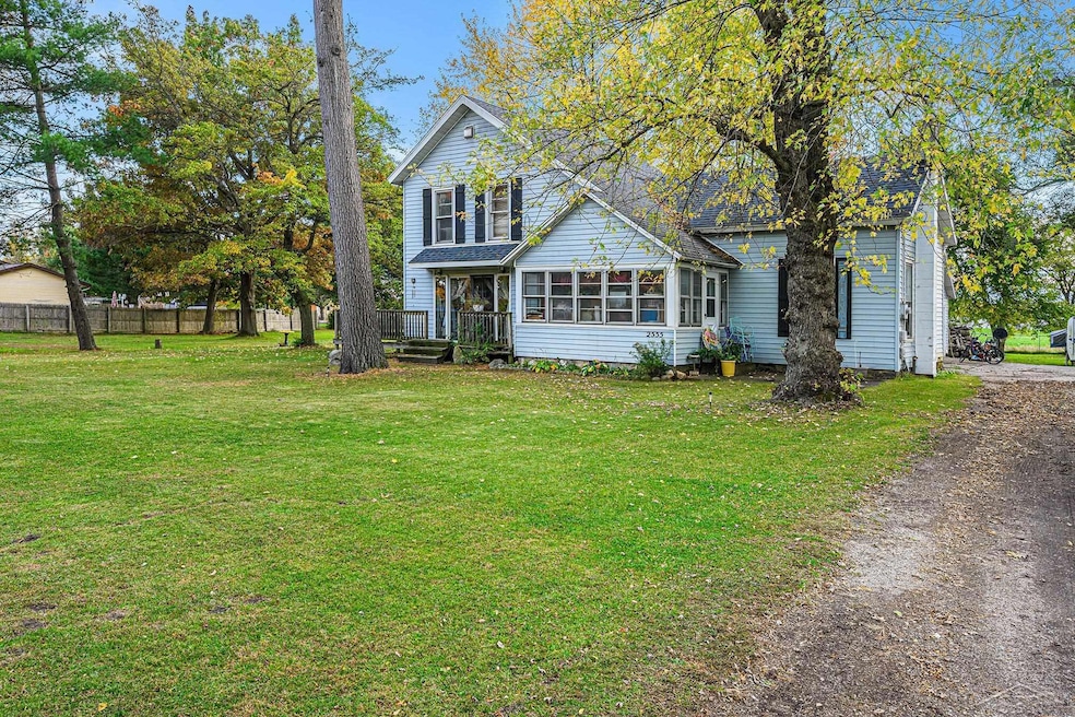
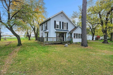
2555 W State Rd Hastings, MI 49058
Estimated payment $1,290/month
Highlights
- Victorian Architecture
- 1 Car Attached Garage
- Forced Air Heating System
About This Home
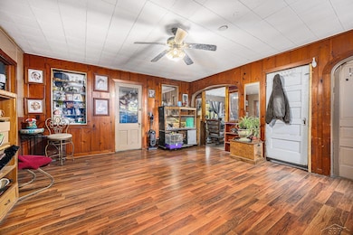
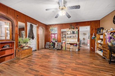
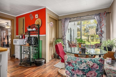
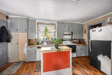
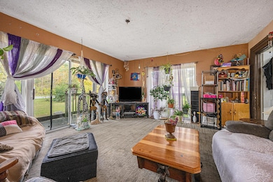
Step inside to find 10-foot ceilings and warm touches throughout, including new laminate flooring in the kitchen, dining room, and bathroom. The kitchen is in great condition, offering plenty of counter space and cabinetry, while the bathroom is clean and functional with room for future updates to make it your own. This home features vinyl siding, a 1-car attached garage, new shutters, and a new roof installed just 5 years ago. The Michigan basement has a cement floor with no moisture issues, perfect for storage or a workshop area. Though the windows are older, they remain in good condition — replacing them down the road could add extra efficiency and value. Outside, you’ll love the large yard shaded by mature trees, perfect for outdoor gatherings, gardening, or simply relaxing in the country air.
Listing Agent
JPAR - Great Lakes Bay Region License #SBR-6501448755 Listed on: 10/28/2025

Home Details
Home Type
- Single Family
Est. Annual Taxes
Year Built
- Built in 1900
Lot Details
- 1.16 Acre Lot
- 136 Ft Wide Lot
Parking
- 1 Car Attached Garage
Home Design
- Victorian Architecture
- Vinyl Siding
Interior Spaces
- 1,972 Sq Ft Home
- 1.5-Story Property
- Basement
Bedrooms and Bathrooms
- 4 Bedrooms
- 1 Full Bathroom
Utilities
- Forced Air Heating System
- Septic Tank
Listing and Financial Details
- Assessor Parcel Number 08-13-170-004-00
Map
Home Values in the Area
Average Home Value in this Area
Tax History
| Year | Tax Paid | Tax Assessment Tax Assessment Total Assessment is a certain percentage of the fair market value that is determined by local assessors to be the total taxable value of land and additions on the property. | Land | Improvement |
|---|---|---|---|---|
| 2025 | $782 | $105,600 | $0 | $0 |
| 2024 | $1,683 | $100,600 | $0 | $0 |
| 2023 | $2,516 | $76,000 | $0 | $0 |
| 2022 | $2,516 | $76,000 | $0 | $0 |
| 2021 | $2,516 | $70,100 | $0 | $0 |
| 2020 | $1,221 | $69,500 | $0 | $0 |
| 2019 | $1,221 | $69,100 | $0 | $0 |
| 2018 | $0 | $57,900 | $0 | $0 |
| 2017 | $0 | $56,200 | $0 | $0 |
| 2016 | -- | $52,200 | $0 | $0 |
| 2015 | -- | $48,100 | $0 | $0 |
| 2014 | -- | $48,100 | $0 | $0 |
Property History
| Date | Event | Price | List to Sale | Price per Sq Ft |
|---|---|---|---|---|
| 10/28/2025 10/28/25 | For Sale | $205,000 | -- | $104 / Sq Ft |
Purchase History
| Date | Type | Sale Price | Title Company |
|---|---|---|---|
| Warranty Deed | $59,500 | First American Title Ins Co | |
| Quit Claim Deed | -- | None Available | |
| Sheriffs Deed | $89,250 | None Available | |
| Warranty Deed | $109,000 | Metropolitan Title Company |
Mortgage History
| Date | Status | Loan Amount | Loan Type |
|---|---|---|---|
| Open | $58,404 | FHA | |
| Previous Owner | $111,000 | Purchase Money Mortgage |
Source: Michigan Multiple Listing Service
MLS Number: 50192794
APN: 13-170-004-00
Disclaimer: Certain information contained herein is derived from information provided by parties other than Homes.com. All information provided is deemed reliable, but is not guaranteed to be accurate and should be independently verified.
![]() Source MLS: MiRealSource
Source MLS: MiRealSource
Provided through IDX via MiRealSource. Courtesy of MiRealSource Shareholder. Copyright MiRealSource.
The information published and disseminated by MiRealSource is communicated verbatim, without change by MiRealSource, as filed with MiRealSource by its members. The accuracy of all information, regardless of source, is not guaranteed or warranted. All information should be independently verified.
Copyright 2025 MiRealSource. All rights reserved. The information provided hereby constitutes proprietary information of MiRealSource, Inc. and its shareholders, affiliates and licensees and may not be reproduced or transmitted in any form or by any means, electronic or mechanical, including photocopy, recording, scanning or any information storage and retrieval system, without written permission from MiRealSource, Inc.
- 0 V L Norway Ave Unit 25030541
- 3467 Rork Rd
- 2776 Woodruff Rd
- 1175 Hammond Rd
- Lot 21 Dakota Trail
- Lot 8 Dakota Trail
- Lot 3 Dakota Trail
- Lot 6 Dakota Trail
- Lot 9 Dakota Trail
- Lot 19 Dakota Trail
- Lot 1 Dakota Trail
- Lot 20 Dakota Trail
- Lot 2 Dakota Trail
- 1142 Hammond Rd
- 5613 Michigan 179
- 2295 Kathryn Dr
- 3144 Sugar Creek Dr
- 615 W High St
- 2539 Daisy Ln
- 4484 W State Rd
- 326 W State St
- 1611 S Hanover St
- 317 W Main St Unit B
- 822 Midvilla Ln
- 5317 W Cloverdale Rd
- 7100 92nd St SE
- 301 S Maple St SE
- 215 S Maple St SE
- 245 Kinsey St SE
- 8522 Jasonville Ct SE Unit 8522
- 6287 Laneview Dr SE
- 7020 Whitneyville Ave SE
- 1175 Emerson St
- 607 Trinity Dr Unit 1
- 532 Forrest St
- 5012 Verdure Pkwy
- 6020 W Fieldstone Hills Dr SE
- 3500-3540 60th St
- 5657 Sugarberry Dr SE
- 5425 East Paris Ave SE