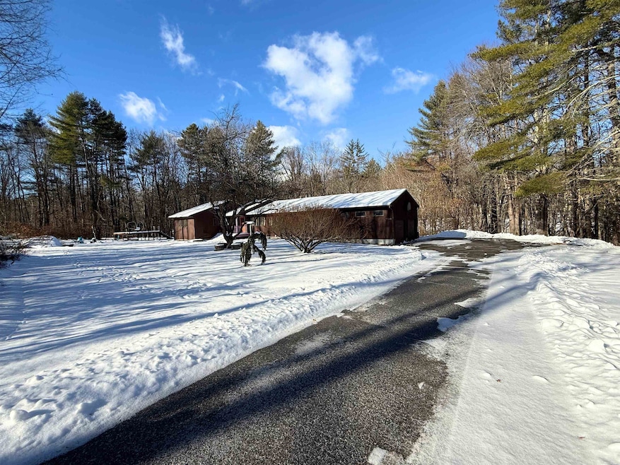
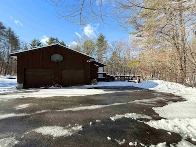
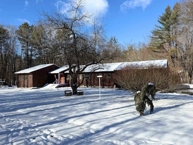
256 Middle Branch Rd New Boston, NH 03070
Estimated payment $3,400/month
Highlights
- River Front
- 3 Acre Lot
- Central Air
- New Boston Central School Rated A-
- Stream or River on Lot
- 2 Car Garage
About This Home
Four bedroom ranch set on a private lot with direct river frontage, offering a rare opportunity to create value in a peaceful waterfront setting. The single-level layout provides a solid footprint with strong potential for renovation and customization. Enjoy the privacy and natural surroundings while reimagining the home to suit your vision. *Short sale is subject to lender approval. Property being sold as-is. Utilities are shut off. Ideal for investors or buyers looking to make it their own and unlock the potential of a unique riverfront property. Interior photos coming soon - Delayed showings until 12/14.
Listing Agent
Keller Williams Realty Metro-Londonderry License #067277 Listed on: 12/12/2025

Home Details
Home Type
- Single Family
Est. Annual Taxes
- $9,304
Year Built
- Built in 1987
Lot Details
- 3 Acre Lot
- River Front
- Property fronts a private road
- Level Lot
- Property is zoned RA
Parking
- 2 Car Garage
Home Design
- Concrete Foundation
- Wood Frame Construction
- Shingle Roof
Interior Spaces
- Property has 1 Level
- Walk-Out Basement
Bedrooms and Bathrooms
- 4 Bedrooms
Outdoor Features
- Stream or River on Lot
Utilities
- Central Air
- Private Water Source
Listing and Financial Details
- Tax Block 19
- Assessor Parcel Number 2
Map
Home Values in the Area
Average Home Value in this Area
Tax History
| Year | Tax Paid | Tax Assessment Tax Assessment Total Assessment is a certain percentage of the fair market value that is determined by local assessors to be the total taxable value of land and additions on the property. | Land | Improvement |
|---|---|---|---|---|
| 2024 | $9,304 | $391,100 | $145,500 | $245,600 |
| 2023 | $7,959 | $391,100 | $145,500 | $245,600 |
| 2022 | $7,143 | $372,400 | $145,500 | $226,900 |
| 2021 | $6,889 | $372,400 | $145,500 | $226,900 |
| 2020 | $5,555 | $230,600 | $90,500 | $140,100 |
| 2019 | $7,834 | $230,600 | $90,500 | $140,100 |
| 2018 | $75 | $230,600 | $90,500 | $140,100 |
| 2017 | $5,615 | $230,600 | $90,500 | $140,100 |
| 2016 | $5,385 | $230,600 | $90,500 | $140,100 |
| 2015 | $5,681 | $212,700 | $84,600 | $128,100 |
| 2014 | $5,413 | $212,700 | $84,600 | $128,100 |
| 2013 | $5,156 | $212,700 | $84,600 | $128,100 |
Property History
| Date | Event | Price | List to Sale | Price per Sq Ft |
|---|---|---|---|---|
| 12/12/2025 12/12/25 | For Sale | $499,000 | -- | $182 / Sq Ft |
Purchase History
| Date | Type | Sale Price | Title Company |
|---|---|---|---|
| Deed | $230,000 | -- | |
| Foreclosure Deed | $263,000 | -- | |
| Warranty Deed | $170,000 | -- |
Mortgage History
| Date | Status | Loan Amount | Loan Type |
|---|---|---|---|
| Open | $238,100 | Purchase Money Mortgage | |
| Previous Owner | $134,000 | Purchase Money Mortgage |
Source: PrimeMLS
MLS Number: 5071889
APN: NBOS-000002-000019
Disclaimer: Certain information contained herein is derived from information provided by parties other than Homes.com. All information provided is deemed reliable, but is not guaranteed to be accurate and should be independently verified.
![]() Copyright 2025 PrimeMLS, Inc. All rights reserved. This information is deemed reliable, but not guaranteed. The data relating to real estate displayed on this display comes in part from the IDX Program of PrimeMLS. The information being provided is for consumers’ personal, non-commercial use and may not be used for any purpose other than to identify prospective properties consumers may be interested in purchasing.
Copyright 2025 PrimeMLS, Inc. All rights reserved. This information is deemed reliable, but not guaranteed. The data relating to real estate displayed on this display comes in part from the IDX Program of PrimeMLS. The information being provided is for consumers’ personal, non-commercial use and may not be used for any purpose other than to identify prospective properties consumers may be interested in purchasing.
- 450 Weare Rd
- 342 Weare Rd
- 179 Oak Hill Rd
- 95 Wright Dr
- 34 Lull Rd
- 77 Gould Rd
- 54 Briar Hill Rd
- Lot 1-50-1 Colburn Rd
- 252 Clark Hill Rd
- 93 Daniels Rd
- 103 Renshaw Rd
- 1 Old Coach Rd
- 16 Meetinghouse Hill Rd
- 624 S Stark Hwy
- 1 Cemetery Rd
- 196 Deering Center Rd
- 174 S Stark Hwy Unit 13
- 174 S Stark Hwy Unit 1
- 174 S Stark Hwy Unit 23
- 200 Mountain Rd
- 115 High Rock Rd Unit A
- 81 Orchard Path Rd
- 44 N Mast St Unit B
- 15 Mountain Rd Unit 201
- 15 Mountain Rd Unit 105
- 15 Mountain Rd Unit 106
- 15 Mountain Rd Unit 203
- 15 Mountain Rd Unit 205
- 15 Mountain Rd Unit 101
- 15 Mountain Rd Unit 202
- 15 Factory St
- 57 S Mast St Unit 2
- 86 Reservoir Dr
- 45 Greer Rd Unit 1
- 49 Greer Rd Unit 49 A Greer Road
- 29 Center St Unit 7
- 29 Center St Unit 5
- 5 Timberwood Dr Unit 106
- 5 Timberwood Dr Unit 207
- 174 Saint Anselms Dr