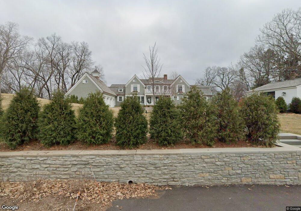
2560 Cedar Ridge Rd Wayzata, MN 55391
Estimated Value: $1,313,000 - $10,621,670
9
Beds
6
Baths
5,889
Sq Ft
$1,088/Sq Ft
Est. Value
About This Home
This home is located at 2560 Cedar Ridge Rd, Wayzata, MN 55391 and is currently estimated at $6,405,557, approximately $1,087 per square foot. 2560 Cedar Ridge Rd is a home located in Hennepin County with nearby schools including Groveland Elementary School, Minnetonka East Middle School, and Minnetonka Senior High School.
Ownership History
Date
Name
Owned For
Owner Type
Purchase Details
Closed on
Jul 22, 2025
Sold by
Keith W Tomlinson W and Keith Tracy C
Bought by
256 Llc
Current Estimated Value
Home Financials for this Owner
Home Financials are based on the most recent Mortgage that was taken out on this home.
Original Mortgage
$7,200,000
Outstanding Balance
$7,176,822
Interest Rate
5.63%
Mortgage Type
New Conventional
Estimated Equity
-$771,265
Purchase Details
Closed on
Mar 9, 2021
Sold by
Chute Edmund P and Nowlan Anne C
Bought by
Tomlinson Keith W and Tomlinson Tracy C
Home Financials for this Owner
Home Financials are based on the most recent Mortgage that was taken out on this home.
Original Mortgage
$2,100,000
Interest Rate
2%
Mortgage Type
New Conventional
Create a Home Valuation Report for This Property
The Home Valuation Report is an in-depth analysis detailing your home's value as well as a comparison with similar homes in the area
Purchase History
| Date | Buyer | Sale Price | Title Company |
|---|---|---|---|
| 256 Llc | $12,000,000 | Burnet Title | |
| Tomlinson Keith W | $4,175,000 | None Available |
Source: Public Records
Mortgage History
| Date | Status | Borrower | Loan Amount |
|---|---|---|---|
| Open | 256 Llc | $7,200,000 | |
| Previous Owner | Tomlinson Keith W | $2,100,000 |
Source: Public Records
Tax History
| Year | Tax Paid | Tax Assessment Tax Assessment Total Assessment is a certain percentage of the fair market value that is determined by local assessors to be the total taxable value of land and additions on the property. | Land | Improvement |
|---|---|---|---|---|
| 2024 | $84,345 | $6,976,400 | $3,974,400 | $3,002,000 |
| 2023 | $52,194 | $4,573,100 | $3,613,100 | $960,000 |
| 2022 | $40,416 | $3,890,000 | $3,441,000 | $449,000 |
| 2021 | $39,240 | $3,188,000 | $2,825,000 | $363,000 |
| 2020 | $37,555 | $3,082,000 | $2,735,000 | $347,000 |
| 2019 | $38,112 | $2,816,000 | $2,480,000 | $336,000 |
| 2018 | $38,765 | $2,834,000 | $2,480,000 | $354,000 |
| 2017 | $39,394 | $2,891,000 | $2,480,000 | $411,000 |
| 2016 | $41,244 | $2,967,000 | $2,430,000 | $537,000 |
| 2015 | $38,181 | $2,725,000 | $2,228,000 | $497,000 |
| 2014 | -- | $2,586,000 | $2,128,000 | $458,000 |
Source: Public Records
Map
Nearby Homes
- 2505 Cedar Point Dr
- 2770 Gale Rd
- 2670 Woolsey Ln
- 17870 Breezy Point Rd
- 17945 Breezy Point Rd
- 2918 County Road 101 S
- 18445 Northome Blvd
- 3449 Hamilton Ave
- 3114 County Road 101 S
- 325 Highcroft Ln
- 222 Ferndale Rd S Unit 103
- 222 Ferndale Rd S Unit 203
- 222 Ferndale Rd S Unit 105
- 935 Lake St E Unit 309
- 445 Bovey Rd
- 724 Widsten Cir
- 103 Edgewood Ct
- 875 Lake St N Unit 216
- 875 Lake St N Unit 318
- TBD1 Bushaway Rd
- 2550 Cedar Ridge Rd
- 2570 Cedar Ridge Rd
- 2565 2565 Cedar Ridge-Road-
- 2565 2565 Cedar Ridge Rd
- 2565 Cedar Ridge Rd
- 2580 Cedar Ridge Rd
- 2520 Cedar Ridge Rd
- 2550 Spirit Knob Rd
- 2530 Spirit Knob Rd
- 2550 2550 Spirit Knob-Road-
- 2600 Spirit Knob Rd
- 2600 Maplewood Cir E
- 2500 Spirit Knob Rd
- 2520 Cedar Point Dr
- 2540 Cedar Point Dr
- 2540 Cedar Point-Drive-
- 28XX Gale Rd
- 253X Spirit Knob Rd
- 2650 Maplewood Cir W
- 2650 2650 Maplewood-Circle-w
Your Personal Tour Guide
Ask me questions while you tour the home.