Estimated Value: $209,000 - $227,308
2
Beds
1
Bath
1,244
Sq Ft
$179/Sq Ft
Est. Value
About This Home
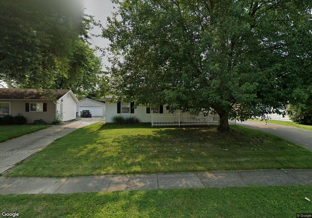
This home is located at 257 Fieldpoint Rd, Heath, OH 43056 and is currently estimated at $222,327, approximately $178 per square foot. 257 Fieldpoint Rd is a home located in Licking County with nearby schools including Garfield Elementary School, Stevenson Elementary School, and Heath Middle School.
Ownership History
Date
Name
Owned For
Owner Type
Purchase Details
Closed on
Aug 31, 1998
Sold by
Ardrey Roland C
Bought by
Mckee Mark D
Current Estimated Value
Home Financials for this Owner
Home Financials are based on the most recent Mortgage that was taken out on this home.
Original Mortgage
$67,900
Outstanding Balance
$14,668
Interest Rate
7.03%
Mortgage Type
New Conventional
Estimated Equity
$207,659
Create a Home Valuation Report for This Property
The Home Valuation Report is an in-depth analysis detailing your home's value as well as a comparison with similar homes in the area
Home Values in the Area
Average Home Value in this Area
Purchase History
| Date | Buyer | Sale Price | Title Company |
|---|---|---|---|
| Mckee Mark D | $77,900 | -- |
Source: Public Records
Mortgage History
| Date | Status | Borrower | Loan Amount |
|---|---|---|---|
| Open | Mckee Mark D | $67,900 |
Source: Public Records
Tax History Compared to Growth
Tax History
| Year | Tax Paid | Tax Assessment Tax Assessment Total Assessment is a certain percentage of the fair market value that is determined by local assessors to be the total taxable value of land and additions on the property. | Land | Improvement |
|---|---|---|---|---|
| 2024 | $2,487 | $57,790 | $18,660 | $39,130 |
| 2023 | $2,752 | $57,790 | $18,660 | $39,130 |
| 2022 | $2,175 | $40,110 | $9,100 | $31,010 |
| 2021 | $2,219 | $40,110 | $9,100 | $31,010 |
| 2020 | $2,234 | $40,110 | $9,100 | $31,010 |
| 2019 | $1,879 | $34,340 | $11,380 | $22,960 |
| 2018 | $1,899 | $0 | $0 | $0 |
| 2017 | $1,784 | $0 | $0 | $0 |
| 2016 | $1,642 | $0 | $0 | $0 |
| 2015 | $1,670 | $0 | $0 | $0 |
| 2014 | $2,347 | $0 | $0 | $0 |
| 2013 | $1,622 | $0 | $0 | $0 |
Source: Public Records
Map
Nearby Homes
- 255 Fieldpoint Rd
- 259 Fieldpoint Rd
- 253 Fieldpoint Rd
- 339 Parkview Dr
- 256 Fieldpoint Rd
- 260 Fieldpoint Rd
- 251 Fieldpoint Rd
- 272 Walden Rd
- 285 Parkview Dr
- 249 Fieldpoint Rd
- 250 Fieldpoint Rd
- 268 Walden Rd
- 281 Parkview Dr
- 247 Fieldpoint Rd
- 267 Walden Rd
- 262 Walden Rd
- 261 Walden Rd
- 277 Parkview Dr
- 245 Fieldpoint Rd
- 248 Fieldpoint Rd