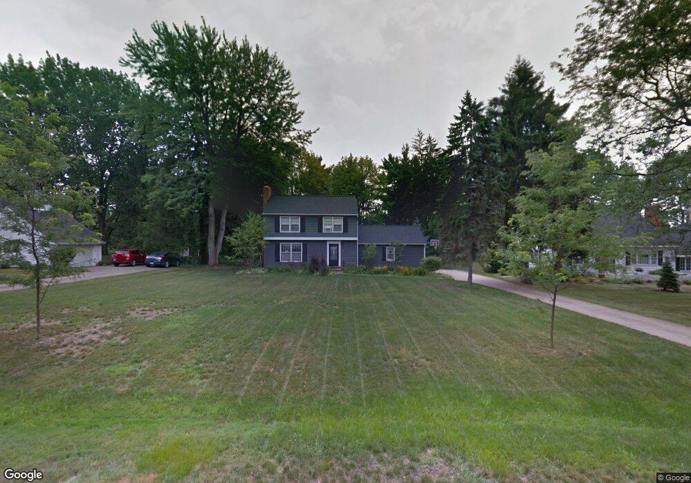
26 Colony Dr Hudson, OH 44236
Estimated Value: $311,000 - $412,000
3
Beds
3
Baths
1,484
Sq Ft
$250/Sq Ft
Est. Value
About This Home
This home is located at 26 Colony Dr, Hudson, OH 44236 and is currently estimated at $371,621, approximately $250 per square foot. 26 Colony Dr is a home located in Summit County with nearby schools including Ellsworth Hill Elementary School, East Woods Intermediate School, and Hudson Middle School.
Ownership History
Date
Name
Owned For
Owner Type
Purchase Details
Closed on
Aug 20, 2019
Sold by
Beseda Christopher T and Beseda Erin K
Bought by
Tullio Marcus and Tullio Jessica
Current Estimated Value
Purchase Details
Closed on
Feb 20, 2003
Sold by
Anne Kaplan Howard and Anne Mary
Bought by
Beseda Christopher T and Beseda Erin K
Home Financials for this Owner
Home Financials are based on the most recent Mortgage that was taken out on this home.
Original Mortgage
$132,000
Outstanding Balance
$56,986
Interest Rate
6.06%
Estimated Equity
$314,636
Purchase Details
Closed on
Aug 29, 1997
Sold by
Corona R Feuerhahn Trst
Bought by
Kaplan Howard and Kaplan Mary A
Home Financials for this Owner
Home Financials are based on the most recent Mortgage that was taken out on this home.
Original Mortgage
$130,500
Interest Rate
7.57%
Mortgage Type
New Conventional
Create a Home Valuation Report for This Property
The Home Valuation Report is an in-depth analysis detailing your home's value as well as a comparison with similar homes in the area
Home Values in the Area
Average Home Value in this Area
Purchase History
| Date | Buyer | Sale Price | Title Company |
|---|---|---|---|
| Tullio Marcus | $175,000 | None Available | |
| Beseda Christopher T | $165,000 | Guardian Title | |
| Kaplan Howard | $145,000 | -- |
Source: Public Records
Mortgage History
| Date | Status | Borrower | Loan Amount |
|---|---|---|---|
| Open | Beseda Christopher T | $132,000 | |
| Closed | Kaplan Howard | $130,500 | |
| Closed | Beseda Christopher T | $33,000 |
Source: Public Records
Tax History Compared to Growth
Tax History
| Year | Tax Paid | Tax Assessment Tax Assessment Total Assessment is a certain percentage of the fair market value that is determined by local assessors to be the total taxable value of land and additions on the property. | Land | Improvement |
|---|---|---|---|---|
| 2025 | $4,571 | $89,237 | $20,311 | $68,926 |
| 2024 | $4,571 | $89,237 | $20,311 | $68,926 |
| 2023 | $4,571 | $89,237 | $20,311 | $68,926 |
| 2022 | $4,021 | $69,948 | $15,747 | $54,201 |
| 2021 | $3,810 | $66,179 | $15,747 | $50,432 |
| 2020 | $4,006 | $66,180 | $15,750 | $50,430 |
| 2019 | $3,868 | $63,350 | $17,830 | $45,520 |
| 2018 | $3,854 | $63,350 | $17,830 | $45,520 |
| 2017 | $3,376 | $63,350 | $17,830 | $45,520 |
| 2016 | $3,464 | $54,860 | $17,830 | $37,030 |
| 2015 | $3,376 | $54,860 | $17,830 | $37,030 |
| 2014 | $3,386 | $54,860 | $17,830 | $37,030 |
| 2013 | $3,383 | $53,540 | $17,830 | $35,710 |
Source: Public Records
Map
Nearby Homes
- 21 Keswick Dr
- 148 Colony Dr
- 5974 Anna Lee Dr
- 94 Fox Trace Ln
- 5937 Ogilby Dr
- 5791 Sunset Dr
- 1705 Barlow Rd
- 116 W Case Dr
- 21 Atterbury Blvd
- 35 S Hayden Pkwy
- 77 Atterbury Blvd Unit 106
- 5532 Hudson Dr
- 311 W Streetsboro St
- 181 Boston Mills Rd
- 180 Atterbury Blvd
- 157 Hudson St
- 48 Prescott Dr
- 24 Morning Song Ln
- 6170 Nicholson Dr
- 734 Barlow Rd
- 34 Colony Dr
- 20 Colony Dr
- 1801 Stoney Hill Dr
- 40 Colony Dr
- 1785 Stoney Hill Dr
- 21 Colony Dr
- 1815 Stoney Hill Dr
- 35 Colony Dr
- 259 S Main St
- 267 S Main St
- 41 Colony Dr
- 48 Colony Dr
- 23 Clairhaven Dr
- 1779 Stoney Hill Dr
- 1775 Stoney Hill Dr Unit 1779
- 1829 Stoney Hill Dr
- 249 S Main St
- 34 Clairhaven Dr
- 36 Clairhaven Dr
- 1808 Stoney Hill Dr